INTRODUCTION
by David Hey
Central to writing an accurate historical article on a subject is to say what you mean and mean what you say, and of course to know what you're talking about, which is why I rarely intrude on a contributor's page unless something interesting crops up.
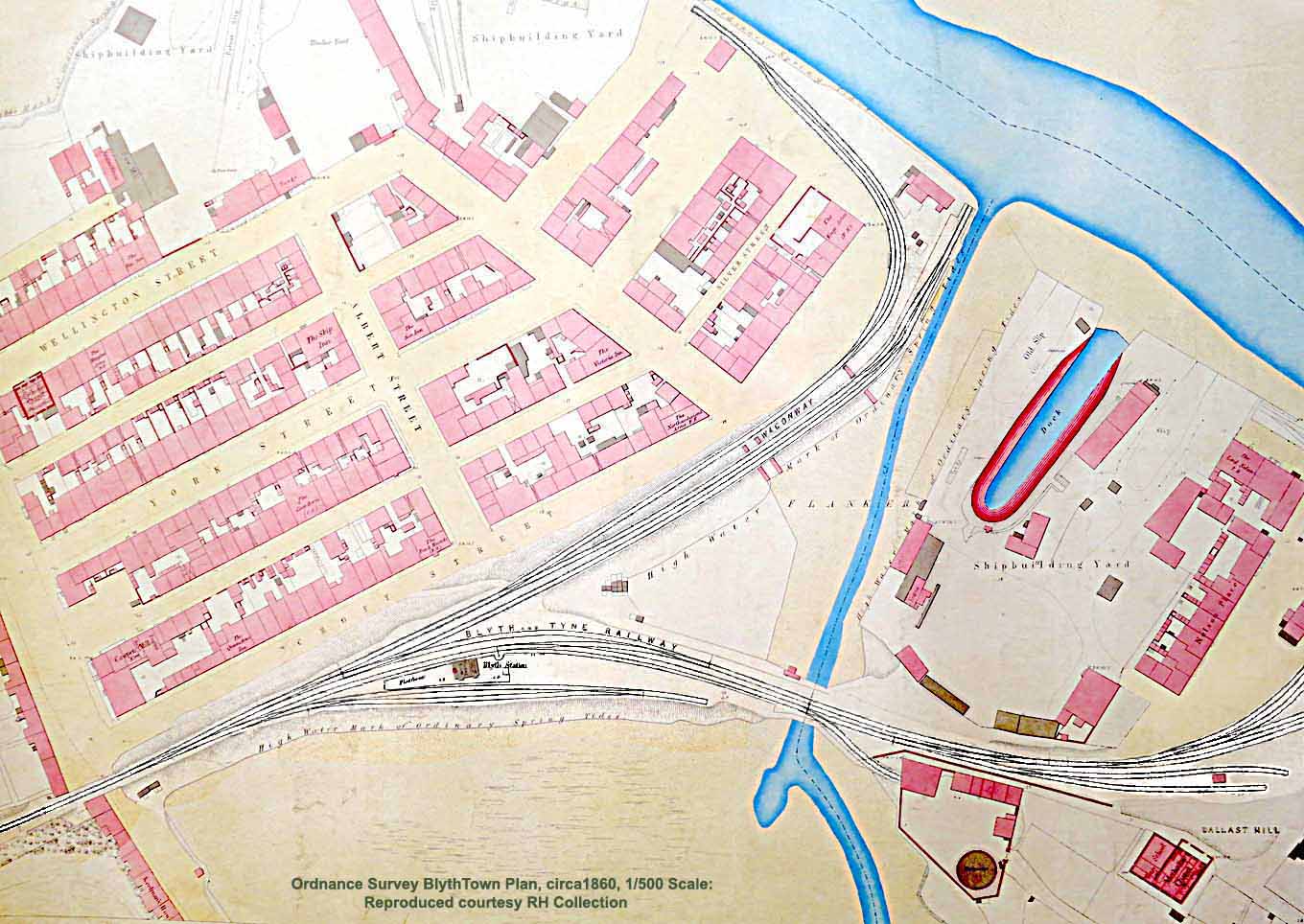
So I am hoping Phil will forgive me for muscling in with a very interesting email I've received from RH, who writes - 'I'm emailing you three photographs of a map I bought recently. I can't yet date it with absolute precision, but the first OS survey was possibly late 1850s or early 1860s - your visitors may be able to date it more precisely from their own knowledge of Blyth. An old postcard on Phil Hodgett's Flickr pages HERE includes a picture of Blyth gasworks c.1862, which might suggest an end-date for the survey.
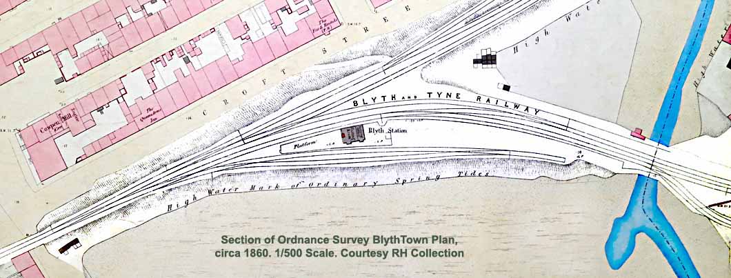
The map is a copy of the first edition 1/500 scale (10.56 feet to the mile) OS Town Plan showing the area of the first Blyth station lying immediately south of Croft Street. I thought the detailed information it holds might be of interest to your visitors, so before having the map framed I photographed it. The photos are not to professional or archive standard, but they do show the map clearly and without much distortion. I understand the 1st OS is long out of copyright, so please feel free to use the map images on the website if you so wish.
Finally, I hope the map might add a mite to the sum total of human knowledge by making reliable information available to other readers and researchers, as the only organised information I've found on the web that deals specifically with the first Blyth station is a photo of a North Eastern Railway locomotive at Croft Street on the Flickr site mentioned above, and a page on the 'Disused Stations' website HERE.'
Thanks RH, your input is greatly appreciated...
COWPEN & BLYTH 2
by Phil Hodgetts
It is amazing to see how David has superimposed the 1934 LNER map (below) over the Google image of 2006. A difficult task as the LNER map is not exactly to scale, yet with a bit of juggling in Photoshop David has managed to get a close fit. Fantastic to see the lines and station all in their respective positions in relation to the town as it is today. I never realised just how extensive the railway was in the heart of the town.
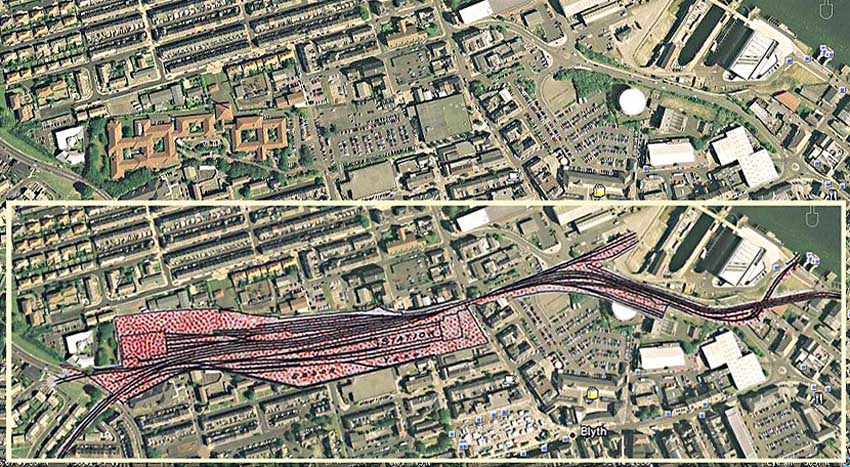
Starting from the lower left edge of the image we can see the level crossing over Cowpen Road. Just to the right of that is a large square building that was South Blyth engine shed. It was first built as a three road shed in 1879 and extended in 1895 to accommodate extra locomotives for the increased rail traffic to the town. The site is now occupied by the Blyth Community Hospital. The mass of sidings and the station itself covered a large area and is now occupied by Morrisons supermarket and car park. It is quite amazing to see that the modern buildings in the area are still outlined by the original shape of the station and shed site. Tree and wall lines are basically unchanged given that it is nearly 40 years since the demolition of the station and all its related structures.
Moving to the right over Turner Street we can follow the lines climbing out to the riverside staiths, and see the short stub to the tug spout. I remember the supermarket being built, Prestos it was then. In particular I recall the smell of newly laid Tarmac and the terracotta colour of the bricks used to build the car park walls; the supermarket facade looked palatial alongside the weather-stained architecture around it.
When shopping there, mum often gave me a cuff round the ear for persistently pestering her for a new toy car, usually a Matchbox toy. The French Street entrance to the car park reminds me of the time dad gave my older sister (only 12 at the time) driving lessons up and down the ramp to the car park. Just using the clutch to get the biting point, then climbing the ramp and letting the car roll back to the bottom before repeating the exercise again. It was a little Austin 7 minivan in Battleship Grey with registration NTY 403F, strange how the smallest details come to mind.
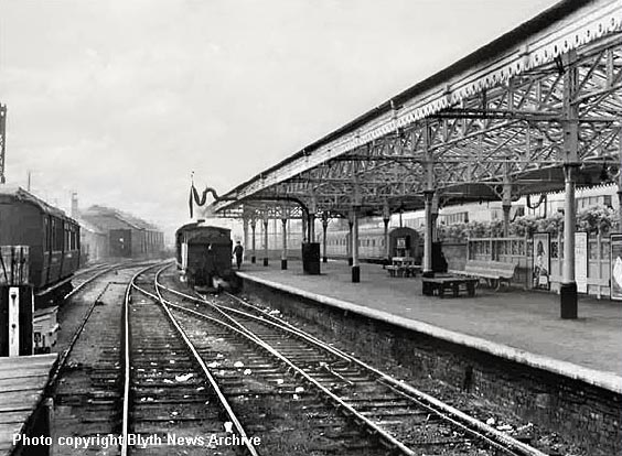
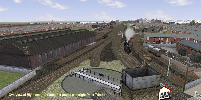
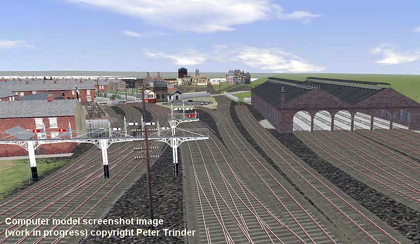
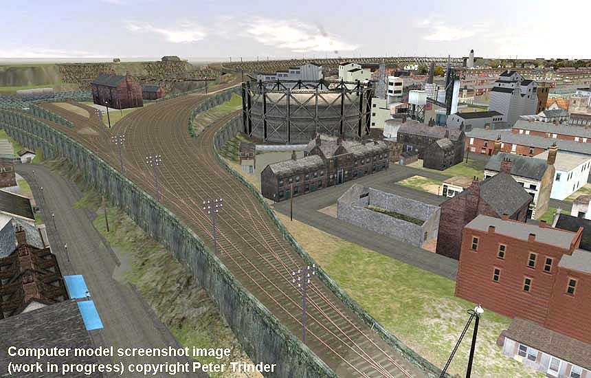
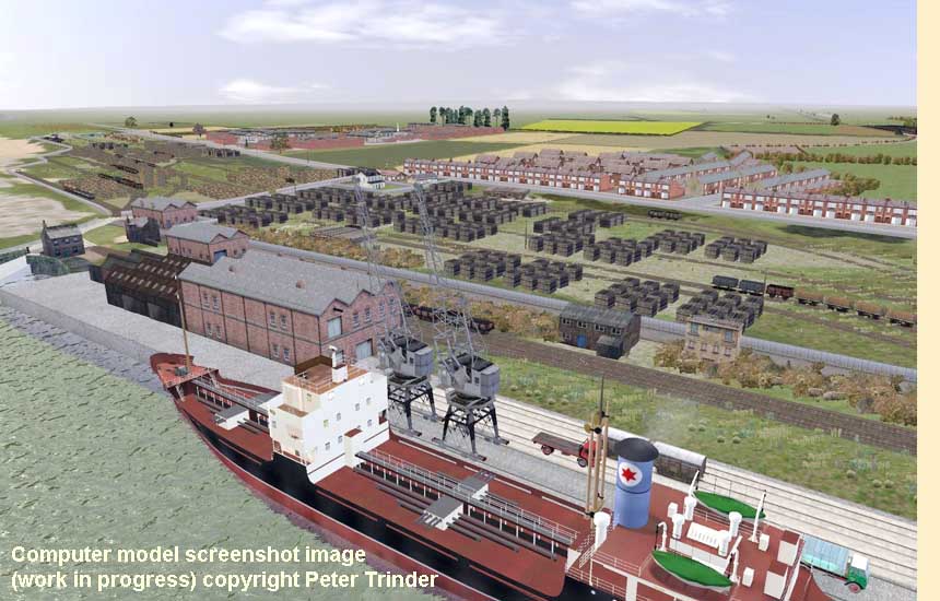
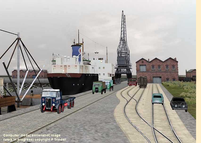
(Above) Peter Trinder is building a computer model of the Blyth & Tyne Railway circa 1950s-60s. Having already completed one version of the line south from Newsham to Percy Main and Whitehill Point, Peter has started a new improved version using new software. So far he has completed Newsham and South Blyth, and is currently working on the Old and New Staiths, New Blyth sidings and the Harbour. Peter is trying to make the trackwork as accurate as possible, but at the moment the buildings are just a near match until he has time to make accurate models from photos. This is an overview of the exit from Blyth station with Blyth South shed prominent in both shots. The computer model is very much work in progress - and like Ed Orwin's 'N' gauge scale layout on the following page, the research and design work required to achieve prototypical accuracy is quite remarkable. Peter adds - 'I have selected the most appropriate items for his model based on historical maps and such photos as I have available, including many I found on Phil Hodgett's page. Basically it's like going to the model shop, buying stuff off the shelf and putting it together to make a model railway...' The finished model will be quite superb!.
There is no doubt that the Internet is a great educational tool, but if you are serious about researching a particular subject it is important to pick the right sites. Often I feel it would have been better to have studied documented evidence at the Woodhorn Archives in Ashington or the Northumbria Archive rather than taking a giant leap into the relative obscurity of Internet-sourced faith. Sadly there are many inaccuracies on the web - and in books too, come to that!
Therefore I am grateful to retired railwayman, Ken Hedley, who has provided a concise history of the B&T Railway for this page. Ken started work on the railway as a 17 year-old cleaner at South Blyth shed in November 1945. In those days it was still LNER and Ken worked various jobs besides cleaning, until March 1947 when he left the railway to work in the coal mines as a Bevin Boy in lieu of National Service for two years. On returning to the railway, Ken had been promoted to fireman in his absence and became a passed fireman in 1958, which meant he was a qualified driver awaiting a driving vacancy. However, it wasn't until ten years later, after countless hours of driving to cover for holidays and sickness etc, that he was finally promoted to driver in 1968. In 1974, Ken did a year as acting Traction Inspector at Newcastle before being promoted to Train Crew Supervisor at the new diesel depot at Cambois where he remained until taking early retirement in 1990 at the age of 62 after 45 years service. Since 1992, Ken has been a volunteer driver on the North Tyne Steam Railway and is still enjoying it at the ripe old age of 81!
The Blyth and Tyne Branch Railway - 1
by Ken Hedley
The Blyth & Tyne branch once ran from Manors Junction, Newcastle, to Newbiggin by the sea, a distance of 25 miles. There were 16 stations, namely: Manors North, Jesmond, West Jesmond, South Gosforth, Long Benton, Benton Backworth, Seghill, Seaton Delaval, Hartley, Newsham, Bebside, Bedlington, North Seaton, Ashington and the terminus at Newbiggin. A branch line ran from Bedlington junction to Morpeth connecting with the East Coast Main Line, which included two stations at Choppington and Hepscott; this was a double line from Bedlngton to Choppington and single line from there to Morpeth. Another branch ran from Hartley to Monkseaton where it connected with the North Tyneside electric loop, though there were no stations on this line and it was single line throughout for approx 4 miles.
The original Blyth & Tyne railway ran from Blyth to Percy Main on the Tyne, but after it was absorbed by the North Eastern Railway in 1874, other extensions were built. A steam passenger service ran from Manors (approx a quarter mile from Newcastle Central) to Newbiggin, 25 miles distance running an express service between Manors and Backworth in both directions on the North Tyneside electric line, the intermediate stations being served by the electric trains and with a journey time of 1 hour and 5mins.
The trains were worked mainly by crews from South Blyth shed using ex North Eastern Class G5 0-4-4T locos while others were worked by Heaton shed's Gresley V1 locos. Another service ran between Blyth and Monkseaton on the North Tyne electric loop (popularly known as the Monkey) and were formerly worked by Sentinel steam coaches and later by push-pull trains with 2 coaches and a G5 loco. This branch was known as the Avenue Branch as it crossed an avenue of trees associated with Seaton Delaval Hall owned by Lord Hastings. In 1956 the stations of Seghill and Seaton Delaval were closed and the passenger service was altered to run between Newbiggin and Monkseaton via the Avenue branch, which then meant passengers had to change to trains on the North Tyne Loop to get to Newcastle. This was worked by South Blyth crews; a push-pull service with a G5 loco and 3 coaches on an hourly basis, with the journey time taking about 45mins both ways.
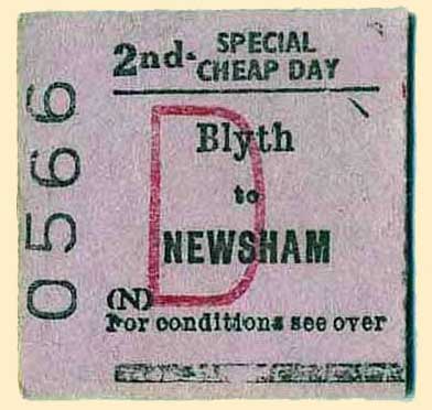 (Left) Choosing suitable photos to illustrate Ken's Hedley's contribution to this page has been something of a dilemma, untiI I saw this train ticket for sale on eBay. The standard Edmondson 2nd class cheap day return card ticket was used universally across the railway network once upon a time. This is the severed half of a return ticket between Newsham and Blyth, perhaps used by a commuter or shopper. We can tell that the ticket stub for the outward journey from Newsham to Blyth has been retained by railway staff at Blyth station, however the remaining part of the ticket for the return journey was not collected by railway staff at Newsham station, hence its survival to this day. It's a wonder it didn't end up on the fire or in the bin, as railway tickets had no real value for journeys made, unless of course it was retained for sentimental reasons or it was a commemorative ticket, or one used by a rail enthusiast for a route that was about to be closed.
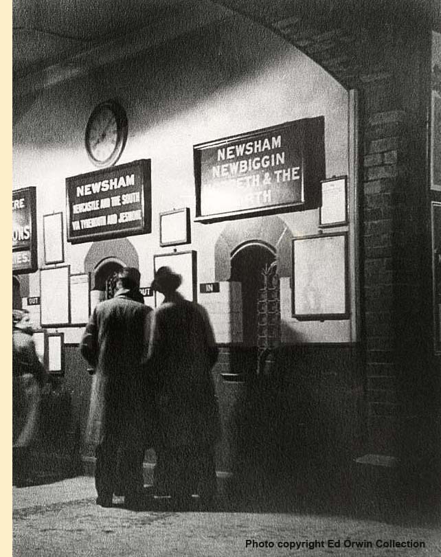 (Right) The ticket immediately made me think of Ed Orwin's fantastic collection of archive material of the B & T, which includes this interesting photo, showing the interior of the booking hall at Blyth station.
 Ed informs me that the ticket office is not of Newsham Station, which many people think, since Newsham would not be identifying itself as a destination as indicated by the boards above the ticket windows. Blyth station had three ticket windows in its foyer and the way the destinations are presented makes him 99% sure that the photo is of Blyth station ticket office.
The left window advertises Newsham, Newcastle and the south via Tynemouth and Jesmond, the window on the right Newsham, Newbiggin, Morpeth and the north, all of which would make sense at Blyth, but nowhere else on the Blyth & Tyne.
I would dare suggest that the photo is post WW2 late 40's possibly early 50's given the fashion - raincoats and trilby hats. The woman's hair is very 1940's too. I wonder which film star it is modelled on? Does the lady have a Poodle Cut or Marcel Wave, or is it a Betty Davis cut - typical of the early 1950s?
The coving above the clock shows an interesting line and square-diamond shape pattern in the plasterwork suggesting an ornate ceiling. The ticket office windows illustrate some nice touches in the NER's interior design. The glazed tiles at Blyth were dark on the lower part of the wall and lighter on the upper half with a
 dark tile dado. It is very interesting to see the way that the stone arches above the windows have been cut.
The time on the clock (08.08hrs) would suggest that the passengers are heading for Newcastle, though one would have thought that regular local commuters wouldn't be deliberating over the timetable, they would be just getting on with it. However, the timetable reveals a 08.12 service Mon-Sat that went via Newsham north to Newbiggin. The next service south was 08.47. The other possibility is that it is 20:08 hrs (8.08pm) and they have just returned from a day out and are looking at any timetable notices as they leave the station entrance, which is on their left down a slope.
The ticket windows look to be closed, and the way the light is falling on the far wall suggests that the ceiling light is illuminating the foyer rather than natural light. Perhaps it is mid-winter and until customers need to be served the staff have closed the hatches to keep out draughts - this is a distinct possibility given the notorious east winds on the coast at Blyth!
But whatever is going on here, it is a superb photograph worthy of close scrutiny.
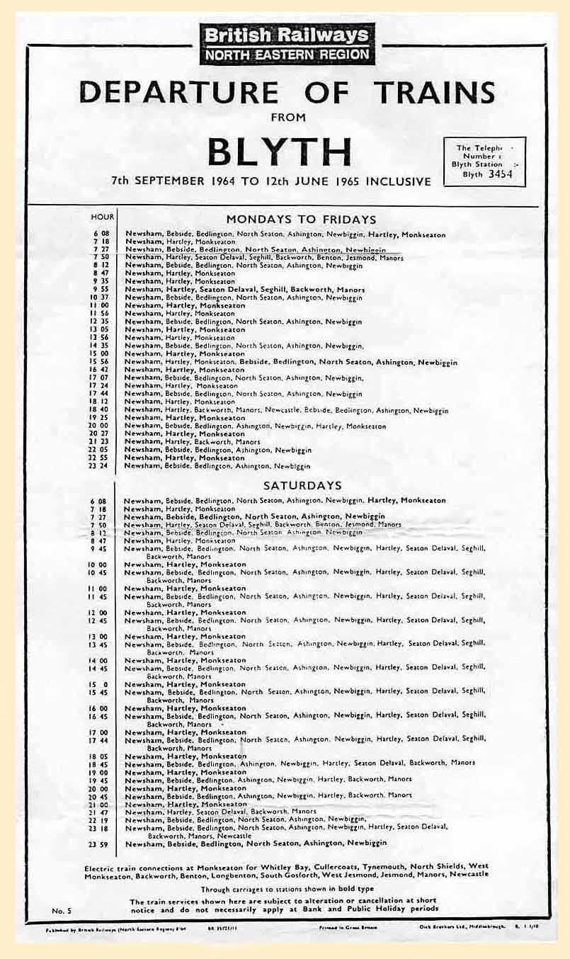
(Left) Another interesting item from Ed orwin's collection is this copy of the last winter timetable (7th September 1964 to 12th June 1965 inclusive). Now I can't think of any clever one-liners about the caveat on the bottom of the timetable, which reads - 'The train services shown here are subject to alteration or cancellation at short notice and do not necessarily apply at Bank and Public Holiday periods' - except to say that when this particular timetable was printed, Beeching's proposed closure of Blyth station had already been approved and despite fierce public opposition all passenger trains ceased just 11 weeks into the timetable. Ken continues below...
The Blyth and Tyne Branch Railway 2
by Ken Hedley
In 1958 the steam trains were replaced by DMUs and ran until 1964 when all services were withdrawn under Beeching, the last train ran in November of that year, leaving the branch then freight only, and complete closure of the Avenue branch followed shortly after.
Another line ran from Earsdon junction to Percy Main, where it connected with the North Tyne loop and was always freight only. This was worked on the permissive block system and was part of the original Blyth and Tyne railway, with connections to the docks on the north side of the River Tyne. In spite of the removal of the passenger trains, the branch was still a hive of activity with an abundance of goods and mineral traffic; there were connections into 22 collieries, both large and small, but all producing coal at this time.
The port of Blyth was biggest coal shipping port on the North East coast shipping 6,000,000 tons of coal at its peak in 1963. There was a total of 24 coal shipping points, 20 belonging to BR and 4 to the NCB with coal shipping staiths on both sides of the River Blyth. There were two steam sheds at Blyth namely North and South on opposite sides of the river, which supplied crews and locos for this work on a 24 hour basis. The locos were mainly ex-NER class J21, J25, J27 and Q6 - and at the latter end of steam, Class B1, K1 and Ivatt 2MT and 4MTs. The staiths were worked by ex-Blyth & Tyne locos rebuilt from 0-4-4T to 0-6-0T and classified as J77.
In 1959, a large power station was built on the north side of the river in two stages; first the 'A' station then the much bigger 'B' station. The demand for coal increased at the same time as the shipment of coal was reaching its peak, and this began to cause increased congestion on the branch by 1963. The withdrawal of the passenger service eased the situation somewhat, but still a lot of time was lost in transit; the decline in coal shipping started in 1964 and the gradual closure of the coal loading staiths began, first the South staiths in 1965, which meant all BR coal shipment being concentrated on the north side of the River Blyth. Then the North staiths closed in 1970, and the West staiths followed in 1983 leaving only one NCB coal shipping facility on the river, the coal coming direct from the colliery to ship. And when this closed, all coal shipment came to an end at Blyth.
All coal traffic was now concentrated on the power station and was transported by loose coupled trains of 21 ton wagons, but when dieselisation came this was changed to a merry-go-round system of 30 air braked large capacity wagons. In January 1968 both steam sheds were closed, and all work and personnel were transferred to a newly built diesel depot at Cambois (pronounced Camus) a half mile from the power station.
In the late 1960s, the coal trade began to run down and many smaller collieries were closed one by one, leaving the larger ones to supply the power station supplemented by coal from numerous opencast sites around the area, and later from collieries in the Durham coastal area. In 1970 Alcan UK Ltd opened an aluminium smelter and power station at Lynemouth, which was fed by coal direct from the colliery; the raw alumina is imported into Blyth harbour and transported by rail to the smelter. Alumina is also transported from Blyth to an Alcan smelter at Fort William in Scotland via Edinburgh, Glasgow and the West Highland line. The finished aluminium ingots were transported by rail for processing to South Wales.
In the early 1980s more collieries began to close and in the aftermath of the 1984 miners strike a gradual rundown took place. By the 1990s only a handful remained, but these were eventually picked off one by one, until only Ellington colliery remained supplying the Alcan smelter direct. All the rest of the Durham and Northumberland coalfields were now gone.
Finally, in 2001 the Blyth power station was closed due to lack of coal and today not a trace of it remains. The Diesel depot at Cambois closed in 1995 and the remaining men were transferred to Tyne Yard and various other locations. Then in 2005 the last colliery at Ellington closed which resulted in Alcan having to rely on opencast coal transported by road and supplemented by coal brought by rail from outside the area. Today the Blyth & Tyne branch like many others is but a pale shadow of its past, since all that remains is the Alcan traffic and coal imports from a new coal import dock built on the site of a former shipbreaking yard on the north side of the river. Today, all traces of collieries have disappeared beneath grassy hills and trees...
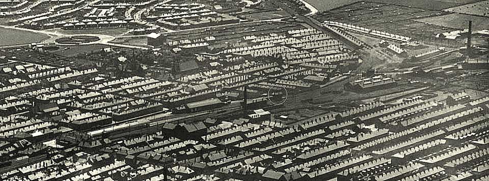
(Above) One of the joys of compiling this page is making contact with interesting people, particularly Ed Orwin who I arranged to meet at York station to peruse his archive of photos, architects plans and track diagrams of the station at Blyth - Ed is currently building a 'N' gauge model of the station. I can't believe we were there five hours - the time just flew by! One of the things that came to light is the importance of this photo. The signal box (circled) at the end of Blyth station platforms was elevated on a brick column and cantilevered out over the tracks to each side of it. During a bombing raid by the Luftwaffe on Friday 25th April 1941, the box received a direct hit which killed the signalman, John Hollon Elliott Norfolk, age 51 of 8 Railway Cottages, Bebside, who was on duty at the time as a favour to one of his colleagues. The signal box was never rebuilt - all its controls being handed over to the Renwick Road Crossing box, which ended up with special operating instructions right up to the closure of Blyth station in November 1964. The bombing raid caused a lot of damage to the surrounding railway infrastructure and many houses on the south side of the station were damaged beyond repair and subsequently demolished. It is said that a wheel set from a railway wagon was blown over the town into Ridley Park! Hearsay, me-thinks, even though Ken Hodgetts, a distant relative of mine, remembers his mother talking about 'the banger' that hit and the blast.
(Below) A classic study from Ed Orwin's collection of Class J27s being prepared for another hard day's graft at South Blyth shed.Built by the North British Locomotive Company Works No.18364 as NER No. 1029, in May 1908 she became LNER 5819. No. 65819 stands on road 1 and 65814 on road 2 of what was the first engine shed to be built at South Blyth. Both engines show their home shed as 52F. Withdrawn in October 1966 she was scrapped at Hughes-Bolckow, North Blyth in February 1967.It looks like a glorious day for a bit of light loco maintenance judging by the very relaxed ambience of the crewman here at South Blyth Shed. I would dare say by the length and direction of the shadows that it is early in the morning. You can almost smell the aroma of warm metal, grease, oil and smoke, and ash and coal; it is quite a unique smell, even pleasant - and the gentle simmering and hissing of the engines as they stand idle in readiness for another hard days work will rekindle memories for railwaymen and spotters.

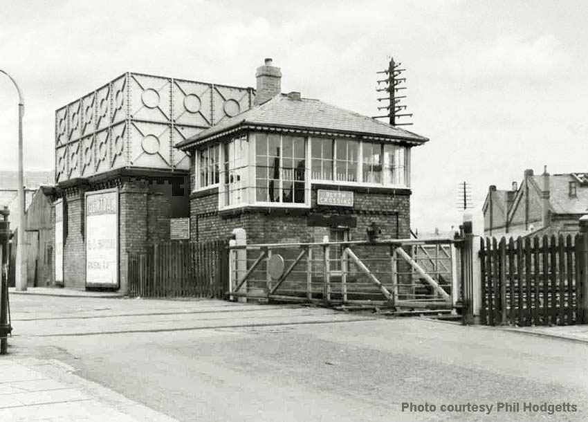
(Below and inset right) Cowpen Road Crossing and box. I remember the crossing being there, complete with gates and the rails across the road still in situ, seemingly awaiting the arrival of a train that never did come, but the crossing box and water tower were long gone. Beyond the fence on the right is the rear of the 6-road engine shed - and from this angle, between the crossing box and the shed was the turntable. There was short siding by the turntable where two huge NER snowploughs were kept. The billboards on the side of the water tower help date the picture. One is advertising Lonnie Donegan and Dickie Valentine in the 'Six-Five Special'. The show was based on the BBC's first rock 'n' roll programme, an innovated
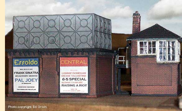 idea in those days - long before 'Top of the Pops' arrived on the scene - which was broadcast at five past six on Saturday evening. The 'live' show was launched on air immediately after the abolition of the 'Toddlers' Truce' - so-called because the BBC's television broadcast was closed down between 6pm and 7pm to allow parents to put children to bed. Disc jockey Pete Murray was its presenter, using the catchphrase - 'Time to jive on the old six five…'
 The show opened with action shots of steam trains accompanied by the show's resident band, Don Lang and the Frantic Five - 'The Six-Five Special's comin' down the line, The Six-Five Special's right on time...'
For more Fifties nostalgia click here to visit David Hey's page on 1950's childhood memories.
The film poster also features Kenneth More in the 1955 film, 'Raising a Riot' showing at the Central Cinema in Blyth. The cinema - or 'Flicks' or picture house, as most people called it - was built on the site of the previous Central Hall, which was destroyed by fire on 27th January 1923. The second billboard on the water tower is for the Essoldo cinema (see photo inset right of Ed Orwin's superb 'n'-gauge model of the water tower and signal box - the full layout is featured on the next page.
The billboard displays a poster for 'Pal Joey', a 1957 film loosely adapted from the musical play of the same name, starring Rita Hayworth (top billing), Frank Sinatra and Kim Novak. The film was a box office success and also earned four Academy Award nominations and two Golden Globe nominations. Many critics considered the film as the definitive Frank Sinatra vehicle, Sinatra won the Golden Globe Award for Best Actor for his role as the wise-cracking, hard-bitten Joey Evans. The Essoldo and Central were two of four cinemas in the town, the others being the the Roxy and the Wallow. The last to go was the Wallow in 2004, and Blyth has no cinemas today.
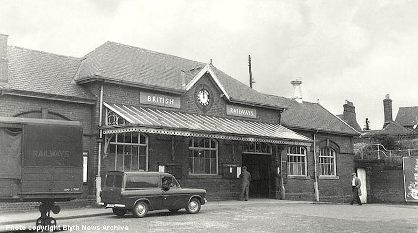
(Above) Blyth Station frontage in British Railways days. If only it was possible to identify the registration plate of the van. The reasons being, it would narrow down the date of the photo taken between the station closing on 2nd Nov 1964 and the introduction of Thames Anglia van in June 1961. There were two variants of van. The basic 5cwt model had painted bumpers and wing mirrors but the more upmarket 7cwt van had chrome bumpers and wing mirrors. Looking at the chrome hubcaps, it makes me believe that the van has white painted bumpers. They look white as opposed to greyish like the hubcaps. The number plate helps narrow things down a bit since the plates changed as of 1st January 1963 with the first 'A'-letter suffix. But at least we know the van type was introduced in 1961 and the station closed 1964. So as it is, the photo is more or less dated. (See Ed Orwin's comments about the actual date in the caption below) Note also the British Railways Scammel Scarab trailer on the left. Very common in their day across the whole country; the vehicles were used to transport goods and parcels to and from the station goods shed to businesses and homes in the town. The trailer was hauled by a three-wheeled tractor unit, and were renowned for their manoeuvrability and very tight turning circle - a versatile articulated vehicle in its day.
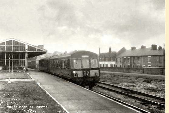 (Left) A DMU departs Blyth station on 12th August 1964. These Diesel Multiple Units replaced the push-pull steam trains that operated for many years on the line. The station had flower beds and grassed areas on the platform which can be made out in the foreground. And just in front of the canopy the name of Blyth was written out in whitewashed bricks on a flower bed, however in this view the station is not looking very pristine. The lamps only have their stands left and some tracks to the right have already been removed. Beyond the station canopy is the roof of the town's gas works and Delaval Terrace is on the right. The passenger service to Blyth ended on 2nd November 1964, with the last train leaving Blyth for Newsham at 11.59pm that Saturday evening.
 Ed Orwin writes: the photo was taken by the Blyth News official photographer on the 12th August to augment an article for that week's paper about impending closure of the line, a final appeal to keep the
 service open having just failed. Similarly, the station frontage (above) was also taken on 12th August, by the same Blyth News photographer, for the same reason.
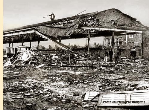
(Right) Demolition of the station in 1972. Not a scaffolding pole in sight! I wonder what today's Health & Safety Inspectorate would have to say about the chap throwing stuff off the roof into the back of the lorry? He's standing in such a precarious position! Among the youngsters looking on, is one chap to the right wearing an old Donkey Jacket with vinyl waterproof material across the shoulders - at the time a standard issue jacket for miners who had the joy of having NCB printed on the back. Don't see Donkey Jackets much these days now that I come to think about it. The lorry I believe, judging by the shape of the cab roof, looks very much like a Foden S21 tipper - affectionately nicknamed Mickey Mouse. Whether it is a three or four-axle lorry cannot be determined. Matchbox made a delightful little model of the lorry, and that thought has me ducking involuntarily just in case I get cuffed again!

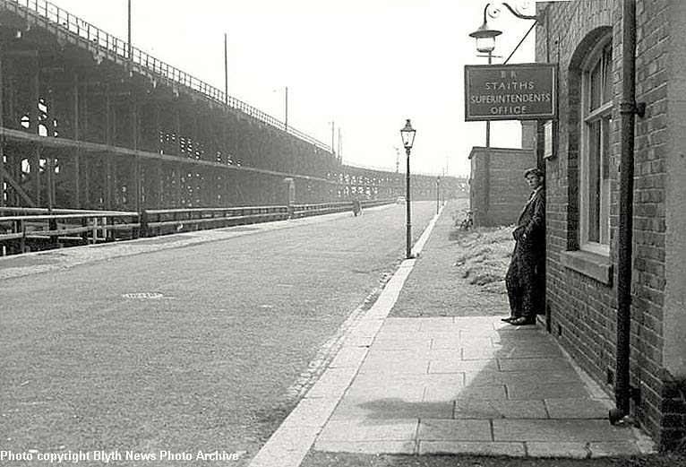
(Above-Below) Enlargement of the 1934 LNER map showing the position of the Spout Nos 1-8 on the South Side Staiths. (Below) This view looking south down Quay Road shows how the South Staiths looked from street level. The immediate thing that comes to mind is that the Supt's Office is now a British Railways (BR) Office. Straight away that tells us that the photo was taken after 1948 when Britain's 'Big Four' Railway Companies - Southern Railway (SR), Great Western Railway (GWR), London Midland & Scottish Railway (LMSR) and the London North Eastern Railway (LNER) - were nationalised by the Government. Prior to 1948, the LNER owned the Blyth staiths and trackwork. It is difficult to tell if there are any railway wagons or engines up on the staith, though in the distance a semaphore signal can be seen in the 'off' position, therefore the staiths must surely still be in use, and we are looking at a photo taken pre-1964. The other thing to note is the lack of motorcars or even lorries in the photo, while the gas street lamp is also of interest.
Like many towns, Blyth had its own gas works where Town Gas was produced from the burning of coal in the days before Natural Gas was discovered in the North Sea. I remember a man from the Gas Board coming to our little colliery row in the 1970s to convert our gas oven. The air-gas mixture for a good burn is very different between 'Town' and 'Natural' gas, therefore a huge conversion programme was carried out across the whole country between 1967-1977, in which every domestic and industrial gas appliance was converted. The Blyth Gas Works once dominated the town, but with the introduction of North Sea Gas the main plant was demolished, and the old gasometer (storage tank) used for storing the new natural gas.
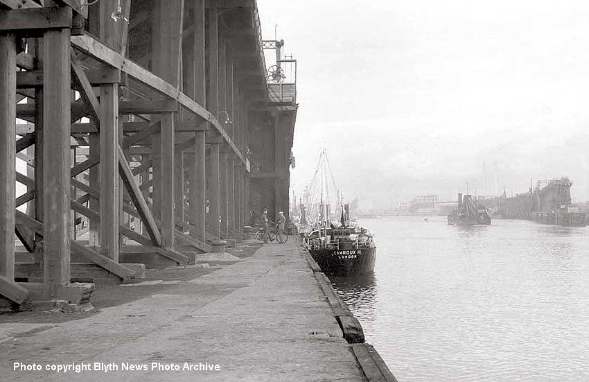
(Above) In this image we are looking north up the river, with our backs to the Pilots Jetty. Just to left through the timber structure is the southern end of Quay Road and the vessel at spout no 5 is Camroux III. There were 3 vessels in this class: Camroux I, II and III, which were nicknamed 'flat irons' on account of their bridges being just above deck level. This was to enable them to get under the bridges on the River Thames enroute to the power stations at Fulham and Battersea. As the eye moves away across the river we can see the dredger 'Cowpen' making its way upriver and to its right is the North Staith. Above the dredger in the murk can be seen the chimneys of Blyth 'A' power station, but once again the 'B' station is incomplete, there just appears to be a girder frame to the west of the completed chimneys so it places the picture about 1962. The two gentlemen by the spout are doing what comes naturally to North easterners and that is maim a donkey! - which, in case you're wondering, means talking the hind legs off of one!
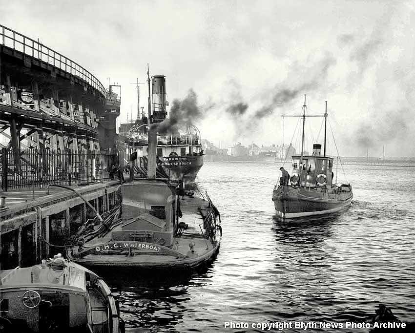
(Below) The photographer is standing on the pilots' jetty looking upstream and the vessel moored beneath No 1 spout is the 'Parkwood' of Middlesbrough. Note how its bow is quite high in relation to the stern - perhaps waiting for her next load of coal? Should this be the case then it dates the photo at pre-1964. In the foreground, the elderly BHC waterboat is attached to a hose, which might indicate it is an oil-fired steamboat taking on fuel? However, the deck is wet which suggests it has just been washed down, or, as the name implies, it is a water boat, and just that - a vessel used for replenishing the fresh water supply on ships waiting to be loaded in the harbour? The small boat to the right is called 'Cambois' and is about to moor up, with a crewman on the bow ready to tie her up. Looking into the distance, the Seven Stars pub basks in the sun across the river, and judging by the long shadows in the foreground it is late evening, which probably accounts for the relaxed ambience of the scene; a crewman can be seen propping up the rail on the right side of the Parkwood, while the black smoke belching from the stack adds considerably to the composition - this, for me, is one the best photos on the page…a great shot that might inspire an artist into producing a great painting.
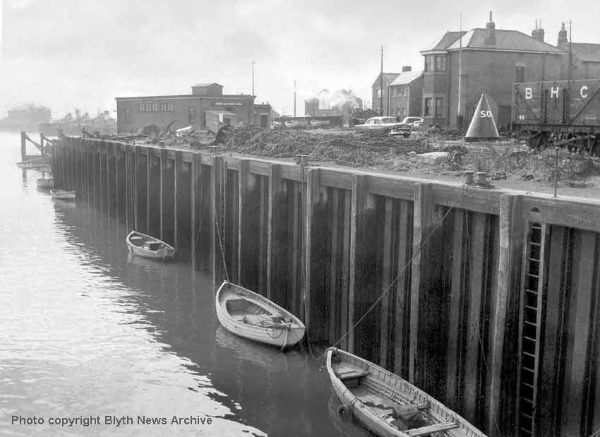
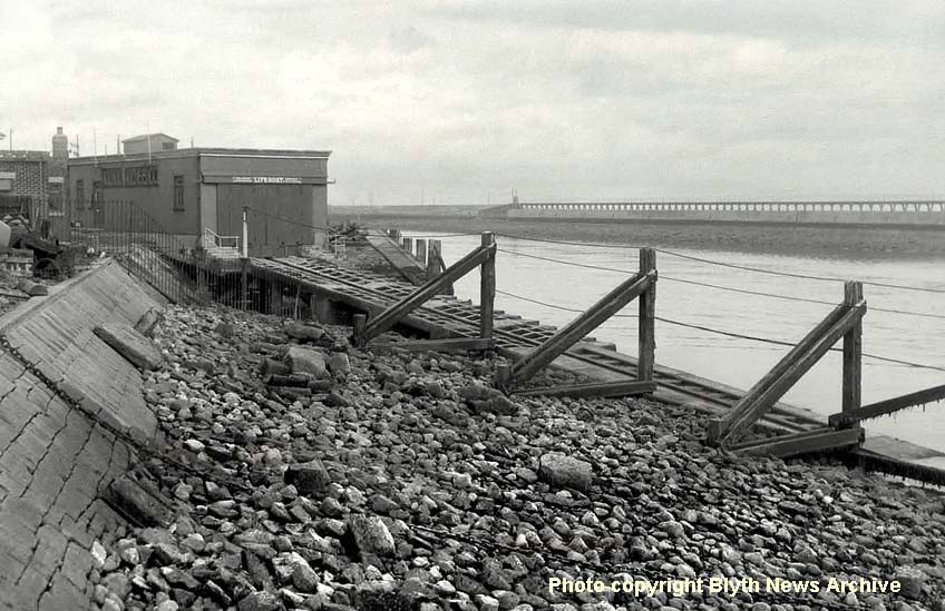
(Above-Below) The photographer has turned a full 180 degrees to take this view looking downstream. The boats in the water are called Foys: small flat bottom boats used by the Stevedores to move around the river to help moor ships at their berths. Fred Wagstaff relates the story of the time one of the boats was manoeuvring to take the mooring line off a ship, and the anchor was inadvertently dropped. It landed plumb amidships on the Foy boat, throwing the occupants up in the air and breaking the boat in two! However, neither man was injured but both were forced to retire to the Dun Cow pub to recover from their ordeal! Another point of interest is the big old American car, which I believe belonged to the photographer since it appears in several other pictures to be found in the Blyth News archive. It is a 1955-6 Chevrolet Bel Air - quite a status symbol and very unusual in a place like Blyth. Certainly it is a long way from home! To the right of the car is the conical-shaped Starboard hand buoy, so called because on the way into South Harbour it was kept on the right (starboard) of the ship, but on leaving harbour it was kept on the left side (port). There were two maker buoys either side of the entrance that indicated the navigable channel in and out of the harbour. The visible letters SO relate to the first two letters of the word SOUTH, which is written in full around the circumference. The Starboard side is marked green and Port side in red. In the background of the photo, the eagle-eyed might spot a steam engine working the headshunt of the LNER exchange sidings; also the rear of the Lifeboat Station can be seen in the middle distance - the photo (above right) shows the front view and slipway. Click here to read Blyth Lifeboat's well-decorated history.
(Inset Right) This a BHC's 0-4-0 saddle tank built by Hawthorn Leslie, which was delivered new to South Harbour in 1912. During almost sixty years of service with the BHC it carried the 'BHC no. 2' ID plates on its
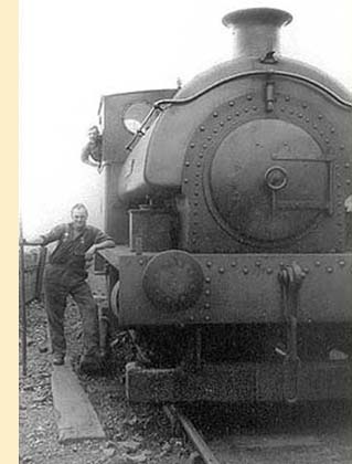 tank sides - No 2 being a replacement for an earlier locomotive. It was sold to the Yorkshire Dales Railway at Embsay for restoration in 1971. During its stay there it was named 'Pony', before being sold to the Chatham Docks railway in 1998 where it was renamed Achilles. It is currently going through another restoration at Chatham Dockyard Railway. Click here to visit the website.
 The chap sitting on the side of the locomotive is George 'Geordie' Wombwell, who was a fitter at the time the photo was taken; he later became Running Foreman with the opening of the Cambois Depot. One extra piece of information is that the smokebox door hinges and handles have been 'cleaned' by a chap at the shed named James 'Jimmy' Branley, who made it his own personal mission to do the task on some of the engines, though nobody seems to know what motivated him…it was just one of those quirky little deeds that folk turned their hands to!
I quite enjoy learning these little tit-bits; it somehow brings the old photos of Blyth back to life. This information was provided by my cousin Ken Hodgetts; I am very glad to have found out about Waggy, Ken Hodgetts and Ken Hedley - all of whom could write a book each.
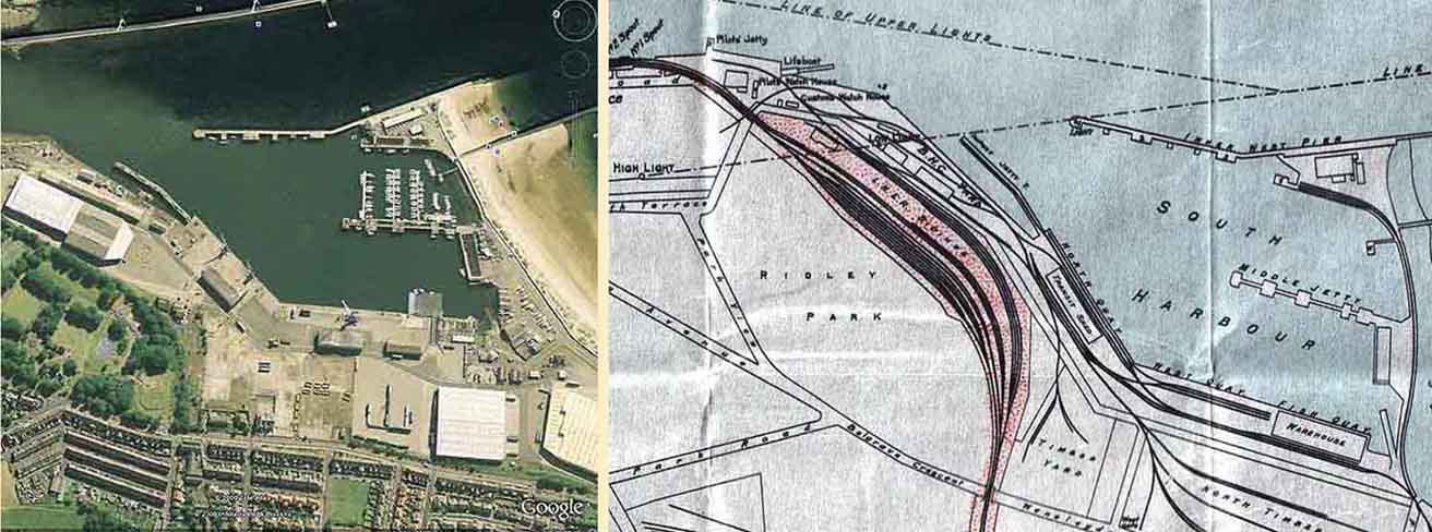
(Above) This splendid aerial view of Blyth South Harbour by Google circa 2006 is reproduced alongside a section of the 1934 LNER map and shows the network of lines serving the Blyth Harbour Commission's (BHC) harbour and timber yards.
The South Harbour at Blyth was a very busy place. Initially, the harbour was completed 1899 and used for ships that were queuing for access to the various staiths along the river. At times, so many ships were waiting, that navigating the river was nigh impossible. The South Harbour was created to hold waiting ships so that they would not encroach on the navigable channel. The opportunity was also taken to use the South Harbour for developing other business.
(Below) In this early view of the South Harbour (two images 'stitched' together in Photoshop by David Hey) was taken from the top of the High Light circa 1903 looking south, the great expanse of the harbour can be clearly seen. Work is taking place on the East Pier extension on the far left, the Inner and Outer West Pier can be clearly seen along with the mouth of the river. There are a number of vessels moored on the Middle Jetty and over on the right under the arc of smoke and steam given off by the locomotive can be seen the purpose built 1902 Lifeboat Station and the Rushford Shed next to it. There are no signs of the West Quay and Fish Quay though it appears that there are pile drivers at work on the water's edge just beyond the signal box. There are no Harbour Commissioner's buildings. The hard working steam locomotive and the host of full and empty coal wagons suggest that the staiths were busy as ever with the export of coal from the town. Also of note is that Ridley Park was not completed at the time this photo was taken. The Park House date stone is 1903.

Effort was made early in the 20th century to develop and expand the fishing industry at Blyth which had a faltering start in 1880 and never really developed into a thriving trade, perhaps because of the close proximity of the fish markets on the Tyne. As can be seen in the next few scenes though, Blyth did indeed become a very busy fishing port. In the year 1912 The Port of Blyth Fishing Co. was established and much
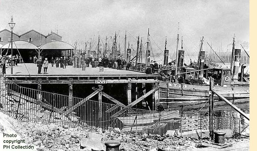 effort was put into developing the fishing trade and of course capturing and processing the lucrative herring industry. Ice houses were built along with plant and machinery shops for processing the fish.
(Inset Left) This next scene is of the Fish Quay and its associated buildings in the background. This photo was taken from the top of the 1902 Lifeboat House ramp, which at that time (1902 - 1921) housed the 'DASH'. The date is circa 1912-14. A very different scene from what appeared to be a barren waste in the previous picture. Little needs to be said as it is obvious just how busy the harbour was with fishing boats, all steam powered rather than sail. Wonderful to see all the people on the harbour side, one of them a woman in long skirts with a bright white apron protecting her clothes no doubt from the wet fish and melting ice. I'd be very interested to know where the various vessels were from. The first in the line
 appears to be KY118. I can also see A769, perhaps Aberdeen? It looks to be a nice day for Blyth given how quiet the surface of the water is and the shadows cast by the street lamp and the people on the quayside prove that the sun was for once shining brightly.
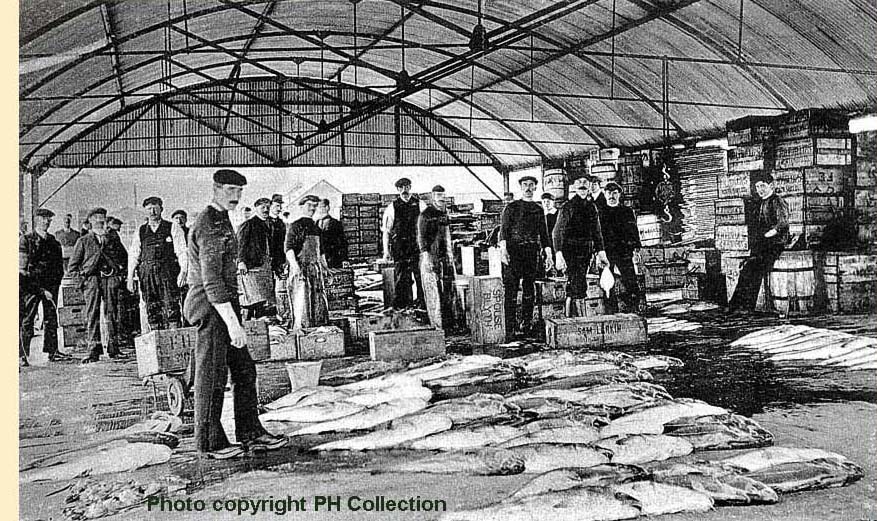
(Inset Right) The barrel roofed sheds we saw in the previous picture were where the fish auctions took place. This picture illustrates nicely the activities that took place under the cover of those rooves. Just look at the size of those fish! Names on the fish crates that can be seen are Spouse of Blyth and Sam Larkin, though I cannot identify where he was from on the crate side.
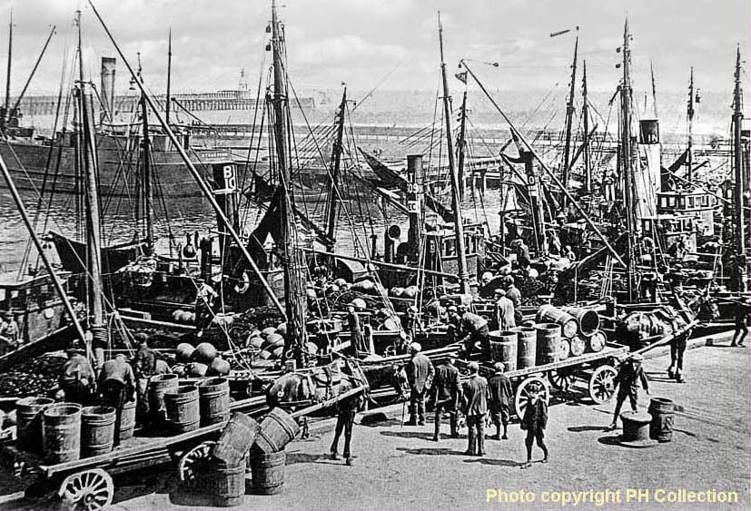
(Below) Another image taken about 1912-14 gives us a broad view of the South Harbour. A collier can be seen waiting close by the Middle Jetty. Note the harbour entrance beyond. The East Pier lighthouse was opened in 1907. Here, again, we can also see the original Outer West Pier which was also known as the 'Training Wall'. Today, a lone navigation light stands where the end of this original pier was. I had thought that the 'Training Wall' was some sort of facility for training crew, but it was for 'training' the river. The harbour entrance suffered for many years with a build up of sand across the mouth of the river which was difficult to keep clear, so the Training Wall was constructed in such a way as to encourage scour on the outgoing tide. The flow of water prevented the build up of the sand bar across the harbour mouth. One lives and learns! Looking at more of the funnels on the trawlers, I see IN, so assume Inverness. Interesting to see the main mode of transport in those days was the trusty horse and cart. Whilst listening to a television programme about the Edwardians, I heard it said about this time prior to WW1, there were about 15 million horses in Britain! The population of Great Britain and Ireland in 1911 was just over 45 million, so there was one horse for every three people. It always amazes me to think how women wore such long skirts in those days, given the amount of horse muck that there must have been in the streets, one would have thought it more practical to wear their skirts six inches shorter at least!
(Inset Left) Of course given how busy it was when the herring catch was landed, we cannot forget to mention the women and girls that travelled huge distances during that three month period, to assist with the processing of the catch and the packing of it in barrells. A fascinating subject in its own right, they
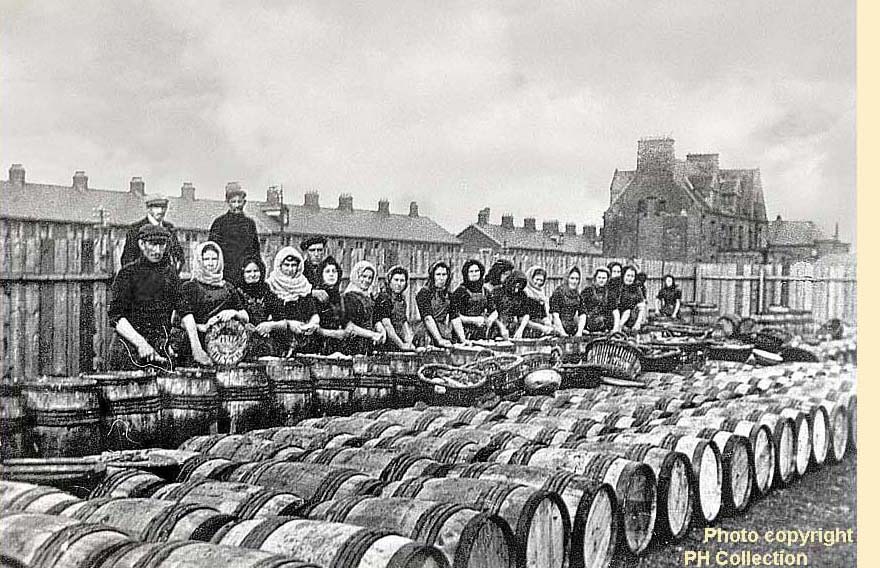 were indeed tough, formidable women. I don't suppose they would notice the smell, but I'm guessing that the young men 'zooming' the girls of that era would be able to tell a herring girl from any other girl at a thousand paces!
The fishing industry in Blyth, despite that period of intense activity, was in reality quite short lived. No doubt the people captured in these photos would have been keeping abreast of the news and the ever growing concerns and the eventual announcement of war against Germany in August of 1914. The fishing fleet in Blyth was requisitioned by the government, the ice houses dismantled and the machinery sold. The South Harbour was put into use as a submarine base for the war effort, Blyth being ideally situated for access into the North Sea. After the war was over, there was virtually nothing left of the fishing industry in Blyth and sadly Blyth never again saw the levels of trade it benefitted from prior to the war. Wensleydale Terrace and the Ridley Park Hotel are the buildinsg which can be seen in the background. The hotel is about to be consigned to the history books as it is earmarked for demolition as at January 2013. Bought by the Port of Blyth, the site will be cleared and redeveloped for use by the Port.
(Below) Another example of David Hey's Photoshopping handiwork...the 1934 map has been superimposed over the Google image to illustrate the extent of trackwork in relation to the present day. Click on image to enlarge, then click again to see full size.
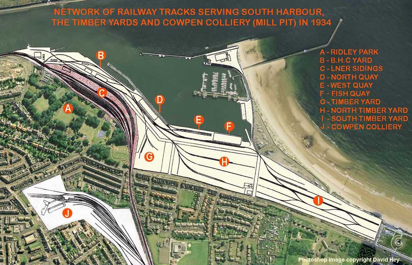
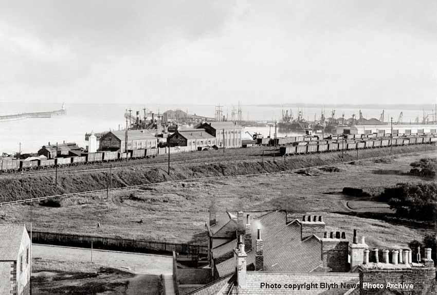
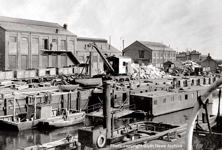
(Above-Below) The top photo was taken from the Blyth High Light behind Bath Terrace (the structure is featured at the top of the page). The grassland in the foreground is part of Ridley Park, which opened its gates in 1904. Beyond the railway sidings is Blyth South Harbour established in 1881, and on the extreme left of the harbour can be seen the BHC's single-road engine shed and a tall white hexagonal structure called the Low Light: a navigational aid used by ships approaching the harbour at night. Click on the 1934 LNER map (above right) showing the position of both the Low and High Lights, which, in conjunction with illuminated red and green navigation lights, provided a safe entrance to the river and harbour.
Among the Blyth Harbour Commission's buildings in the distance is a steam crane, which leads us onto the photo (below) showing a closer view of the railway crane operating on the quayside. On the extreme right is the front of the engine shed, beyond which is the Pilot's Watch-House and Customs Watch-House, and just visible in the distance is the south staith (the eagle-eyed might even spot the rear of a Class J77 0-6-0T). Berthed amongst the motley collection of vessels in the dock is the vehicle and passenger ferry that operated the High Ferry crossing point from 1924-1964, hence it dates the photo at a time when we can be certain the little saddle tank BHC No. 2, built for the BHC in 1912, will be about somewhere. There is a lot of activity in yard, though it looks very cluttered - 'ship shape and Bristol fashion' it most certainly is not! The pile of rocks to the rear of the steam crane is pale in colour suggesting it has recently been quarried. I wonder if the rocks were to be used to strengthen the harbour or pier walls, or perhaps repair storm damage? As is usually the case, when you study the detail of a good quality photo it raises lots of questions…
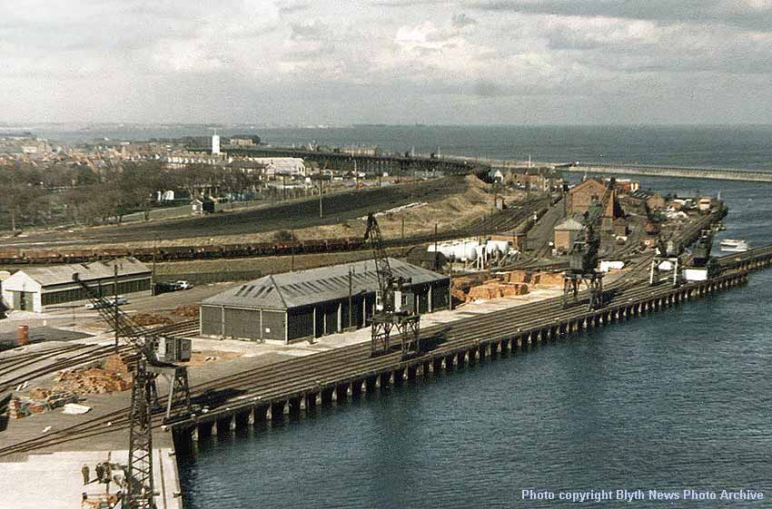
(Above) My first impression of this shot is that the cameraman must've had a good head for heights! This photo was taken from the boom of one of the West Quay cranes and gives a wonderful perspective of the various levels of trackwork that are not apparent on the 1934 LNER map. On the North Quayside, just above the Transit Shed roof, a rake of wooden bodied wagons are standing on the gradient leading down to the BHC exchange sidings, and just above them are the empty LNER sidings, a large section of which is already devoid of rails. This gives us our first clue as to the date of the image. It must be 1965-66, just prior to the demolition of the South Side Staiths. Today the High Light is the only distinguishing landmark that remains, which seems to stand guard like a vigilant watchman observing his domain.
 It is hard to imagine how the landscape must have looked when the tower was first built close to the waters edge in 1788 - the extent of land reclamation is plain to see in this photo. But then it is sad to see that there are no rail wagons at all on the rusty rails serving the North Quay and the five cranes are standing idle. The BHC yard looks quiet too; we can just make out the engine shed and just beyond that the 1920 lifeboat station with its white doors. Between the Lifeboat Station and the South Side Staiths are the Pilots, Customs and HBC offices - and along the staith we can make out spouts 1-4.
Today, of course, besides the odd few buildings, the whole area here has changed; even the railway embankments have been removed for the construction of modern warehouses. If it weren't for the evidence in old maps and photos such as this, it would be hard to grasp the full extent of trackwork that once served South Harbour. The railway was a major feature of the Blyth landscape for decades. Even the timber yards to the south have gone, albeit the area is still used for storage and distribution by road transport and touring caravans are stored in the southern most timber yard. But at the time this photo was taken, we have to bear in mind that it was not long after the Beeching Report was published in 1963, and the closures notices that were proposed had a massive impact on railways across the whole country. The town of Blyth became a major victim, not only losing its industrial railway, but also its passenger services in 1964.
However, in the not to distant future, it is hoped that the railway will make a comeback to Blyth, especially in view of the town's rising population along with that of Ashington, besides which there are potential rail commuters living in many other smaller towns and villages along the Blyth & Tyne route. It has always surprised that the Metro was never extended northwards into the area using the existing network of railway and trackbeds that are available. The area is well suited for a light rapid transport system that could be extended from Whitley Bay up through Monkseaton onwards to Newsham, Bebside (for Blyth park and ride next to Spine road) Bedlington, Ashington and Newbiggin. There is no reason why this service could not be operated on the same lines as the Metro route to Sunderland and South Hylton; perhaps the tracks could be shared with heavy rail? Who knows what the future might hold? One thing for certain, though, road traffic in and out of Newcastle is increasing at an alarming rate and the city is already get gridlocked during the rush hours. In my view, the redevelopment of the railway is long overdue - an alternative form of transport is desperately needed…
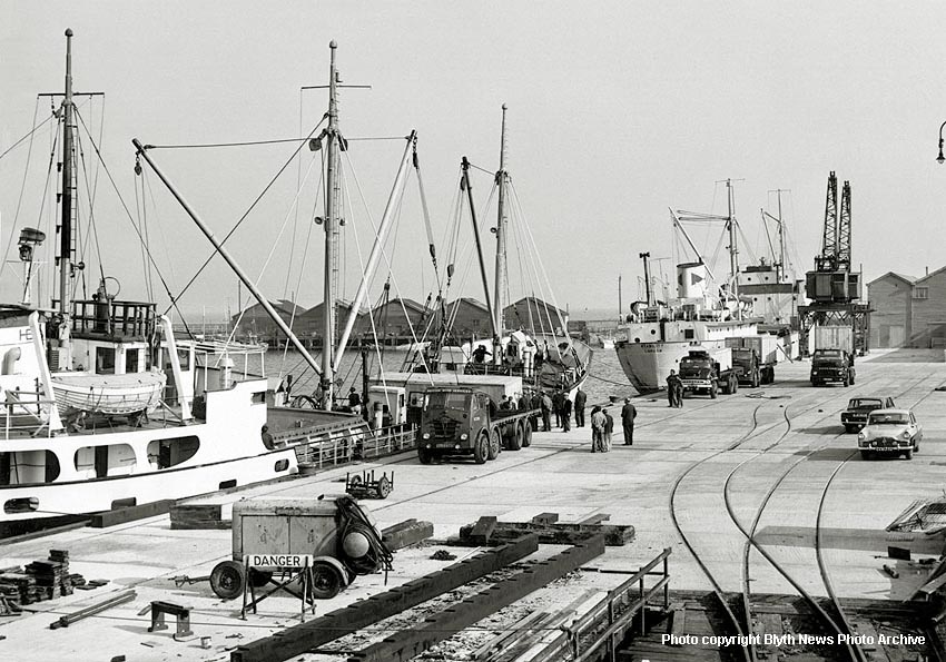
(Above-Below) Another excellent detailed photo of South Harbour, this time viewed from West Quay looking towards the Fish Quay, though it's not an easy photograph to date. The Triumph 2000 (dark coloured car facing away from camera) is a MK1 first introduced in 1963. It has 7 digits on its numberplate - the first 'A' suffix registration was introduced in 1963, the same year as the car. So it might well be an 'A' registered vehicle; it certainly has a suffix letter. The Ford in front of it is a Zephyr MK2, which was in production from 1956 to 1962. The lorries in the photo are in the bright red British Road Services (BRS)
 livery (circa 1950) and the one on the left is a Foden type FG 8 Wheeler, a popular lorry modelled by Dinky and Corgi Toys. The next lorry on the harbour side is a Thames Trader and behind that is another British Road Services Leyland Octopus/Beaver. The lorry on the right is also a red BRS vehicle and is in the shape of an Albion Reiver, but it clearly has Leyland written across the bonnet so it is most probably a Leyland LAD which came from the amalgamation of Leyland, Albion and Dodge over a ten-year period. The compressor in the foreground looks as if it is being used in the repair of some wooden structure, probably a section of the staithes or a part of the docks or dockside buildings. All the concrete looks very new and white so it cannot have been there for long. Everybody seems to have abandoned work to watch the lifting of a huge wooden container box lying across the ship already attached to two of the ships cranes…the crane cables are very taught, suggesting the box is about to be lifted onto the Foden truck. I don't know about you, but it looks a rather BIG box for the truck…wonder what today's Health & Safety Executive would make of it? All the details in the photo offer clues to the date, and in particular the absence of rail wagons in the picture suggest it is 1963 or soon after. Certainly it is pre-1970. (Below) Turning away from the BHC yard this is the view looking south. The cranes on the left are operating on the north quay and the transit shed dominates the centre of the scene.
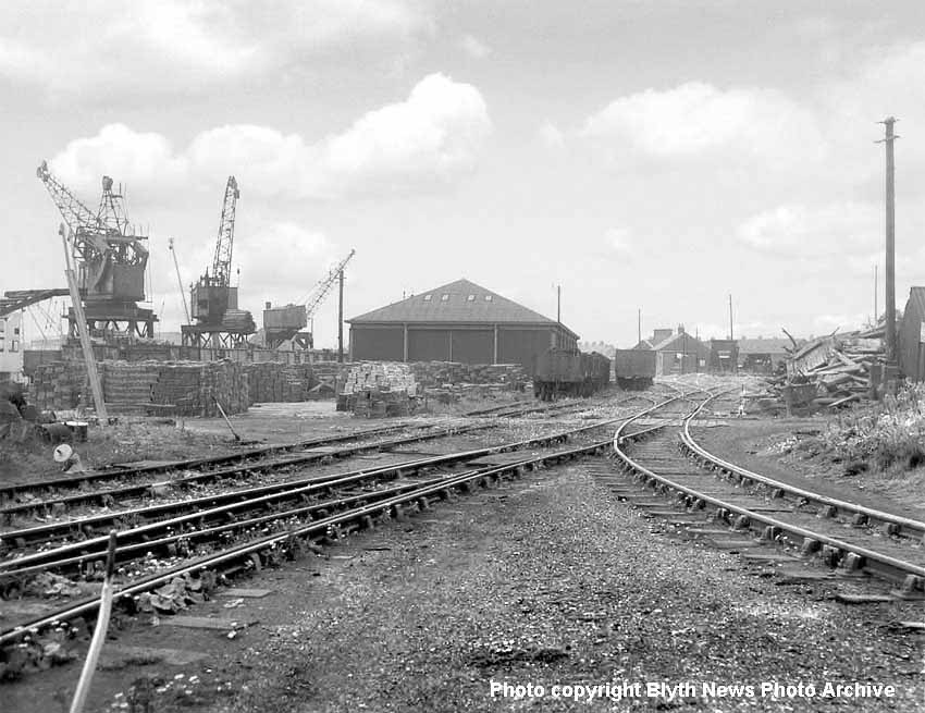
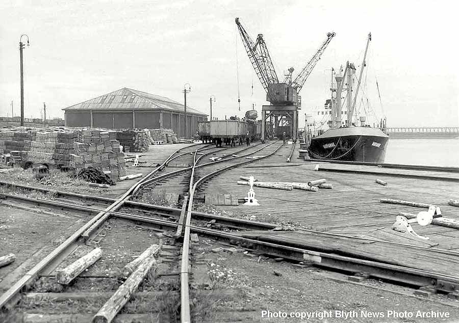
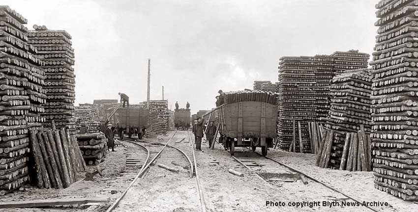
(Above-Below) The photographer has continued his walk past the transit shed, turned 180 degrees and photographed this view from the rail crossover adjacent to the west quay, which is just visible on the right. We are now looking north along the north quay. The name of the vessel cannot be made out, but it is delivering pit props imported from Scandinavia. Looking at the cranes a huge bundle of props are being lowered into a railway wagon. It is interesting to see the pit props carelessly discarded along the quayside and the track - potential hazards for Health & Safety men to get worked up about! On the horizon, beyond the large stacks of roof tiles are the exchange sidings. The large building is the transit shed, which obscures the view of the BHC yard beyond. The South Timber Yard is where countless thousands of pit props were stored - beautifully stacked like Gulliver's matchsticks by the little people. Quite a sight to see the men manhandling what are in reality tree trunks. Thousands of tons all moved by hand; no forlkift trucks in sight. Both photos are very difficult to date. The only guidelines are the rail wagons, but both styles - metal and wooden - were in use side by side for many years. I recall hot summer days when dad took us to the beach, and as we passed the huge stacks of timber I never once gave it a thought. But the Mermaid Cafe and ice cream was the only thing I had in mind!
Polite notice: All text and photographs are protected by copyright and reproduction is prohibited without the prior consent of the © owners. If you wish to discuss using the contents of this page the email address is below. Please note - this is not a 'clickable' mail-to link via Outlook Express. You will have to email manually.
philiphodgetts@aol.com
dheycollection@ntlworld.com


