Introduction by David Hey
Philip Hodgetts recently contacted the site to comment on Fred Wagstaff's memories of North Blyth Steam Shed and Cambois Diesel Depot. Phil's quite obvious enthusiasm for Blyth is infectious - his love of the Northumbrian town shines through, and so I am pleased he has agreed to input his childhood memories on this site. Although Phil was born long after Blyth's heydays as a major port, his research into the compilation of this page has been an interesting journey for him - and a most rewarding one for the both of us. Indeed, it is encouraging to find a relative youngster (Phil was born in 1968) doggedly determined to investigate Blyth's place in history and share it with others. The page has grown from a tiny seed of an idea based on a superb 1934 LNER Plan of Blyth that Phil purchased on eBay (see below). Perhaps some readers may find a few inaccuracies along the way, therefore if you wish to discuss the contents of this page, Phil's email address is at the bottom of the page. Meanwhile I'll let Phil take up the story...
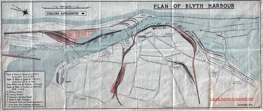
(Above) This is the 1934 map of LNER-owned property around Northumberland's Blyth harbour and river. The LNER property is marked in red whereas other private railways have no colour. The map itself is quite fragile and it is printed on what I can only describe as greaseproof paper. The map is not on the usual alignment since the North is off to the left in the top left corner of the map. Therefore, working our way from left to right (north to south) we have initially the West Staith (with spouts 17-20) protruding into the River Blyth on a more or less north-south alignment.
To the north of this staith was a large selection of LNER sidings but for some reason they have not been included in this map. However, the map does show the village of North Blyth with the vast array of sidings that were used to shunt loaded coal wagons out onto the North Staith (spouts 9-16) and return empties. The sidings also had a connection into the Hughes Bolckow breakers yard, which can be clearly seen on the map, along with North Blyth Engine Shed (52F) opened in 1897. The Cowpen Colliery Railway (Cambois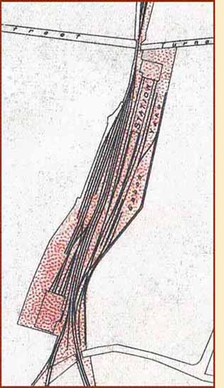 Pit Branch) is shown passing by the sidings along the shoreline to the private staithe of Cowpen Coal Co. spouts 1-4.
On the South Blyth side of the river (again starting from the left and norh of the town) we have the Cowpen Colliery (Bates Pit) complex of trackwork including their own staith. Moving south we have the original Cowpen Quay, which became the Cowpen Dry Docks, which also had two shipbuilding slipways.
Blyth Station is prominent in the centre of the map, with the South Staith heading out past Low Quay and Quay Road (with spouts 1-8) before turning away from the riverside through the mass of sidings adjacent to Ridley Park from which access could be gained to the Blyth Harbour Commission's network of lines serving the various quaysides and timber yards to the South.
The LNER then heads away from Blyth past Cowpen Colliery (Mill Pit) in a southwest direction back to Newsham (pronounced News-um) Junction.
The aim of this page is to break the map up into sections and attach old photos taken at various points along the way so that a visualisation of the harbour and rail network can be built up in the minds eye. It hasn't proved to be the easiest undertaking, but for those of you who are old enough to remember Blyth Harbour in its heyday, and have arrived at this page by looking up the town on the web for old time's sake, it might rekindle memories of an era long since consigned to history.
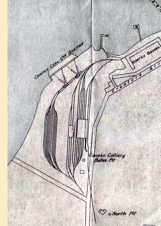 (Above & Right) An enlarged section of the 1934 LNER map showing the lines serving Blyth station, along with the goods yard and the six-road South Blyth engine shed. Although the coaling stage and turntable are not shown, it is clear from the track plan that it would make a wonderful prototype for a model railway layout, since there are various options for a fiddle yard - or even a continuous circuit that includes the South Side Staiths. Get out the balsa wood! - or if you're an N-gauge modeller matchsticks will do, if you're dabbling in Z-gauge the best of luck! (Above Right) Track plan of the Cowpen Colliery Bates Pit - an aerial view of the West Basin showing the siding serving Bates Pit is featured further down the page.
(Below Left) There is one non-railway feature on the map that jumps out at me immediately. It is the convergence of roads known locally as the Broadway Circle - a crossroads prior to 1924 before the roundabout was built and planted with trees. As a boy in the mid 1970s, I remember a family friend called Dennis, who was teaching his wife Betty to drive. On approaching the roundabout, he instructed her to go straight across - and so she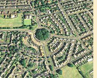 did! Taking Dennis at his word and yielding to no one, she mounted the kerb and drove straight over the island at 30 mph! Arriving at the other side she swerved oncoming traffic, before a shocked Dennis told her to pull over and asked why she had done such a thing, to which she replied - 'But you said go straight across!' - and, undeniably, he had. Dennis didn't have a leg to stand on! Needless to say, it was the last time he took his wife out in the car, but after a course of driving lessons she did pass her test eventually. Good old Betty!
Many other childhood memories have been sparked by finding such familiar places on this old LNER map. I didn't think I'd have much to say, or be able to add any more to what has already been posted on the web about the history of Blyth, but David has cajoled me (bullied me, more like) and having studied this map I am at a loss for words, in the sense that I now have too much to say! Where to start? Perhaps I should begin by describing how this map has reignited my passion for my old hometown of Blyth. I was born in Ashington in 1968 and brought up in the village of Cowpen, pronounced 'Coopen' - I should point out that cows are not cows in Geordie-land, they are 'coos'.
Cowpen is situated on the outskirts of Blyth, and I had the privilege of having a whole host of riverside fields to play in during the long summer holidays; sadly most are now buried under industrial development.
On seeing the network of lines serving the West Staithes at Cambois it immediately sparked memories of class 08 diesel shunters creeping out onto the long wooden structure with rakes of coal wagons. The coal was dropped into ships bound for all manner of destinations; often heading for Portugal and Ireland besides cities in this country such as London. Vessels arrived from the Baltic and Scandinavia, all of which made me wonder where in the world these places were, and as a small boy it gave me a hankering to go to sea.
Blyth was very much past its best when I was growing up. The huge staiths in the town were gone, cropped down to their current level in 1966-67. All the staiths - barring the West Staith - ceased to be used in 1964 and after a few years lying out of use, they too were demolished before I was born and of an age where I could fully appreciate the importance of Blyth as a port and its place in history.
 (Left) This is me on the far left, bottom row in the Class of 1973 at Bebside Infants School. I was a happy little chappie then, just 5 years old.
Incidentally, Cowpen had various spellings since the name was first recorded. It was spelled Cupum between 1153-1195, Copoun by 1250 and then from 1271 to 1346 it was spelled Copun. It became Coupowne in 1428, then Coopon in 1560 until by the 19th century its present-day spelling Cowpen was established. It is believed the name Cowpen originates from an Old Norse-Scandanavian word 'kupa', which means cup or bowl. The word is also used to describe a cup-like depression or valley in the ground, and this might well make reference to the earliest saltpans in the area. The word 'kupa' also has connections with the Swedish 'kupa' meaning a small cottage or household. So both phrases 'at the hollows' or 'at the cottages' have relevance.
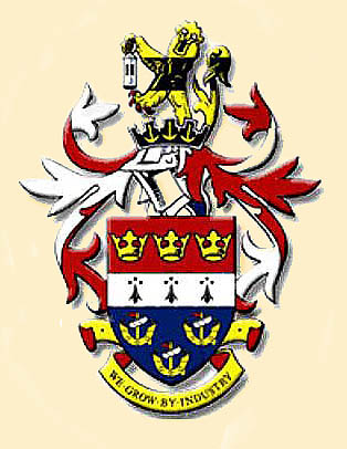 (Right) The Blyth Valley Council's heraldic insignia was first granted in 1922. The arms are based on those of the Borough of Blyth. Each emblem on the shield is displayed in triplicate to commemorate the three former authorities that merged into Blyth Valley. The three crowns at the top of the shield are from the arms of Tynemouth Priory. The ermine bar is derived from the Delaval family arms. The ships in base represent the Port of Blyth. The crest is a lion holding a miner's lamp. The gold lion comes from the Northumberland County Council arms. The black stripe suggests a seam of coal. The motto 'We Grow By Industry' is nice and succinct - if only it was true in today's economic climate, but quite the opposite is the case…
I went to Bebside Infants followed by Bebside Junior and Bebside Middle School. At the Middle School I was taught geography by the formidable Mrs Law - I am still having therapy 30 years later!
In spite of her domineering presence, however, she instilled in every youngster the importance of Blyth's long history going back many centuries. We learned that between the 12th and 18th centuries several small settlements had been established in the area, the principal industries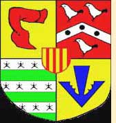 being coal mining, fishing and the salt trade. As far back as 1138, monks from Newminster Abbey near Morpeth exported salt from the pans on the north side of the River Blyth. This was influenced by a copious supply of local coal for use in the evaporation of the brine. Shipbuilding in the area dates back to 1748, and much can be found out about Blyth and its history as far back as Neolithic times on the web, so I will not dwell on it here.
That said, whilst researching online, I came across several sites covering Blyth's history, but in particular I enjoyed reading Fred Wagstaff's memories of North Blyth Steam Shed and Cambois Diesel Depot. After contacting David and showing him the LNER map of Blyth Harbour, we decided between us to share a collection of old photographs of Blyth, which, in some instances may have been published before - but when pieced together with detailed sections of the map it is hoped they provide a pictorial history of the town long since gone.
(Below) The power station and Bates Colliery were the predominant things we could see from the bedroom window at the back of our house in Cowpen. We were fortunate to have lots of open fields to play in and the river too. In the second aerial shot below, you will see a small inlet to the river on the left edge of the image. The fields around both sides of that inlet used to be my playground. Now the majority of the area is built upon with industrial units and factories. I have vivid memories playing in those fields as a boy, and in particular I recall watching the Vulcan Bombers 'homing-in' on the Power Station chimneys during practise bombing runs from their Lincolnshire bases. They used the chimneys as a 'target', and once they had achieved their 'goal' and turned back out to sea, we had a spectacular view of the aircraft's belly and the vast Delta wing shape. Then there was the huge roar of its engines which left an indelible impression on this impressionable youngster. Little did I know what the planes were actually doing...I'm harking back to the Cold War years, and it still gives me goose pimples today to think that we grew up during a period of East-West hostilities and the threat of Nuclear Armageddon without fully understanding anything about it as a child. The Cold War ended in 1991 - or did it?
Compiling this page has been a fascinating journey down memory lane for me. The collection of pictures bring back memories of familiar sights and sounds as well as smells in some instances. The roar of the power station when they were venting steam...a sound that could be heard miles away; the winding gear of Bates whizzing around, and at night when my sister and I were supposed to be sleeping, we could easily read in bed by the lights blazing from the colliery. That was until mum and dad found out, and then we ended up with an old blackout curtain pinned across the sash window; even the light bulb was removed from its fitting - 'The purpose of bed is to sleep!' was the mantra. It reminds me of my excitement at bedtime when mum announced it was time for the 'blanket show!' I was, of course, expecting Punch and Judy or some such thing, but it turned out to be bed...and her so-called 'blanket show' did not hold its allure for long!I hope you enjoy visiting this page, even perhaps if you found it purely by accident whilst browsing the Web. The page is bound to evolve has time goes on.
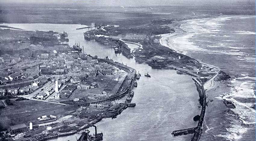
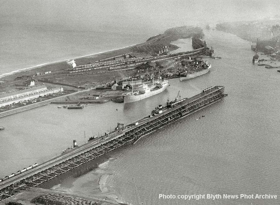
(Above) This interesting aerial view of the port was taken in pre-power station days, which is the first thing to note, hence it dates the photo at pre-1955. The Cambois tidal basin is there, therefore the photo is dated post-1934-5, however the housing estate close by Cowpen Square is not yet built, which narrows the search further to 1934-1939. The tall white structure left of lower centre is the Blyth High Light on Bath Terrace; a prominent feature of Blyth since its construction in 1788. Two other stages of heightening took place in 1888 and 1900, which raised it to its current height of 61' 6". Surprisingly the High Light used to be on the waterfront, but now it stands over one hundred yards away from today's shoreline! It was deactivated as a navigation light as late as 1985 just short of 200 years of service.
There are ships berthed at many of the staith's spouts. On the left side of the river at the South Staiths there are vessels at spouts 1,2, 3 & 4 and further up on Cowpen Quay is a large vessel, perhaps having repairs made, as it is adjacent to Cowpen Dry Docks and Shipbuilders. Above that vessel and on the north side of the river in the distance can be seen the West Staith too far away to make out any vessels.
However returning down the east side of the river we can see vessels on the North Staith from spouts 16 through 9, even a wisp of smoke or steam from an engine on the staithe top. No vessels seem to be at the Cowpen Coal Co's staiths. One other point of interest is that the East Pier has been extended. I understand that the pier was extended in 1907. The Seven Stars public house can also be seen on the east side of the river. Returning to the bottom centre left of the image we can just see the steam packet dredger 'Cowpen', a bucket dredger, which arrived at Blyth in 1913. The vessel clanged and banged its way around the harbour for 51 years, clearing an estimated 15 million tons of spoil to keep the channel at the correct depth. It was eventually sold to Italian owners and left Blyth for Naples in 1964, its duties being taken over by the new suction dredger 'Crofton'. To the left of the dredger can be seen Blyth Harbour Commissions' yard with the white Low Light, which provided navigation aide along with the Highlight.
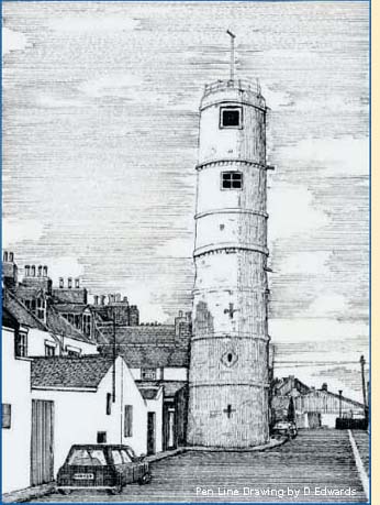 (Left) The Blyth High Light (lighthouse-navigation point) is situated just behind Bath Terrace, and is one of Blyth's oldest structures.
Built in three stages, it stands at 18.74 metres (61.5 ft) tall. The first section was constructed in 1788 to a height of 10.66 metres (35 ft) while a further 4.26 metres (14 ft) were added in 1888, followed by an additional 3.82 metres (12.5 ft) in 1900.
It was deactivated in 1985 and listed as a Grade II building on 15th July two years later. It is amazing to think that this building once stood on the foreshore! The pen line drawing is by local artist, Dave Edwards, who has several artworks of Blyth featured on his 'Blythart-Redbubble website.
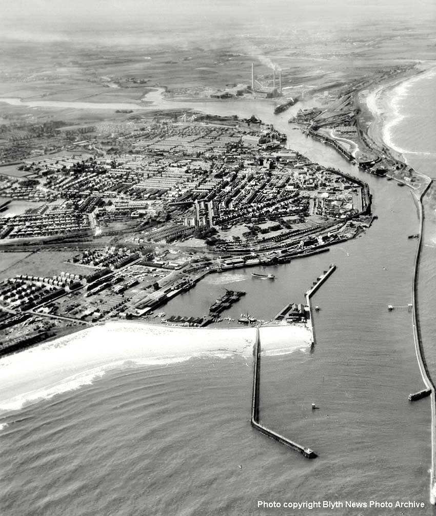
(Below) What a difference a few years make! This is a broader view of the harbour and town but it makes for an interesting comparison. We can see the whole of the South Harbour with its Fish Quay and West Quay in the lower left corner. The Middle Jetty has a large vessel moored up. Another vessel is reversing and turning away (suggested by its wake) from the North Quay. The bow looks quite high in the water so I expect it has offloaded its cargo. Just above the turning vessel we can see quite a number of railway wagons, however note how empty the South Staith looks. No vessels seem to be moored up there at all and there does not appear to be any railway traffic. That being the case, note how the power station has developed. The A station on the right is fully functioning and that was completed in 1960. The B station looks to be well on its way to completion but the West most chimney is yet to be built. So on the basis of that, and knowing that the B station was completed in 1967, the date must be about 1965. The South staith was last used in 1964, so that would explain why it is devoid of vessels and trains. The South staith was demolished in 1966-67. Since demolition has not started to take place, I am pretty sure that the date of the photo must be 1965-66. Crossing to the North staith, there is a vessel moored up, but I see no rail activity - and, given the date the North staith will have been out of use at that time too. However looking up to the West staith by the power station there is a plume of smoke from a boat. The West staith was the last to survive and remained in use for many years. Looking to the Cowpen Coal Co's staiths at North Blyth there appears to be quite a number of wagons on the C & C Branch and on the staith at spouts 1 & 2. Also of note are the new concrete structures at Bates Pit. Bates underwent some surface buildings and trackwork modernisation in 1960, so the new concrete suggests it is not many years after the colliery was upgraded.
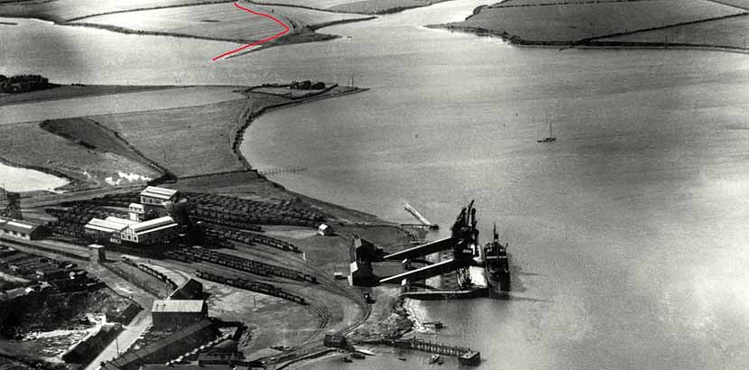
(Above) Whilst perusing old aerial images of Blyth, this one immediately grabbed my interest. It doesn't look much, but it does in fact have a very interesting history…here we have Bates Pit in the foreground and the newly built Bates Loaders circa 1933. Of course by this time the River Blyth had been altered beyond recognition in comparison to when the river was originally used to transport goods from Northumberland. The first thing that caught my attention is the spit of land (marked with red) that juts out from the north bank of the river at the confluence of the River Blyth (coming in from the left) and the Sleek Burn (coming in from the top). Since it doesn't appear to be a 'natural' feature of the river I wanted to know its significance and got quite a surprise! As a small boy playing in the fields on the south side of the river I saw this spit countless times, yet never thought to ask what it was for. Too busy playing! So now, after all these years, I want to share what I have learned…and what a journey it has been to find out!
We start by going back to the year 1818…just four miles to the west of this image is a little village called Nedderton (just to the west of Bedlington) situated on the modern B1331. Nedderton was originally called Netherton and in 1818 the Netherton Pit was sunk, using the River Blyth as a means to transport coal efficiently away from the area. A waggonway was constructed from the pit in a predominantly easterly direction to Barrington, where it then made its way to Bedlington Station as it is known today - but of course, this was long before the great railway building boom and the station. The waggonway continued eastward to the edge of the river - and amazingly, almost 200 years later, the route can still be traced with the use of aerial maps. The construction of the waggonway must have been considered very carefully as no major engineering structures (such as bridges, tunnels or embankments) were required along the route, however some of the inclines were moderately steep, so steep in fact that horses did not draw the wagons on the descent but rode behind them in a dandy, gravity doing the work for them!
In his notes dated 10 December 1847 Mr. T. E. Forster wrote - 'From the pit to where the coals are put on board of keels in the River Blyth, the distance is 4 miles. The first 1 1/2 miles the wagons run down and the horse rides in a dandy behind - 1 in 70 descent, the next mile ascends at 1 in 40 (belongs to Mr. Longridge), and the remainder falls 1 in 70 to the staith. A horse takes four wagons the whole distance and it requires six horses to lead about 20,000 chaldrons.'
It is noted that the first shipment of coal from Netherton Colliery via this particular waggonway was in 1819; the coals as mentioned being transferred to waiting keels on the River Blyth and thence to colliers waiting downstream in deeper water. With the opening of the Bedlington Colliery in 1837, Netherton had to remain competitive, so a brand new twin screw steamer of 'special' construction was ordered in 1842. The vessel was named 'BEDLINGTON', she could carry a total of 40 chaldron wagons (each of 53 cwt equating to approximatley 95 tons) which were put directly on board the vessel at the Netherton Staith on the river, and the 'Bedlington' then took the shipment down to the Tyne where the chaldrons were hoisted by on-board steam powered derricks and the coal tipped into a waiting collier. It sounds like quite a vessel! I wish I could find a photo of her…
The 'Bedlington' must have had a shallow draft as the river was not dredged so high up pre-1853, and I expect that the vessel could only access the Netherton Staith at high water. The 'Bedlington' did not stay on the river for many years though. In April of 1851 the vessel was sold as a ferry boat between Granton and Burntisland on the Firth of Forth! She was basically a roll on roll off ferry carrying coal and passengers across the mouth of the river. Bear in mind that the Forth Bridge was not built at that time, so trains used to go to Granton and offload passengers who would use the ferry to cross the Forth and join a train again on the other side.
Sadly, I do not know what name 'Bedlington' held whilst in service on the Firth of Forth. However her service there was short-lived as she was acquired during the Crimean War (October 1853 - Feb 1856) as a transport ship in the Baltic. She would have crossed the German Ocean as it was called then (today's North Sea) to access the Baltic via the Straits of Copenhagen or Denmark. Alas her service for the war effort was cut short because she was among 29 British vessels lost in a terrific storm in November of 1854, no doubt carrying essential supplies to the armed forces caught up in the dreadful freezing winter weather of that year. Thus far I have been unable to find anything else about her since she was lost, such as where she lies or whether she has been found and identified. I expect that the lack of information answers that question.
As I said at the outset quite a journey, all generated from a tiny spit of silted up land in the River Blyth showing up on an old photograph! I certainly didn't think I would find myself researching old ferries in Scotland let alone find myself crossing the North Sea and visiting the Baltic. The rest of my journey continues below...
PART ONE
POWER STATION, HUGHES BOLCKOW, NORTH BLYTH SHED,
BATES PIT, C&C STAITH and WEST STAITH.
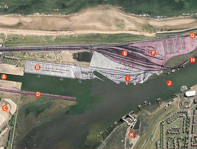
The first section of the LNER 1934 map (below) is superimposed over a 2006 Google map showing the changes that have taken place over the 60-odd years...the result is startling! Points of interest are marked in alphabetical order and are related to the photos included in Part One. They are: A = Ash Disposal Dock; B = Tidal basin Extension of 1934/5 adjacent to Boca Chica; C = Site of Power Station; D = West Staith; E = LNER full coal wagons sidings; F = North Blyth Engine Shed; G = Cowpen and Cambois Branch; H = North Staith; I = Hughes Bolckow breakers yard; J = High Ferry crossing point and K = Cowpen Coal Co. Bates Pit spouts.
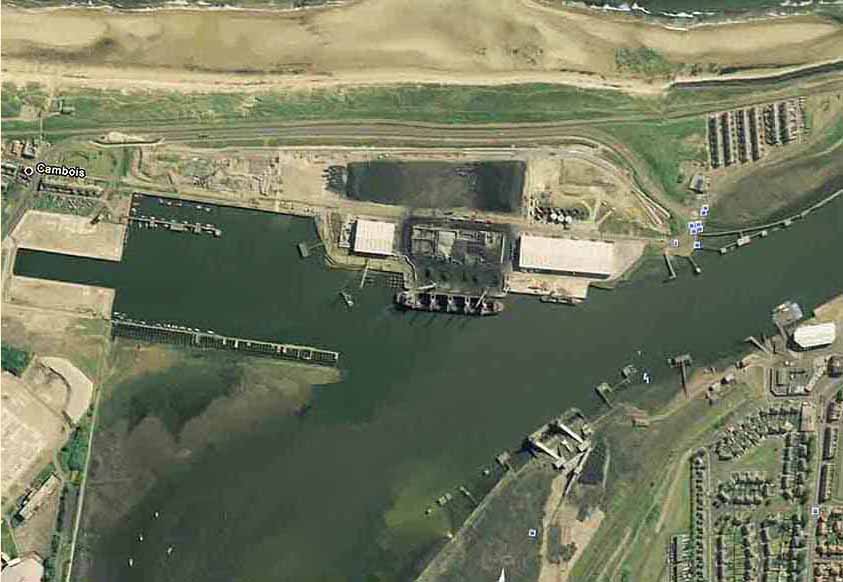
(Above) Having been brought up in Cowpen, I have always had a soft spot for Blyth, and had no desire to leave all my childhood friends behind when dad started his new job in Skipton. I was 12 years old at the time and the move hit me hard.
Thirty-odd years later, however, my interest in Blyth has never abated - rather it grows from strength to strength. At every opportunity I look out for subject matter on the Blyth & Tyne Railway, referred to as 'The Mouse That Roared' in a wonderful article by Terry Wright that appeared in the August 1999 edition of Steam Days magazine. As soon as I had a connection to the Internet at home my earliest searches were for Blyth, although very little came to light at first.
However, over the years a growing number of people with fond memories of the town have contributed more and more to the Internet, and so I'm pleased to add my own contribution based around the LNER map of 1934. It is a delicate document now - almost 76 years old - but the map is clear enough to show in detail the network of lines that once served the town.
Today, of course, nothing remains of a railway in Blyth itself, the last to go being the Bates Pit line (lifted in 2007) and the only track left in North Blyth is the branch line (marked 'G' on the map) that runs from West Sleekburn out to the Alcan Terminal.
Then there is the dock at Battleship Wharf (marked 'I' on the map) which is now used for importing coal - in fact, a vessel is being unloaded in the Google map and a huge stockpile of imported coal now covers an area once occupied by the North Sidings; it is an unbelievable turnaround for a town, which, at its height was the largest coal exporting port in Europe! Even crazier still, Blyth and Southeast Northumberland is sitting on a vast seam of coal, yet the coal that now travels by rail is imported from Poland. And if that isn't ironic enough, the imported coal is taken to feed the Yorkshire power stations, which also sit on top of a vast quantity of coal - the whole thing is just plain barmy!
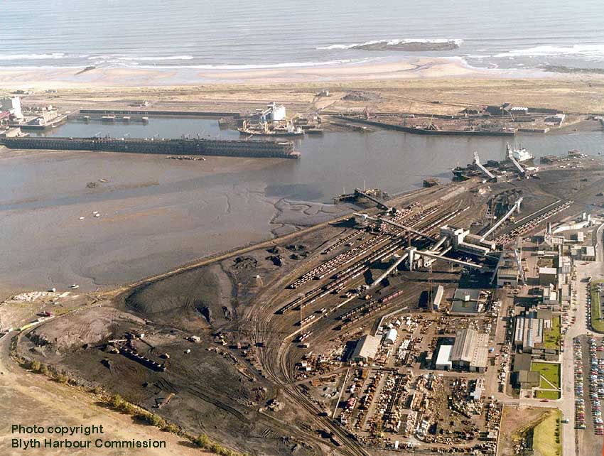
(Above) This aerial view of Bates Pit and associated sidings rekindles fond memories of growing up in the shadow of both the Power Station and the Bates Pit during the 1970s - the latter being a strict 'no go' area for me as a kid. In those days, discipline was strict and I did as I was told, and never went beyond the fence line, just visible in the lower left corner.
The large tripods in this view contain the conveyors for loading coal into the wagons and the black coloured arm that stretches out into the river is the spoil conveyor. A boat was loaded there and the spoil taken out to sea and dumped. The two large Bates loaders can also be seen on the river edge where a ship is being loaded.
On the opposite bank, the Hughes Bolckow site is empty and the north sidings are gone, therefore this image is dated 1982 or thereabouts, certainly before the miners' strike of 1984 and the ensuing demise of the coal mining industry. It is difficult to see the winding gear of the pit in this view, but it was one of the main features visible to me from my bedroom window.
Of course, I had no idea how extensive the Bates site then was. It is amazing to think that, like an iceberg, the surface was just the tip of it, that the shaft was sunk over 1000 feet deep and the workings extended 7 miles beneath the seabed. Judging from this aerial view, you'd be mistaken in thinking that it wasn't a very nice place to grow up, but behind the camera were numerous riverside fields to play in and the rural scenery across the river definitely outnumbered the industrial views.
However, I do remember the acres of sidings at Bates Pit and watching the navy blue NCB 0-6-0ST locomotives hauling wagons full of coal up the steep incline to Isabella exchange sidings where BR locomotives collected them. I also recall this stretch of branch line being used for the making of a railway safety film for children. The filming took place where Dene View Drive crosses the line, using a locomotive and a short rake of wagons. The scene involved children playing on the railway line and a boy getting hit by the train - the moral of the story being 'Keep off the railways'. I wonder if the footage still survives in an archive somewhere? It was a lecture we always got before the holidays.
Alas, it wasn't heavy industry that killed one of my young friends but a mishap at the swimming baths when he dived into the pool from the highest board and hit his head on the bottom of the pool. No one realised what had happened until it was to late. His name was Philip too, a close friend. He was only 8 years old.
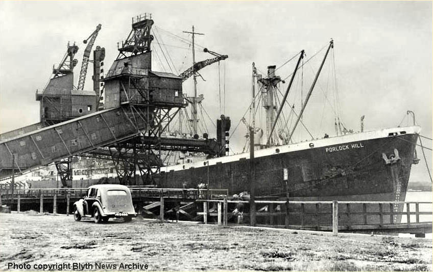
(Above) This is a shot of the 7,200 tonne cargo ship, Porlock Hill, being loaded with coal from Bates Pit. Originally named Samchess, this cargo vessel was a Liberty Ship launched in January 1944 and loaned to the British for the duration of the Second World War. For the uninitiated, more than 2,700 Liberty Ships were mass produced during World War 2 in response to a critical shortage of maritime cargo vessels. The ships carried wartime cargo and supplies, including food, fuel and ammunition across the Atlantic. By 1945, the fleet of Liberty Ships became the greatest standard fleet in world history and many vessels participated in combat with enemy forces. Therefore it's such a crying shame that the Merchant seamen who served aboard Liberty Ships became the forgotten sailors of World War 2, since those who participated returned home after the conflict and were denied benefits for injuries and often overlooked in victory celebrations. In recent years, however, maritime and naval historians have shed light on the significant contribution of the Liberty Ships and their sailors. Their contribution to the war effort was tremendous, for the fleet of ships carried two-thirds of all cargo leaving US ports in support of the Allies overseas. After the war, Samchess was sold privately to the Somerset SS Co and served under the British flag (Counties Ship Management Co, London) and renamed Porlock Hill, but four years later she sank off Famagusta and ended her days being scrapped in Italy.
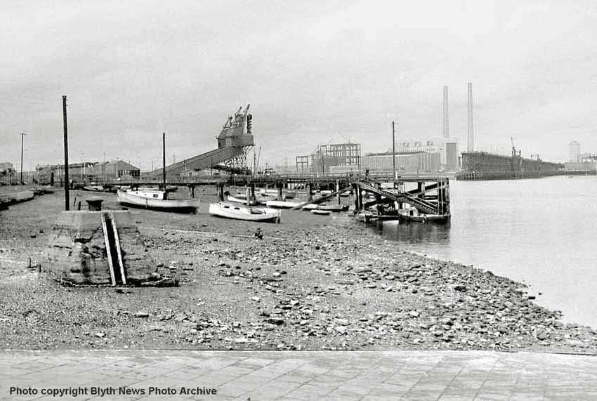
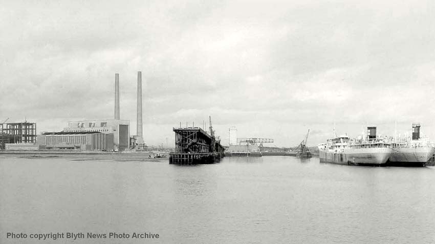
(Above-Below) Dating old photos can sometimes be a problem. In this photo the power station is incomplete. Blyth 'A' is finished and is functioning as there is steam venting from the turbine house, however just to the left, the construction of Blyth 'B' is taking place. Permission for building Blyth 'A' Power Station was granted in February 1955, and its construction took place between 1955 and 1960. The station's first unit went into operation in December 1958, and the 'A' Station was fully operational by June 1960. Therefore it is possible to date the picture after June 1960. However there is additional info that helps. The construction of the 'B' Station began on 4th December 1961. Its first unit was commissioned in December 1962 one year later, and the rest of the station was fully operational by September 1966. So the picture must have been taken early 1962 as building work has visibly progressed on the steel girder frame construction but it is far from complete. The picture was taken from the south side ramp of the High Ferry. The large grey concrete structure to the right of the west staithe is the ash disposal plant and silo.The odd-looking spouts in the middle distance on the left bank are those of Bates Pit, which are not part of the LNER property. The West Staith spouts are visible and are numbered 17-20, though no trains appear to be on the staith. (Below) This is the same scene at High Tide.
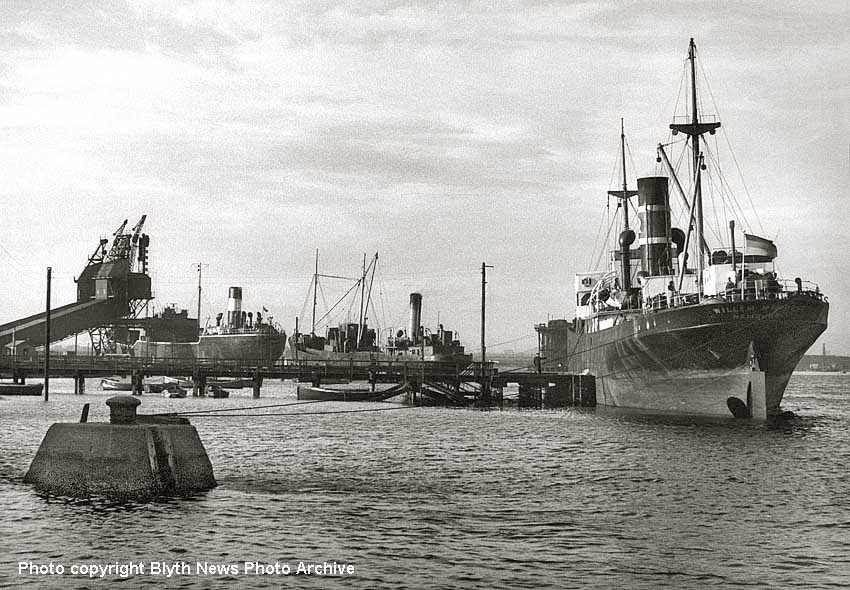
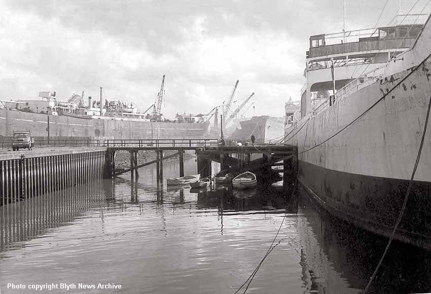
(Above-Below) This photo is looking straight into the ash disposal dock. The Pulverised Furnace Ash (PFA) and Furnace Bottom Ash (FBA) were by-products produced by the burning of coal in the station, these days we call it gypsum and it is used in the making of plasterboard. Bottom ash was removed from ash hoppers at the bottom of the boilers by high-pressure water jets. It then travelled to ash settling ponds via sluiceways. For much of its life, the station was served by a series of barges, which took the ash to dump out at sea. Two barges provided this service over the years: Sir Fon and MVA. The barges were loaded from silos situated at a special dock to the east of the stations. The image also shows the BP Tankers Jasmine and Jaguar awaiting disposal at Hughes Bolckow's on the right, and the vessel in the water beyond their bows is the BHC rock breaker, which appears in several photos taken in different parts of the port (mention is made of this vessel below). The east most ash silo is not built yet in this image. In fact the picture was taken on the 19 July 1960. (Below) This photo shows a close-up view of the disposal of BP Tankers, Jasmine, Jaguar, Austanger and Jean Baptiste. On the immediate right, Jaguar and Jasmine are berthed alongside each other and the vessel beyond with no top decks is the Austanger. The ship in the tidal dock on the left is Jean Baptiste (a Liberty Ship) built in 1943 as Fort La Tour and arrived in Hughes Bolckow's on 16th July 1960.
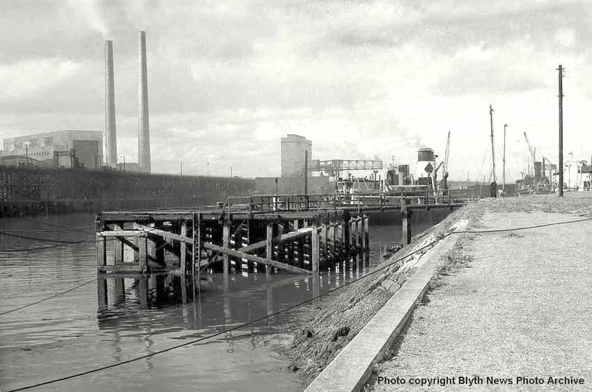
(Below) Another shot of the dock, this time viewed from the Cambois foreshore of the tidal basin constructed during 1934 (see LNER map). The dumping of ash in the North Sea was stopped when the International Convention for the Prevention of Pollution from Ships prevented further dumping at sea. From then on FBA (gypsum) was sold to the construction industry, while PFA was either dried for sale, or was disposed of at a licensed landfill on-site.
(Above) An interesting photo taken from the construction platform part way up the east chimney of the B station in 1965. In the distance, a Class J27 departs North Blyth Siding with coal empties and a vessel is being broken up at the Hughes Bolckow yard. The new-looking vessel berthed at Mooring Stage 25 is either being used for the shipment of scrap metal or transporting coal. It is quite unusual in that the bridge is forward-amidships and the single funnel at the stern. I did wonder if this was a Liberty Ship being put to good use in the post-war years, but Liberty Ships have the bridge and funnel in the amidships position, and this one is a different beast altogether. In the foreground, the West Staith is occupied by smaller vessels awaiting another shipment of exported coal. A few years ago, whilst on a rail enthusiasts' trip my dad and I had the privilege of sitting with two chaps, one called Neil and the other Peter, both of whom worked for BR in various capacities, including accident investigation and safety. During the trip we learned many new things from a BR perspective. Both men visited Cambois on numerous occasions, and no matter how many times they walked on the West Staith they could never get used to the movement and sway of the whole structure as a fully loaded train crept out to the coal drops. I had to laugh as they commented on the east wind. I know from my own experience that Blyth is no place to be when an east wind blows during the winter, especially when it finds its way up your trouser leg...a lazy wind that could shatter bones! How the men managed out on the staithes through the winters doesn't bear thinking about.
(Right) This elevated shots shows construction of the ash dock from the top of the east most chimney of Blyth 'A' station. The dock is in the process of being 'piled' with reinforcing steel work that will become the concrete dockside. The rectangular form of the dock can be seen between the chimney lip and the davit winch wheel. As mentioned earlier, the BHC's rock breaker is featured in several photos on this page,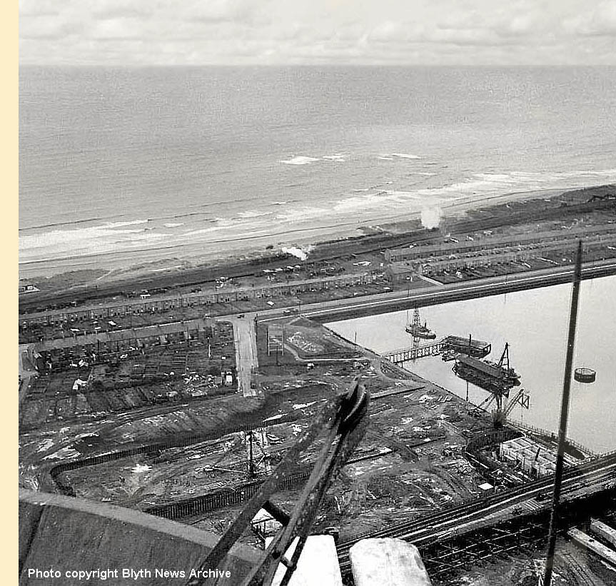 including this one - click on image to enlarge. I am grateful to David Fraser for the following information on this interesting vessel.
He writes - 'The Harbour Commissioners floating plant is a Lobnitz rock breaker or rock cutter as they were often referred to, one of a pair costing more than £6000 each, ordered in April 1906 from Messrs Lobnitz & Co of Renfrew in Scotland and both delivered to the Blyth harbour during 1907.
The Blyth harbour has always had a rock base and to increase the harbour depth, these two rock breakers were purchased. They comprised of a mild steel barge 100 feet by 28 feet, with a steam boiler onboard working at 100lbs pressure, a cutter hoisting winch, a donkey pumping engine and both had a manoeuvring winch to aid accurate positioning. A wooden roof covers the whole barge and a very tall chimney stack protrudes. The shearlegs support a large cutter weighing up to 20tons and some 50ft long with a conical point which when dropped onto the river bed, broke the rock over a wide area so that a bucket dredger such as the 'Cowpen' could subsequently remove it.
When this pair were ordered, both rock breakers had the shearlegs design situated in the barge centre, but it was quickly realised that they could not work right up against either the harbour jetties or the wooden coal staiths. The ordering specification was amended prior to construction and one barge was supplied with the shearlegs mounted on the end and could then work right against any of the harbour structures while the other barge retained the centre mounted shearlegs.'
(Below) I have often wondered how the name 'Boca Chica' in Cambois (seen on a section of the old LNER plan) came to receive its bizarre name, and discovered the answer in an old book - ''The History of Blyth from the Norman Conquest to the Present Day' (2nd edition of 1869) by John Wallace. The author tells a wonderful story about two seamen who saw naval action at the Battle of Cartagena de Indias (Columbia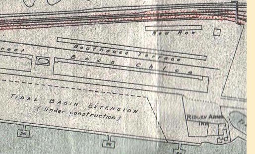 today) in South America in March of 1741. Having survived the battle the men made it home and of course told the tale of their exploits (no doubt with many flourishes and embellishments) and their frequent mention of the name Boca Chica led to one of their companions jokingly naming where they lived Boca Chica. It was immediately adopted by the locals and continued in use right up to the demolition of the colliery rows. Here is the exact wording from his book - '1745. About this time 'Boca Chica' received its outlandish name. Two seamen belonging to the place laid Bended on board a ship-of-war, under Admiral Vernon, at the siege of Carthagena, a seaport in South America, in 1741. The entrance into the harbour was termed Boca Chica (little mouth), and was defended by several forts, the whole of which were taken by the British forces. Those seamen having returned home in recounting their exploits at the siege so frequently used the words Boca Chica, that one of their companions jocularly gave the name to the place of their residence; the new name took with the public, who at once adopted it, and to this day Boca Chica has continued to be the name of the northern portion of the High Pans.'
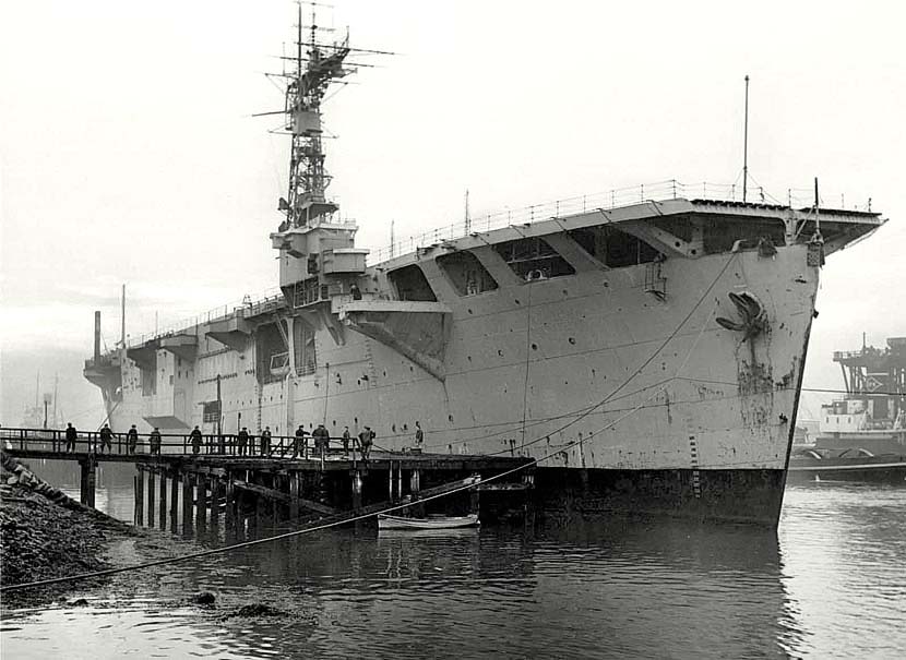
(Above) HMS Campania (D48) was built as an Escort aircraft carrier weighing in at 16,042 tons gross. She was built by Harland & Wolff Ltd (Belfast, Northern Ireland) first laid down 5th August 1941, launched 17th June 1943 and commissioned 7th Mar 1944. She saw service in the North Atlantic, Norway and the Arctic. At the end of WW2 in 1945 she was laid up in the Naval Reserve at Rosyth. Despite early retirement, the 1951 Festival of Britain gave her the opportunity to ply the waves again. She was reactivated as part of a mobile exhibition, painted white and festooned with bunting and flags. Manned by civilians she visited Southampton, Dundee, Newcastle, Hull, Plymouth, Bristol, Cardiff, Belfast, Birkenhead and Glasgow, staying at each port for 10-14 days between 4 May and 6 October 1951. After taking part in the festival, she saw further use becoming part of the task force for Operation Hurricane, an exercise for the testing of British atomic weapons at Monte Bello Islands archipelago eighty miles north west of Australia in October 1952. Her respite was brief though and her service days ended in December of 1952. She was sold for scrap in October 1955 and by November 1955 she was at Hughes Bolckow, Blyth for cutting up, as seen in this sad view of her. Only 11 years old! What a waste! The very end of the West Staith can be seen in the far right of the image. Click for a resume of her wartime activity.
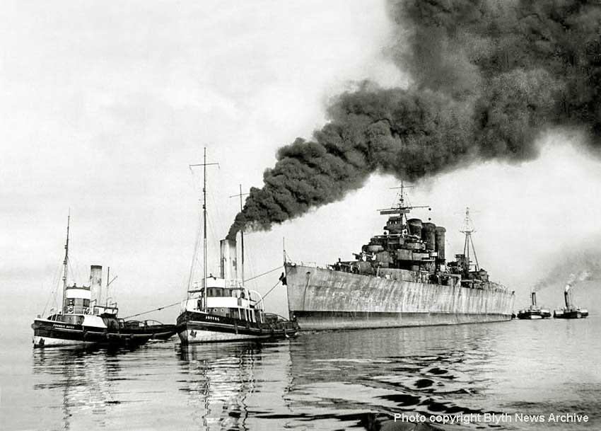
(Below) Final voyage of HMS Berwick being towed to the breakers yard at Battleship Wharf, Blyth, on 12th July 1948. The Kent Class cruiser HMS Berwick was the first of her class. Launched on 30th March 1926 she was commissioned for trials on 15th July the following year. Click here to visit the excellent 'Naval History' website. HMS Berwick had a long association with the civil community of Berwick on Tweed before the ship was placed on the Disposal List in 1948. This photo shows her entering Blyth Harbour in tow to the breakers yard.
For the record, Hughes Bolckow Limited was established as a partnership between Ralph Townsend Hughes and Charles Frederick Henry Bolckow in August 1906. Initially, the pair started business in the existing Wharfage owned by Hughes at Derwenthaugh on the Tyne river. The yard was situated upstream above the Newcastle bridges, which presented clearance problems when bringing ships in for scrapping. The first scrapping was a Norwegian cargo ship, the 'Norfolk', which ran aground on the Black Middens at the mouth of the Tyne in January 1908. The first warship to be scrapped, 'HMS Collingwood', was dismantled to lower her draft sufficiently to tow her alongside at Derwenthaugh.
The next warship, 'HMS Barfleur' was an old battleship of 10,500 tons, and on arrival in the Tyne in 1910 she became wedged between the sides of the Tyne swing bridge and refused to budge. In view of the the restricted access, Hughes approached the Tyne Improvement Commission for a deeper water site further downstream, but the application was rejected.
In November 1911, Hughes signed two 50-year leases for a new shipbreaking site in deeper water at Cambois, on the North side of the River Blyth. One lease was with the Blyth Harbour Commissioners for the dredged site and wharfs, the other with Lord Ridley for plant acreage and rail connections. Click here to visit the excellent 'Shipnostagia' website, an online community for anyone with an interest in ships and shipping. The information in this caption is attributed wholly to Ron Rooney, whose expert comments on the origins of Hughes Bolckow is unquestionable.
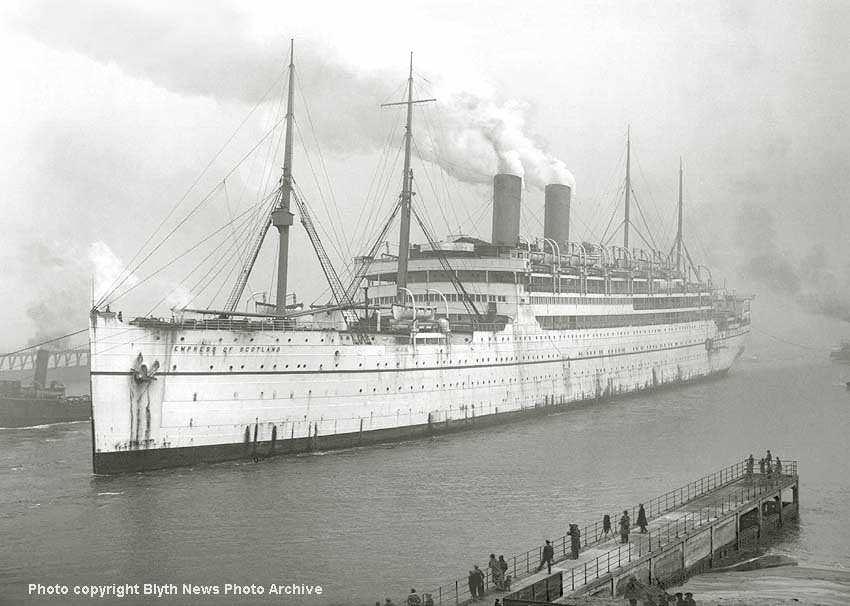
(Above and Inset) The 'Empress of Scotland' makes a stately entrance to Blyth Harbour on her final journey to the breakers yard at Hughes Bolckow in December 1930. The Empress of Scotland (formerly SS Kaiserin Auguste Victoria) was built by Stettiner Vulcan AG in Stettin in 1905-1906. The ship left Hamburg on her maiden voyage to Dover, Cherbourg and New York in May 1906. Thereafter she regularly sailed the route between Hamburg and New York. Following World War 1, the vessel was surrendered to Britain and chartered by the U.S. Shipping Board for the repatriation of American troops from Europe to America. The ship made five crossings between France and the United States.
In May 1921, the vessel was sold to Canadian Pacific, re-named the Empress of Scotland and embarked on her first voyage from Southampton to New York in January 1922. Eight years later, the newly-built Empress of Britain was introduced on the lucrative Trans-Atlantic crossing and the Empress of Scotland was sold for scrap to Hughes Bolckow at Blyth.
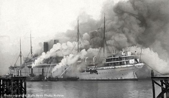
After arrival at Battleship Wharf, the ship's interior fixtures and fittings (a valuable source of income for the salvage yard) were auctioned off during public viewing days, but on the final day a catastrophic fire broke out in her stern. As the fire got hold, the billowing smoke mercifully blew offshore; though I doubt if the residents of Cambois and North Blyth thought it a very nice place to be with all that acrid smoke around. Even battening down the rattling sash windows wouldn't have done much good.
I'm mindful of the sash windows that we had in our house! I could never work out if the bedroom windows rattled more than our teeth on cold windy nights; just thinking about it still gives me the shivers today - itchy scratchy blankets and candlewick bedspreads!
As for the outcome of the fire? The photo (below) shows the ship ablaze; the scene is one of bedlam and the jets of water from the hoses look woefully inadequate to tackle the blaze. Note one of the Blyth paddle tugs in attendance. The Harbour Commissioner's fire float was soon at the scene, but with 20-foot high flames sweeping through the vessel and the tremendous heat causing so much damage, it was decided to scuttle her where she lay.
On December 15th the demolition team eventually made a start on the twisted and burned-out hulk sitting on the riverbed. Her two funnels and part of the superstructure were cut down, and by the end of February the ship was refloated and pumped dry to allow for further demolition. In May, it was planned to tow the Empress to the Tidal Dock for final cutting up, but the weakened structure collapsed while under tow and broke in two, and it took until October 1931 before the last remains of this once-proud ship was finally cut up. Click here to visit the excellent 'Great Ocean Liners' website, which contains details of the ship's history and its luxury interior.
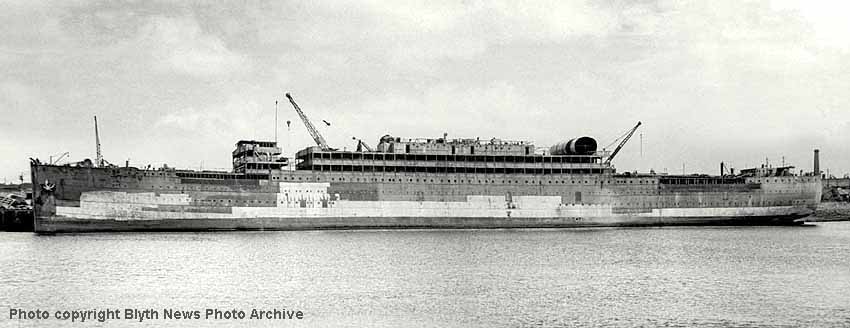
(Below) I originally identified this photo as the Empress of Scotland being broken up, but since posting the image on the page I've received an email from an A D Frost who says this is not the case. He points out that the sterns are very different and the vessel is in fact the SS Westernland. Well, after a bit of digging around he is most certainly correct. The Westernland began life in Germany. She was laid down before the outbreak of WW1 and named Regina, but war delayed the work. She was eventually completed as a cargo ship in 1918 after the war then to a passenger ship in 1922. It seems that she got her new name Westernland in 1929 when she went into service with the Red Star Line. In 1935 she was sold to the Arnold Bernstein Line but retained her Red Star Line livery. Bernstein's Red Star Line ceased operating when he was arrested by the Nazis in 1937. During WW2 she was used as a troop ship. I have no idea how she came to be broken up at Bolckows Blyth in 1947…perhaps she was a captured vessel and used by the Allies or she was bought from Germany for scrap after the war? The facts are, though, that she was brought to the River Blyth in 1947 and broken up that year. Comparisons with other pictures of the Westernland confirm that this is indeed the same ship. My thanks to the eagle-eyed Mister Frost for the correction...
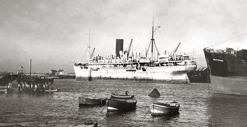
(Above) During WW2 HM Hospital Ship Vasna plied the waves doing her bit for the war effort. After many years of service she arrived in Blyth in April 1951 and is seen here awaiting her fate with the cutters torch at the Bolckows Wharf. Built in 1917 at Alex, Stephenson & Son Glasgow, the vessel was requisitioned during construction by the Government and completed as a hospital ship; the last of a small fleet of four V Class vessels - click here to visit the 'Roll of Honour.com' for details of her wartime history. In this image the weather for Blyth is very fair, though the stern flag in the left hand side of the picture appears to be blowing in a stiff Westerly breeze. Given the shortness of the shadows it must be the middle of the day or soon after as the sun is shining on the west facing side of the ship. Given the water mark on the mooring stage the tide is not at its full height either. When this photo was taken, construction of the power station had not begun, so the upper part of the harbour then had an 'open' feel about.
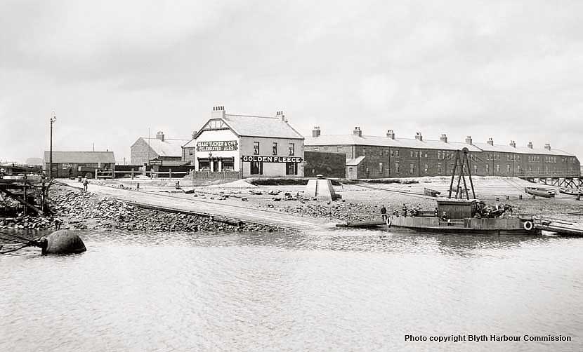
(Above) Dating old photographs can be an interesting though sometimes difficult process. All manner of clues can help with dating a photo; such as clothing fashions, advertising hoardings, and type of vehicles - plus the buildings themselves, of course. Knowing when a building was built or demolished, or owned by a certain company all count in the process. It has surprised me numerous times that in verifying the date of a photo, all too often the source of the research material I am examining has been dated incorrectly.
 A case in point is this photo (above) of the Golden Fleece (taken from the original negative) at the High Ferry crossing point in Blyth. I'll take you through the process I went through in deciding the approximate year the photo was taken, though this has not been an easy task since the photo has been dated incorrectly in a recent book.
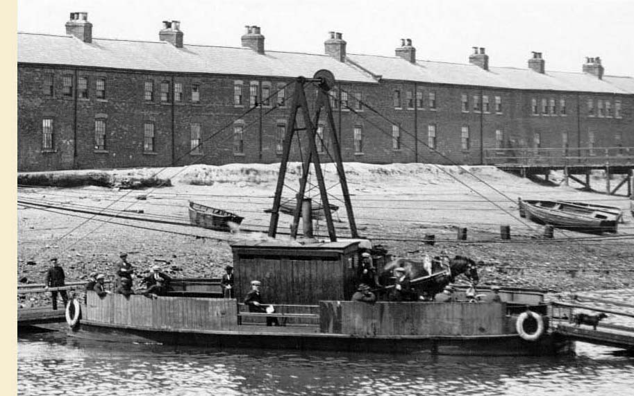
While studying the above image, the first three things that grabbed my attention were the pub, Cowpen Square and the ferry. Not much to report there you might think - or is there? Looking closely at the ferry (right) we can ascertain that the ferry is loaded and ready to depart for the north side of the river. How? Look at the horse on the ferry (with nosebag)…it is facing the opposite bank of the river (off to the right) and there are a number of individuals on the ferry too, therefore we can safely assume that the ferry is about to leave.
Heading back up the ferry ramp, it appears that there is little else to go on. Indeed one of the things that kept throwing me is that the photo is dated circa 1900 in the book I mentioned earlier, but since starting my research I can prove that to be incorrect. (Below) This is the errant image…I just love 'spot the difference'.
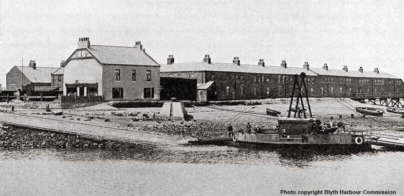
Having looked very carefully at this image I was able to see that it is the exact same image as the one above it! Notice the location of the ferry and its horse. They are in exactly the same position. Notice the cable masts on the ferry; they lie in the space between the fifth and sixth chimneys (counting from the Golden Fleece) on the roof top of Cowpen Square. Look at the three foy boats on the shore behind the ferry; they are the same boats and are in exactly the same positions. The angle of the photo is the same, though the picture content is slightly different to the original; this is because the left side of the full image is missing, however various things including the shadows prove that both images are in fact one and the same. Still something doesn't quite fit…where is the pub name? And why is the image cropped? Well, I shall come back to those two points later.
What a joy modern technology is. With the aid of computer software I have been able to zoom in on the image and what a revelation it is! It reveals vital clues that you cannot see with the naked eye on the original, all of which helps resolve the dating issue.
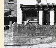 (Right) We can now see what is going on in this scene. A new brick wall is being built on the riverside at the pub. We can see the brickie is hard at work in his flat cap. It is a delight to be able to see the full name proudly displayed on the pub. In those days, Isaac Tucker & Co had a brewery in Newcastle, and had about 50 tied houses. Tucker's Turk's Head Brewery was established in 1790 and it is said that in 1891 it was the very first brewery to introduce pale ale into the area. However, as is often the case over the years many companies were taken over - and Isaac Tucker was absorbed by Whitbread Brewery in 1967 and three years later the Turk's Head Brewery was demolished by the Highways Department, no doubt to make way for one of the many new roads and the Newcastle Inner-City Motorway which were all built at about that time.
One of the other things that we can see in the photo is the Golden Fleece Quoit Ground sign (left) above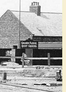 the barrow man's head. This brings back many fond memories of being a young lad watching the old retired miners playing quiots at a social club in Cowpen; hearing the shrill ring of the heavy metal quoits as they struck each other or the target pin set in the clay. Sadly the club has gone and the site is now occupied by a MacDonalds.
Another thing that brought a smile to my face is the 'barrier' around the work area, which is hardly a defense against errant pedestrians or a desperate individual trying to get into the pub for a 'quickie'. Also there is the chap walking his dogs, which can be seen beneath the Hudsons sign on the tin shack. Now, this is where I come to my point about the date of this image...
The key element to the date is the lorry! Yes, can you see it now and the two men leaning 'Last of the Summer Wine' style in their flat caps against the barrier? Nothing quite like watching hard work is there! There is no way on this earth that this picture can be dated circa 1900. The lorry is far too 'advanced' for 1900. Every effort has been made to get a 'close-up' of the lorry without losing clarity but it is impossible. Still, we can see that the cab is a substantial wooden or sheet metal enclosed structure. The wheels of the lorry appear to be of a 'solid' construction and not of a 'cartwheel' type with spokes. Alas, it is not possible to see if the wheels have solid rubber tyres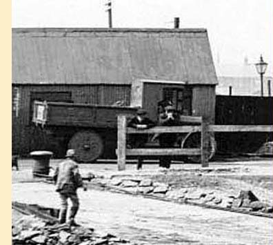 or pneumatic tyres, which would provide another clue to the date. However, by focusing on the cab of the lorry, that on its own tells me that the picture was taken after WW1 ended in 1918. At the time, the cabs of lorries were nothing more than glorified umbrellas made of a wooden or metal frame with a canvas tarpaulin attached, and since they had no windscreens, drivers of the time wore long heavy wax coats, leather gauntlets and big caps to protect themselves against the weather.
Moving into the 1920s, vehicle technology improved and of course cab designs improved too, and by the mid 20s enclosed cabs were the norm. That said, though, the era of this simple cab design was in fact very brief, as more streamlined cabs came into use very quickly when vehicle building technology improved. So, the window of time for this photo is now very narrow indeed, and this enables me to date this image at between 1925 and certainly no later than 1928. Interestingly, Thorneycroft built a lorry in 1927 which was very similar to the one in the photo.
One further element of proof is that CE Baldwin, General Manager and Secretary to the Blyth Harbour Commission, used the same image in his book 'The History & Development of the Port of Blyth' published by Reid & Co of Newcastle in 1929. However, the photo used in his book has had the pub name obscured -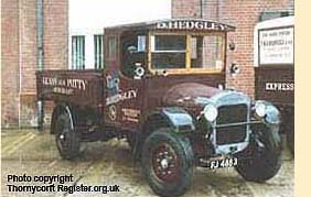 yes, I promised I would come back to that! Of course, featuring the pub name would have been construed as advertising, hence the name has been deliberately obscured from the photo. As for the image being a cropped version of the original? Well, it is most likely that it was done to fit within the page size - the photo in the 1929 book is reproduced in a 'landscape' format on a whole page rather than 'portrait'.
One thing that came to light whilst researching Blyth is the confusing and conflicting information in the public domain regarding the High Ferry. Research has revealed that the High Ferry crossing point received its very first vehicular ferry as we see (below) in 1890. That is a fact. The ferry was also renowned for being quite unstable and bobbing about like a cork high in the water. I understood from other research that the ferry was replaced in 1924 with the more familiar 'box'-type ferry. However, I can prove that information to be incorrect as this image with the '1924' ferry actually appeared in a Blyth Harbour Commission booklet of 1907! - I had expected to find some overlap in the service of the two ferry types, but not upwards of 14 years or more…so back to the drawing board on my research regarding the High Ferry.

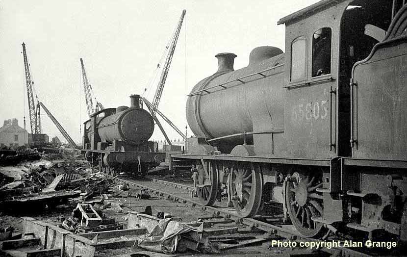
(Above) To observe these fine and industrious Class J27 and Class Q6 locomotives in such a lamentable state is a very sad sight indeed. This scene of Bolckows yard at North Blyth is reminiscent of a scene from the 'War of the Worlds' movie, with the towering cranes straddling the horizon like giant sentinels preventing these fine old engines escaping their fate - and the scene looks eerily quiet too…no doubt as workmen have taken respite from their destructive activity with a few beers in the Ridley Arms pub seen in the left background. The Class J27s and Q6s moved millions of tons of coal along the Blyth & Tyne Railway to the various power stations and staiths in the North East area, but only a solitary member of each class was reprieved from the cutters' tool. Click here for more information about the Class J27 and Q6 on the excellent LNER Encyclopedia site.
For over 70-odd years, the Hughes Bolckow yard handled ships of all types: Warships, Submarines, Passenger Liners, Tankers, Cargo ships, Trawlers, Tugs, various crane and support ships - even steam locomotives. For those interested to learn more about the locomotives cut up at Hughes Bolckow, the excellent RailUK website has a list... click here for link... there are 19 classes of locomotive and 72 recorded disposals, including three Class A4s: No 60034 Lord Farringdon, No 60024 Kingfisher and No 60026 Miles Beever. I'm all for recycling, but it's sad to think that such beautiful and magnificent machines could end up as razor blades.
This reminds me of old Barber Brock's on Seaforth Street. The whole town of Blyth knew him. Dad took me there for my hair cutting, but I hated dad's stipulatory 'short, back 'n' sides'! The kids at school used to call me skinhead, and I couldn't wait for my hair to grow again...when it did, it was back to Barber Brock's for another basinful! I remember dad always went first, sitting there in the big red barber's chair while I had to wait my turn; it only served to prolong my agony. Then, after dad had been done, a wooden plank was placed across the arms of the chair and I climbed up to sit at a proper 'working' height. I remember the lofty perspective I had of the shop: the glossed white tongue-grooved boarding around the walls, and the packets of plastic combs, shaving brushes, Wilkinson's Safety Razors and spare blades for sale. Above all else, I recall when it came to leaving how Mr Brock never failed to ask dad - 'Anything for the weekend, Sir?' - to which he replied, 'No.' (at least he did whilst I was with him). The shop smelled of Lifebuoy carbolic soap too. Sadly you cannot smell it on the Internet otherwise I'd provide a link.
(Right) I bought this old 'Time and Motion' study from a dealer on eBay, who found it in the loft after languishing there for 45 years! The chart records the walking distances to various points on the staiths and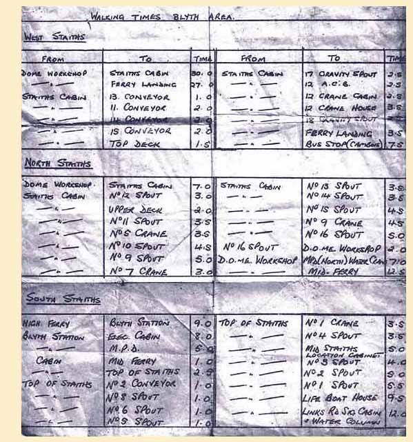 around the port.
I sent a copy to Fred Wagstaff, who replied - 'The walking times list was agreed between the Union and Management between different points on the staiths, but the study always seemed to be set during the summer months when the sun was shining and the birds were singing - never during inclement weather, such as icy fog, freezing snow and other conditions that made your balls shrink and your nose turn blue!
The 'Dome' on the list refers to the Department of Mechanics-Electrics, where the men were expected to keep all the loading gear and lighting on the staiths and Yards in good working order, and they generally did a grand job, but the Management seemed wary of time-served men, hence the list of walking allowances was devised.
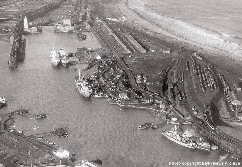
(Below) In this aerial view of the West Basin, the white building in the bottom left hand corner is the now-demolished Sidney Arms pub, named after one of four wealthy families in the area. To the left of the pub is the headshunt, which is part of the run round loop for the Bates loaders. The track occupies the land where Cowpen Square once stood. Just above the pub are the two mooring stages numbered 18 and 20, and moving up to the north shore of the river we see the West Staith with two ships moored at spouts 17 and 19.
Above them is the ash disposal silo on the left hand side of the new extension to the main tidal basin dock; this is fully operational whilst the second ash disposal silo to the right of it is incomplete, and therefore dates the photo to 1965-66.
The north sidings are clearly visible and lead onto the North Staiths where two ships are moored at stages 26-27. At their bows can be seen the ferry about to arrive at the north side ramp, above which is the Hughes Bolckow's breakers yard with a ship moored alongside. To the right of the ship's bow is the tidal dock and the white building at its head is called the Ridley Arms, named after another wealthy family in the area.
Perhaps at this juncture mention should be made of the Delaval, Hasting, Ridley and Sidney families. I recall my Bebside Middle School blazer badge (see inset left) which features the four family names on it. In the top left corner is the empty sleeve of the Hastings family, whose motto is 'Hold Fast To Justice'. Top right are the three birds and spots of the Ridley family and their motto 'Always Faithful' - the Ridley family home is Blagdon Hall near Stannington. Bottom left is Delaval. Hubert de la Val came to England with William the Conqueror in 1066 and was given land in the area, his motto being 'God Guide Me'. Bottom right is the blue Pheon (barbed arrow of a crossbow) of the Sidney family, their motto 'Wither the Fates call' and in the centre are the red and yellow stripes of Northumberland.
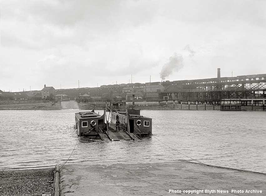
(Above) This picture shows the High Ferry crossing the river between the Golden Fleece pub (formerly Sidney Arms) on the Cowpen Square side of the river to North Blyth. In the background, a Class J77 0-6-0T is hauling wagons off the North Staith into North Blyth sidings.
(Right) Of great interest though is the semaphore signal beyond the ferry ramp on the opposite bank. I'm not sure of its purpose, but several options spring to mind. One is that it was used to summon the ferry from the south side of the river, second is that it controlled road vehicles down the ramp onto the ferry when it was safe to do so, however no such signal is evident in the vicinity of the south side ramp, which perhaps rules this option out. The third option is that the signal was used to warn the ferry operator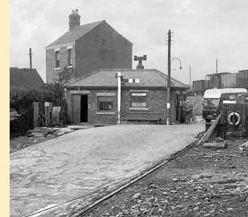 of river traffic. The ferry boat hauls itself across the river by chains, and these have to be lowered to the bottom of the river so that ships can pass without getting fouled up in the chains. However, the most likely option is that the signal protects the single-track rail link from BR, which gave access to Hughes Bolckow's salvage yard over a level crossing on the road between the shipbreaking yard and North Sidings (see map below). Evidence of a similar railway-style semaphore signal being used to control road traffic was located at Shrub Hill Crossing, Worcester.
Footnote: The Internet is a wonderful educational tool, full of interesting minutiae, yet I could find no mention of the mystery semaphore on the High Ferry landing and therefore my research drew a blank.
I was about to issue an appeal on this page when I was contacted by none other than Fred Wagstaff, who writes - 'The signal on the landing was to indicate that the Ferry had lowered the wires to the bottom of the river to enable ships to navigate up to the West Basin for loading or turning. The procedure was that a ship requiring to pass the landing would blow one long and two short blasts when passing Colpits landing to indicate to the ferry crew that they should drop the wires to allow the ship safe passage. If the Ferry was at the South side, he would immediately set off for the North side, because that was where the Cable tensioning gear was situated, and lower the wires. When the wires were safely on the bottom, the Ferrymen would give an answering long and two short on the Whistle, and pull the signal to the off position - why, I'm not sure because it would certainly not be seen in fog, or by ships coming from the West Basin direction! Of course, the people involved would all know what was planned to happen, and would be well briefed by VHF Radio if any alterations were to crop up. I remember an occasion when a 'new' J77 arrived at the Shed, fitted with an A4 calliope whistle. On its first week on the Staiths, every time the whistle was sounded, the Ferry crew went to panic stations, thinking a ship was en route...all because no one had told them!'
My thanks to Fred for solving the mystery in his own inimitable style!
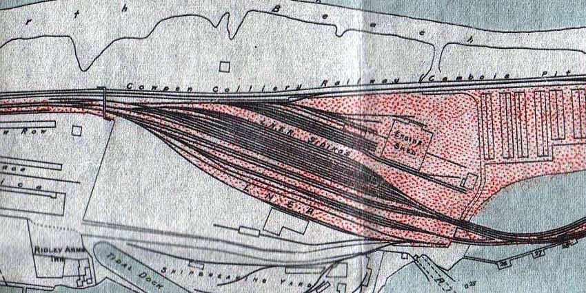
(Above) In this enlarged section of the 1934 LNER map of North Blyth Sidings it immediately becomes apparent just how extensive they were. At the top of the map - running along the shoreline - can be seen the Cowpen Colliery (C&C) Railway which, by virtue of the topography, was built on sand. Needless to say there were times when the track acquired a route of its own and this doubtless made for a hairy ride for the engine crew, particularly in wintery conditions when inclement weather raged in from the sea. The North Blyth engine shed (52F) doesn't look much, but in fact the shed building contained a 50ft turntable that served 12 stalls for stabling locomotives. The footbridge at the throat of the sidings was a popular vantage point for photographers. From there you could see the different elevation between the sidings of loaded wagons and the empty lines. The track fanning out into the sidings dwarfed the engine shed at a lower level, which was served by a single line descending to the shed yard and associated sidings, whilst the Hughes Bolckow salvage yard had a rail link.
(Below) Let me be quite honest about this, when it comes to giving anecdotal or factual information about North Blyth Shed and Sidings, no one can do it better than Fred Wagstaff, whose pages of reminiscences of footplate days at North Blyth steam shed and Cabois diesel Depot are superb. Quite simply, it was through reading Fred's pages that inspired me to do a page of my own - Fred also made available the majority of photos - and for that I am truly grateful. Click on Photo links below to visit Fireman Fred's pages…highly recommended!
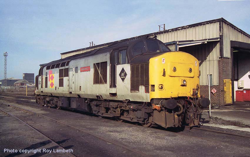
(Above) Amazingly the sun is shining for Rail Cameraman, Roy Lambeth, when he took this shot of Class 37 37403 Glenfalloch taking a break at Cambois Depot. The livery worn by this loco was introduced in the late 1980s, the red square and diamonds design being representative of Railfreight Distribution. British Rail separated its Railfreight liveries into six 'sectors' each with a different symbol. The sectors were: Coal, Construction, Metals, Petroleum, Railfreight General and Railfreight Distribution. The diamond under the nearest cab window (featuring the West Highland Terrier) is a BR Depot plaque, which tells us that 37 403 was based at Eastfield (ED) Traction Maintenance Depot (TMD) in Glasgow - shed code 65A for the oldies who can remember! The locomotive depot is now gone and a new maintenance of Diesel Multiple Units has been built on the site.
(Below) Class 56 066 in Coal Sector livery at Cambois is looking rather unwell with roof panels removed from the No 2 end for access into the electrical control cubicle and alternator compartment. Most of this class were withdrawn from service by EWS on 31 March 2004, but a few remained in service with Hanson Traction Ltd. Five are now in preservation. Makes me feel old as I remember the class being introduced in 1976. Sadly, unlike other classes of loco like the Class 37 in the photo above, which saw upwards of 40 years of service, the Class 56 fleet served less than 30 years at best. No's 56 001-56 030 didn't serve very long at all; these Romanian-built locos were of poor quality and removed from service relatively early. A link is provided here to Fred Wagstaff's memories of Cambois Diesel Depot, and a link to Roy Lambeth's first 'Rail Cameraman' page is here.
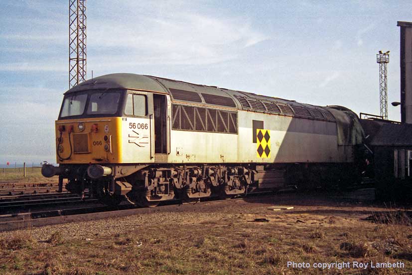
(Above) As mentioned at the top of the page, some readers may find a few inaccuracies along the way, therefore I do invite anyone who wishes to discuss the contents to contact me (my email address is at the bottom of the page). Feedback is so important, particularly if it helps correct any inadvertent mistakes therefore I am grateful to Tony Falloon, who recently contacted me regarding the photo of 56066…
Tony writes - 'Hello Phillip, with reference the web page you have within David Hey's collection, I wish to bring to your attention an error you have regarding the photo of 56066 where you say the roof panels have been removed above number 2 cab.
In fact the damaged cab had been removed altogether to allow the loco to be hauled to Doncaster Works for a new cab to be fitted. The loco 56066 was involved in a collision South of Morpeth on Friday 13th November at 23.20hrs. Sadly the driver of 56066 received fatal injuries, and his train - a loaded coal train ran into the back of an empty pipe train just north of Clifton Crossing, Morpeth.
I was a Maintenance Supervisor at Cambois at the time and was called out to the incident and subsequently attended the Coroner's inquest at Bedlington. Kindest regards, Tony Falloon.'
In response to Tony's letter, I did a bit of digging around on the Internet to find out what took place on that fateful Friday 13th Nov 1992, and found the following information on Wikipedia - 'The accident occurred during engineering work and was the result of the locomotive driver and the signaller at Morpeth failing to come to a clear understanding concerning required movements...'
Well…once again Tony Falloon has contacted me and much of the info on the Internet about the crash is INCORRECT! I'll be blowed (Wrongipedia again) though it comes as no real surprise - no disrespect to Wikipedia intended, but it is important to get the facts right. Tony was part and parcel of the inquiry, so it is from the horse's mouth so to speak and his additional information must be included on the page to set the record straight. This is what Tony had to add...
'There is quite a lot of Internet-based information on the train crash at Clifton and all of it - well, the bits I have read anyway - are far from what actually happened. It did not occur during engineering works and it was not a light engine etc. There were two trains involved 6E67 and 6E76 - the rear one being a loaded coal train destined for Yorkshire headed by 56 066, and the front train an empty pipe bolsters destined for Teesside headed by a class 37. The trains would normally run 6 hours apart but because of signalling problems in Scotland they were running together, separated of course by the signalling system. The Morpeth Signaller was having problems with the automatic crossing at Clifton, where he could not get detection of the 'barrier closed circuit' which meant he could not set the signal protecting the crossing to green; he could see the crossing was clear of road traffic and the barriers were closed by his CCTV. The first train stopped at this signal and the procedure is for the driver to contact the signaller via the signal post telephone, where the signaller would explain the problem to the driver and authorise him to pass the signal at danger and proceed at caution, ie being able to stop short of any obstruction (driver/signaller voice protocol). This was all very well, but the signal post telephone was not working, he tried the NRN (on board radio telephone) but the wrong number for Morpeth Box had been published in the notices. So he set off on foot to the crossing to use the phone there. The signaller knew his railway was stopped due to the crossing at Clifton and was waiting for the phone to ring. In the interim period, the coal train stops at the signal (red) protecting the pipe train and the driver spoke to the signaller, (no driver/signaller voice protocol was used) the signaller thinking he is talking to the driver of the front train, explained the problem and authorised him to pass the signal at danger. Off he went into the train in front. He may have seen the tail lamp of the train in front and may have thought the train was bi-directional on the other line, we will never know. The verdict at the Coroners' inquest was accidental death. The Loco was removed from Cambois Depot a good few months after the event…I don't know the exact date.'
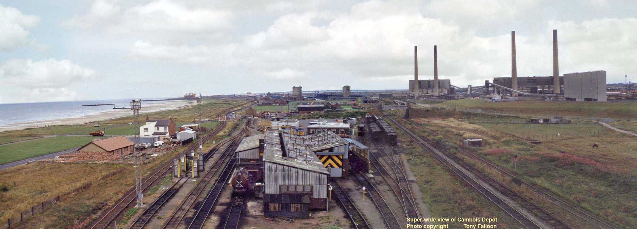
(Above) Despite a knee-knocking fear of heights, Tony Falloon managed to climb up one of the lamp towers at the north end of Cambois Depot to take this 'superb wide-angle' shot looking south towards Blyth. (Click on photo - then click a second time - to see full-size image).
It struck me immediately that in comparison to the steam shed, the diesel depot looks very clean…no ash heaps and coal scattered about the place and soot stains on walls. Also the depot seems small in comparison to the space taken up by North Blyth steam shed.
The Alcan pots are visible on the far horizon. Just to the left of the east most ash silo are the grain hoppers adjacent to Bolckows yard. Between the two ash silos the West Staith can be seen. Moving across from ash silos, we can see the West Yard which is full of wagons ready to discharge coal, but no ship is waiting at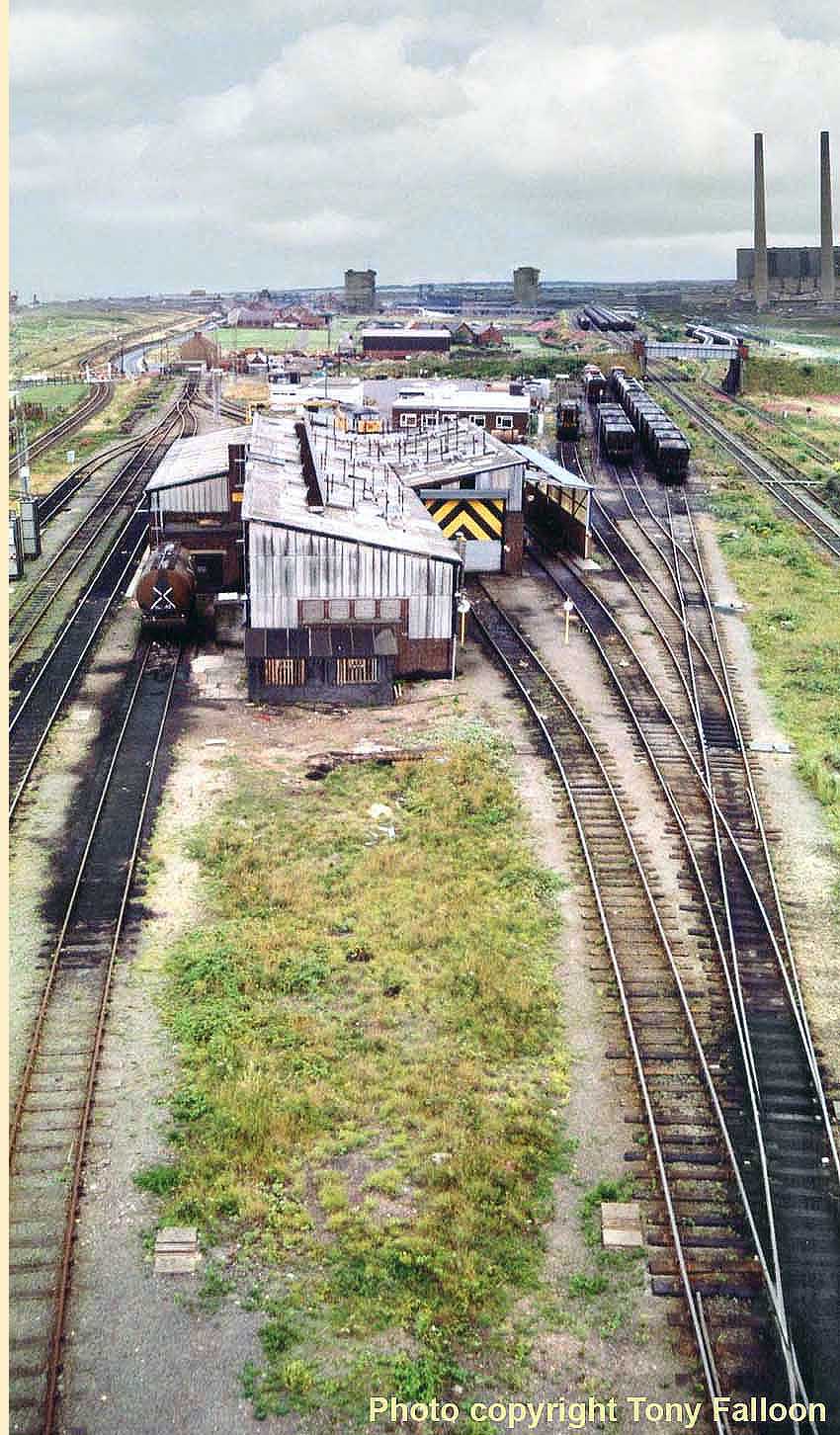 the West Staith. Judging by the empty wagons on the 'empties' lines perhaps a ship had not long left the port with a cargo of coal, though doubtless another one is anticipated later in the day.
The rear view of the power stations gives us an excellent perspective of the different sizes of the 'A' plant (left) and 'B' plant (right). It also gives us an impression of just how the structures dominated the surrounding area.
When returning from holidays the chimneys were usually the first sign that we were approaching home. They could be seen from quite a distance. The chimneys of the 'A' plant stood at 460 feet tall and the 'B' plant at 560 feet. The large 'box' to the right of the chimneys is part of the conveyor system installed in the 1980s. The power plants differed in their output too. The 'A' station had an output of 480 megawatts and the 'B' station 1250 megawatts. Their total combined output of 1730 MWs made them for a brief time the biggest power station in the UK, however the station was soon usurped by Ferrybridge 'C' when it went fully operational in 1966.
(Right) Concentrating on the diesel depot itself we have this next photo. By the time this picture was taken the whole of the Blyth area was suffering from decline in its various trades. I cannot see the above ground buildings of the Bates Pit on the far side of the river. Ship building had also ceased as had ship breaking. It was not long before the power station would be consigned to the history books along with the West Staith which had outlived the other staiths on the river by some 28 years. Demolition of the West Staiths took place in the autumn of 1995. Cambois depot's existence depended on the traffic going to the river at Blyth, so it was itself heading for the history books and is now sadly long gone. In this view the yard looks very quiet in relation to how it looked many years ago; I remember the days when it was full of wagons awaiting repairs and locos lined up waiting for fuel or other attention.
Tony Falloon's unique 'insider' views are quite remarkable...so too are Mike Hogg's reminiscences as Area Manager, North East Coal from 1990 to 1994. In April 1994, Sunderland South Dock closed, after 147 years, and Blyth Cambois after a somewhat lesser life, in August. The closures brought an end to the 56s and HAA sets heading south, while the staff contemplated retirement or transfer to other parts of what was still, just, British Rail.
But I'll let Mike take up the story...
Memories from Blyth's final Area Manager 1990-1994
by Mike Hogg
Hi Phil, I have just spent an hour immersed in your fascinating historical survey of the town, port and railway at Blyth. My involvement in this world was fairly brief and at the very end of the railway operation in the area - the small remaining operation on the North Blyth Alcan branch excepted. I missed by many years the amazingly varied events that your photographs show.
In November 1990, with twelve varied years of railway operations in Yorkshire and in Scotland under my belt, I was appointed as Area Manager, North East Coal, under the then British Rail freight organisation. The post was based at Burdon House, Sunderland, but was charged with the running of the remaining coal operation on both sides of the Tyne. What a great place it was, three or four hundred people shifting coal from the opencasts in Northumberland and from the rapidly closing Durham coalfield. As far as the Blyth operation is concerned a few memories:
Tony Falloon, who gives his account (above) of the tragic freight train collision near Morpeth which brought 56066 onto Blyth shed, ran a superb maintenance operation. We had 22 class 56s (the final 22 numbering up to 56135) which had been built at Crewe and were spot on for the job we had for them. Cambois supplied the maintenance for the fleet whether it was working from Cambois or from Sunderland South Dock. Heavy work was done at Toton near Nottingham. The North East Coal operation was a pretty independent one, insular even. As a non Cambois locomotive, 56066 turning up at the depot after the tragic accident at Morpeth was almost as much of a surprise as a Q6 turning up would have been.
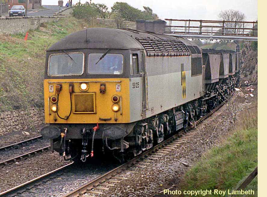 Most of Tony's staff could take you into one of their 56s and tell you the locomotive number just by 'knowing the inside'. An oil mark, the specific location of a notice etc would give the clue that this was, say, 56 125 - seen here (left) hauling a MGR train at Ryhope Grange; photo Roy Lambeth.
As a result the Class 56 fleet had a superb reputation for reliability and failures were rare indeed. One exception was on an occasion in 1993 when the shed roof needed repair. At the closedown of the week's coal haulage operation on the Saturday afternoon many of the 56s were stabled on the sidings shown in the photograph of Cambois depot. Just out of shot to the left is the sea. The weather on the Saturday night was foul with spray crossing the coastal road and soaking the locomotives with salt water. The start up on the Sunday was highly unusual - locomotives failing to start and 56s being ferried over from South Dock at Sunderland to help out whilst Tony's men dried them out.
Whilst some trip work was very local, the baseload work for Cambois depot (never locally referred to as Blyth - the order from the Control to a driver might be 'light diesel [to] Cambois') the money was made at the then inflated CEGB:BR contract rates by the long run down to Drax or Eggborough power stations in Yorkshire. At its peak, from the Northumberland opencasts and from South Dock/Ryhope Grange we'd run more than a hundred of these trains a week with the locomotive and driver coming off at York Yard North. An innovative train planning system was used in the area - arising from work carried out on a Sinclair ZX81 computer by a former controller at Cambois. 'Freight Maidens' produced the train plan week by week and indeed was 'exported' to that bastion of independence, the BR 'Yorkshire Freight' area - perhaps aided by the train planner at Cambois and that at Knottingley getting married!
A stalwart in North East Coal circles was operations manager Jim Richardson and with his untimely early death in 1992 a ceremony was held at Cambois to unveil a plaque to his memory on the side of 56134 Blyth Power. This will be certainly the first and last time that a marquee was ever erected at Cambois depot. A windy and cold day from memory but the right people turned out and Tony had bulled up the locomotive for its special day. I have a presentation OO scale model of it from that day still in my study at home (continued below).

(Above) Blyth power stations provide a very appropriate backdrop for this view of Class 56 No 56134 Blyth Power unloading an export coal train at Blyth Bates coal terminal on 14th March 1994. The two power stations at Blyth (Cambois) consisted of the older 'A' station (to the right) built between 1955 and 1960. The newer 'B' station (to the left) was commissioned in 1962. Both power stations had closed by 1991. Click HERE to visit the superb Ivan Stewart Collection on Flickr.
 (Inset) This cast aluminium nameplate measuring 45½" x 10" 'Blyth Power' as carried by BR diesel electric Class 56 locos 56076 and 56134, went under the hammer for £1,350 at a Sheffield Railwayana Auction in June 2009. Doncaster Works built 56076 in April 1980 and the loco received the nameplates in September 1982 during a special ceremony at Blyth Power Station. The plates were removed in October 1986 and transferred to the penultimate member of the class, 56134, built at BREL Crewe Works..
Continued...The last ever unfitted workings in Britain were handled by Cambois, these being the short distance workings to North Blyth. Despite the wagons having been built in the 1970s, we had to run them with a brakevan, sidelamp etc. the need for the lamp nearly caused a non-train-movement tragedy one day, which I mention below.
The Control and the train planning offices were within the small complex at Blyth Cambois that is in your photographs. There was real pride - the 'black diamonds' logo that adorned all 22 locomotives (as well as the national trainload coal fleet) had been laid in floor tiles in the lobby of the admin/control building. There were well kept lawns. These needed a lawnmower of course and we'd invested in a pretty natty petrol one. One winter whilst filling the side-lamp for the Alcan train (BR understandably never got around to designing a battery-operated sidelamp) our general duties leading railman used the petrol kept for the lawn-mower by mistake instead of signal oil and was lucky indeed to escape from the explosion of flame that resulted when the wick was lit.
In those pre-Railtrack days we also ran the signalling of the Blyth &Tyne including the passenger route down the Durham coast. The signalling was pretty much unchanged since the line had been first signalled including section signals not locked by the block and, of course, real characters controlling it all. However, as ever on the railway, we ran it safely and pride shone through.
A new route opened as late as 1992. The former Bates pit area had been partly taken over for a new outbound coal shipping point - I guess the last ever built in the UK. Diverging from the B&H mainline at Newsham, it required locomotives to run round there, much to the angst of householders in adjacent early 1980s housing estate who had been told by the housebuilders that the line was closed - an easy piece of patter when you're selling houses during the 1983-84 miners strike.
The senior railway manager in the area had, since North Easter Railway days been asked to sit on the Blyth Harbour Commission and thus it was that three or four years of fascinating maritime based engagement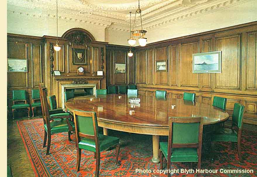 started. I met very many very long-served ship owners and others who would have recognised your photographs. The beginnings of the ideas on the re-opening of Battleship Wharf were sown at that time. Board meetings took place under the gaze of oil paintings of long-gone shipping worthies in the panelled boardroom (right) at the Commission's offices - it was extraordinary. As was sitting on the Commission's own dredger - MV Crofton - sipping gin and tonics on the flag-bedecked stern deck whilst she was moored at Jarrow Slake for the visit of the Tall Ships to the River Tyne in 1993 must be the oddest of my memories from this time. I guess the Crofton is now razor blades...
Back to the railway. Local independence shone through when, tired of trying to keep the weeds at bay, our area technical services manager 'acquired' a four-wheel steel-carrying wagon from the neighbouring Tees-Tyne freight area, mounted a large plastic tank onto its floor, along with spray nozzles at track level, did the various health and safety assessments and, hauled or propelled by a 56, commenced spraying all the sidings and running lines around Blyth. Top class effort. There'd be 101 reasons why one couldn't do this today on the privatised railway but our yards and run-round sidings soon looked a lot better throughout the area. Having been tied to the back of a set of mgr hoppers transiting to South Dock and having given that location a good spray, Cambois's initiative met its match when it demolished a (definitely foul of gauge!) shunting signal near Middlesbrough, was dumped at Tees Yard and never ventured out again. As far as I know it is still there.
The government's pit closure announcement on 12th October 1992 was the watershed moment whilst I was in the northeast. The coalfield had been contracting for decades and even the Northumberland opencast was facing increasing planning pressures. The defence of the coal operation was eventually to fail and the next year or so was spent clearing coal stocks, negotiating severance deals with staff (some drivers left with just over fifty years service) and arranging alternative work throughout the northeast's railway for those too young to retire. It proved to be the corporate railway's last hurrah in the northeast and to my teams great pride every one of remaining 333 staff either retired early or was found an acceptable alternative job in the northeast with the passenger railway or at the remaining freight depots at Tyne and at Thornaby. The Sunderland operation closed first, the offices closed on 31 March 1994 (we literally turned the lights out and went to the pub). South Dock depot closed two weeks later (having been open since 1847) and the Cambois control, offices and depot were finished by the August. The remaining coal operation was managed from resources at Tyne Yard with the control at Knottingley. Today there is the odd train movement on the Blyth & Tyne but a mere shadow of what it had been.
I was the last of the three Area Managers for the coal operation, my predecessors being Gordon Dennis and Cath Gregory. All of us thought the world of the place. Cradle of the freight railway in the early nineteenth century and still a super place to run freight trains in the early 1990s with exceptional attitudes from all involved. I'm still in the rail industry, though far away from freight and from Cambois, but even so I regularly bump into former colleagues - people with fond memories of what was achieved there.
Thanks again for constructing your website. Just typing out this note has brought back a stack of great memories. I hope that they are of interest to you though they do come right at the end of the operation you have described.
Regards Mike Hogg
Dunnington, North Yorkshire.
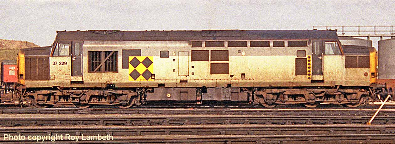
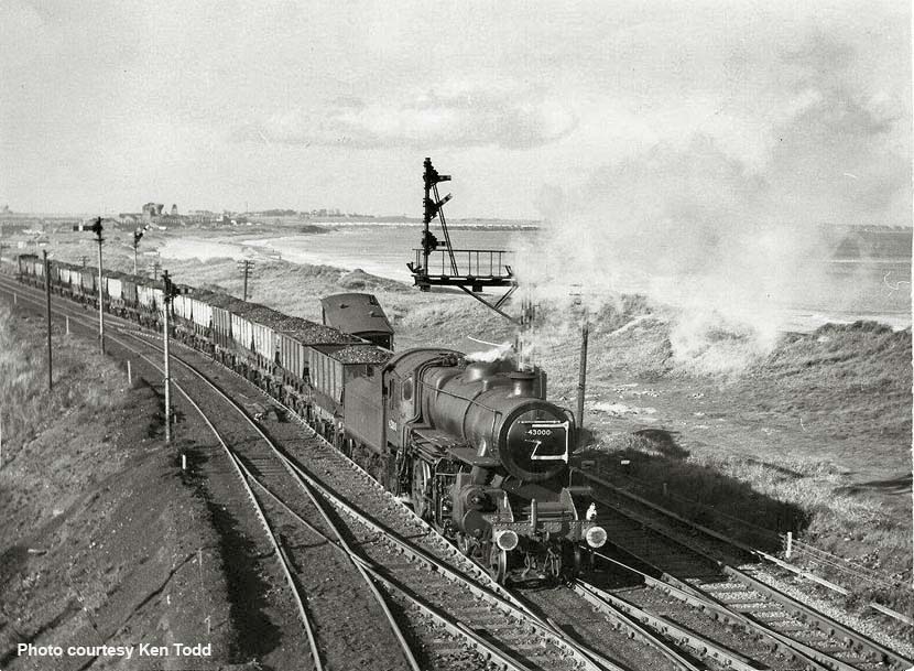
(Above) A beautiful crisp sunny day for Ivatt Class 4MT 43000 as she lazily coasts south with a nippy tail wind on the approach to North Blyth Sidings with a rake of loaded wagons and a brake van, the coal destined for shipment from the North Staiths. Note just behind the tender the roof of the brake van at a precarious angle. It seems that the van was being used as an improvised buffer stop on a short stub of track which continued beyond the set of points just out of shot in the bottom right hand corner of the image. There are not many clues to help date this scene. We know that steam ended at North Blyth in 1967. The locomotive also gives us some clues. She was withdrawn from service on the 30 September 1967 and cut up by the end of November that year. Her last shed allocation was 52F North Blyth. One interesting and significant point to note is that the smoke-box door hinges have been painted white. Two locomotives namely 43000 and one of her sisters 43063 were 'spruced up' and took part in hauling the 'Wansbeck Piper' special charter from Morpeth up to Reedsmouth Junction on the 2 October 1966, so I believe that this photo was taken not that long after the event. The buffers clearly still have remnants of white paint on them too. Another point of interest on the left horizon is the collection of buildings that were Cambois Colliery which was nearing closure at the time this photo was taken. The pit was closed 22 April 1968.
Fred Wagstaff adds his comments: 'This loco is the best 4MT ever built; it was a real pleasure to work on and would steam on a nightlight…nice picture too. Taken from the footbridge at North Blyth, it shows Cambois Colliery washer in the distance and Sandy Bay Caravan Park in the extreme distance on the North side of the River Wansbeck. The Van on the Beach side was the result of a collision a few days earlier...'
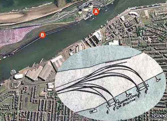
(Above - Below) Returning to the 1934 LNER map, we venture out onto the North Staith with all its spouts clearly numbered 9 to 16 from south to north. A short stretch of the C&C line can also be seen, which leads us onto the next map superimposed over a Google image (right) with the letter 'B' indicating the position of the North Staith and 'A' the site of the Cowpen Coal Co. staiths in 1934 with spouts Nos 1 - 4, believed to be the very first to be built in the harbour for the shipment of coal.
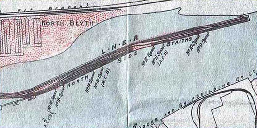
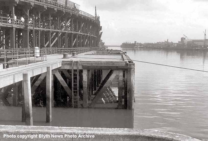
(Above) For the benefit of rail enthusiasts, perhaps a summary of Blyth's railway history is required at this juncture if only to explain the origin of the staiths. Indeed, the harbour was being used to ship coal from the local mines long before the Blyth & Tyne Railway (B&T) was fully operational. There were various wooden waggonways that provided a route to the harbour for the movement of cauldron wagons then in use. Since access to the network of railways to the south and the Tyne was not possible, an improvement in transportation was desperately needed and in 1842 an iron hulled steam ship 'Bedlington' was built. This vessel could be loaded with 40 cauldrons of coal for shipment down to the Tyne where it offloaded the cargo into other vessels by means of its own derricks. This task proved to be both costly and tedious, and in order to solve the problem a railway line was proposed from Blyth to North Shields at the mouth of the Tyne, however that line never came to fruition. Instead a track was laid from Blyth via Newsham and Hartley to connect with the already extant line at Seaton Delaval which was then extended in 1847 to join the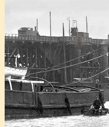 Seghill Railway giving a through route from Blyth direct to the Tyne at Hayhole, a distance of some 9 miles. The Blyth & Tyne Railway Company finally came into existence by Royal Assent on 30th June 1852 and began operating over 13 miles of track from 1st January the following year. By 1872, following various acquisitions and extensions, the B & T had a total route mileage of just over 43 miles. This view from the North Staiths is looking downriver towards the South Staiths on the opposite bank.
(Below) Blyth's maritime history is an interesting subject and it is all too easy to lose sight of the fact that this is primarily a railway site. For that reason, I have included this blown-up shot of a Class J77 0-6-0T on the North Side Staith. This is from the image below showing HMS Thunderer arriving at Blyth for Hughes Bolckow late 1926. Sold for scrap she was stripped of her heavy guns and lots of other fittings at Rosyth to make her draught suitably shallow for Blyth harbour, however she still touched bottom on arrival at the harbour entrance and it took six days to make her light enough to tow up river to Bolckows.Click (here provide link) to see the full size image of the ship being towed by tugs to the breakers yard - the Class J77 0-6-0T and 20 ton coal wagons pale into insignificance in the background. The Cowpen Coal Co spouts can be seen just behind the stern of the warship.
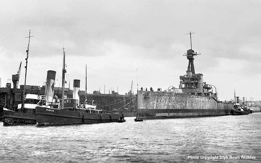
(Below) The problem with Blyth harbour was the shallow water. As early as 1877 the Harbour Authority recognised the risk of losing its lucrative coal traffic to other ports, hence the Board of Commissioners had the harbour deepened to accommodate larger ships. In 1884 part of the south staiths were built which completely changed the fortunes of the town, and in that year alone 252,780 tons of coal was exported from the south staiths. This was a massive increase on the previous year (before the upgrade was completed) as only 42,176 passed through the harbour. By 1886 the export of coal had risen to 429,961 tons, and a year later it increased to more than 466,983 tons - a considerable achievement in view of a 17-week strike by miners! The south staiths were extended in 1888 and a new line built out to Newsham to improve access to the harbour for rail traffic. Export was growing at such a rate that the North Staiths were built in 1896, Blyth Station was rebuilt and opened in 1896 which included a new Blyth South engine shed of three roads followed by the opening of a new engine shed at North Blyth a year later. Business continued at a steady rate and it soon became apparent that another staith was required to meet the demand, hence work commenced on the construction of the West Staith in 1928. This view shows a vessel beneath Spout No 16, its hold already full of coal while a newly-launched 'King Theseus' with decorative bunting provides an interesting backdrop.
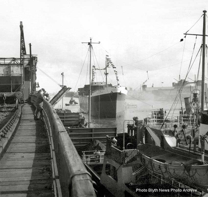
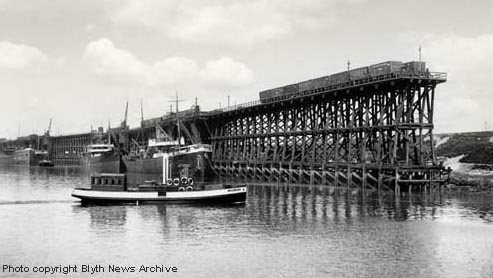
(Above-Below) With so much of Blyth's railway infrastructure consigned to the history books, artists and railway modellers, and historians in general, for that matter - have a difficult task in researching a subject that no longer exists. Instead they must rely on a good quality photograph from bygone days in order to create an accurate prototypical appearance of their work. Having searched through the Blyth News Archives, there are certain photos that stand up to scrutiny more than others, including this one of the North Staith which immediately draws in the eye and demands closer inspection - the detail is superb! So, for the benefit of connoisseurs, the low-res photo (above) is the overall view, while it is hoped the photo (below) will show plenty of detail that will satisfy even the most fastidious rivet counter, including those on the North Eastern Railway 8-plank mineral wagon - well, at a pinch! There is only so much you can do to a high-resolution photo without overloading a web page. The photo (below) is a 'super-wide' close up of the vessels berthed at the staith. For the record, these 8 plank wagons were the most numerous design of coal wagon built in the UK after 1923. They could carry 12 tons and had universal dimensions of: length of 16' 6", width of 8' 0" and wheelbase of 9' 0".
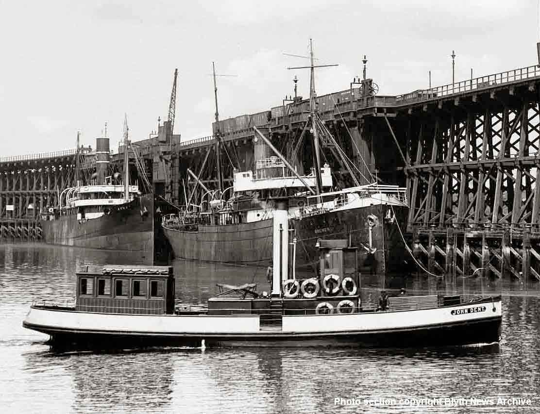
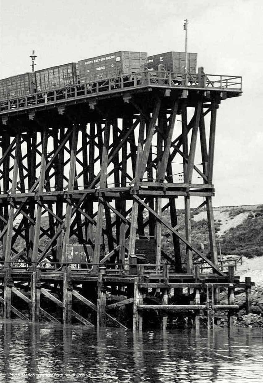
(Above-Below) Images of the staiths' intricate detail are wonderful to look at, and it seems incredible that they could support several laden coal trains simultaneously. I was also astonished to read on Fred Wagstaff's 'BR Steam Footplate Memories' that a ship had hit the staiths when it was launched from the shipbuilders yard.
Of course being a nosey individual, I just had to learn more about this incident and the date it happened. Well, with the help of various people still in the town of Blyth and a lot of Internet research I have learned what took place and when. In 1946-47 Wahl of Norway commissioned the building of a ship from Blyth Drydock and Shipbuilding Co. After design and build the vessel was eventually launched as the 'Nusken' in 1948 from the slipway at Blyth. Drag chains are usually attached to ships on launch so that control of the vessel can be maintained, however in this instance the rusty (60 year old!) main drag chain snapped leaving most of the chains and piles behind, and the ship was set free to go anywhere it liked! Its momentum on launch carried the ship across the River Blyth and it crashed into the North Staiths on the opposite bank of the river in the region of spouts 12 & 11.
It is amazing that a more serious incident did not occur as a result of the collision. The staiths - as 'flimsy' as they look - withstood the impact and although quite a number of timbers were shattered the staith survived and remained standing, testament to their structural integrity and strength. This picture was taken after some tidying up had been done in readiness for repair but it still shows the extent of the damage.
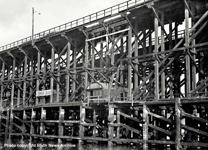
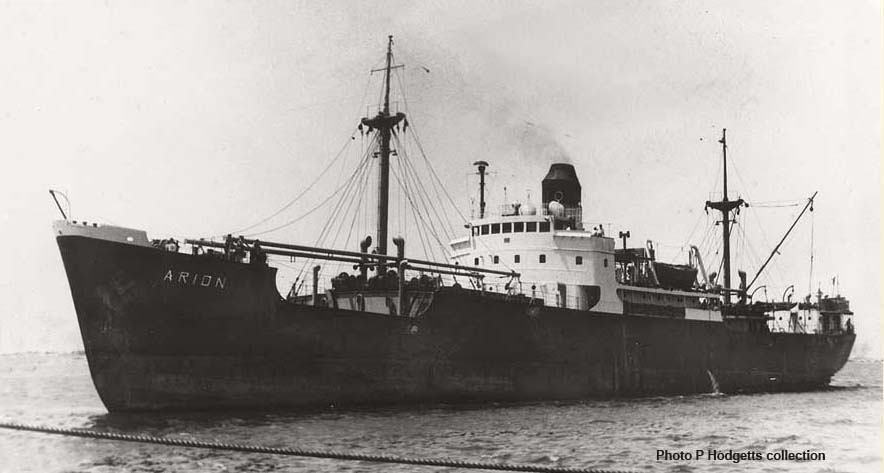
(Above) Following its inauspicious launch at the Blyth Drydock and Shipbuilding Co, the 'Nusken' changed hands and its name a few times during its service life. In 1955 it was sold to a Finnish company and was renamed 'Hamno'. It changed hands again in 1966 to a Greek company where it acquired the name 'Arion' and probably spent the rest of her working life in the Mediterranean, then just a year later in 1967 it was sold to a company in Israel where it was renamed 'Dolphin' and it appeared on an Israeli stamp! In 1968 it was sold to a Liberian company and became 'Dolphin II'. She was sold for scrap in 1972 after 24 years of service and ended her days at Split in what was then Yugoslavia and is now Croatia. Split interestingly is in the County of Dalmatia where Dalmatian dogs are from! Details of the ship and a resume of its life - including a photo of the vessel on the Israeli postage stamp - can be found here.
(Below) This is a wonderful early picture taken by a plate glass camera of the Cowpen Coal Co staiths. The staith at which the collier is moored is in a state of reconstruction; there are no safety rails or tipping gear installed for unloading the cauldron wagons. This redevelopment took place after 1897; I have a reprint of the 1897 OS Map sheet No 73.10, which shows the the staith to be in the staggered setting as per the picture. The wooden vessel is empty and high in the water, therefore we can safely assume it is waiting its turn at the other spout where the steamboat is moored. These C&C staiths were first built on this site (known as Bishop's Quay) in 1865-6 when Cambois Colliery laid a railway to the harbour for the shipment of coal. In this 1900 view, the photographer captures the process of major alterations at a time when the river and navigable channel was being widened; this work was coincident with cutting back the staiths and foreshore. The staiths went through various partial or total rebuild over the years and occupied the site untl the mid 1960s. They were eventually demolished to make way for the Alcan terminal.
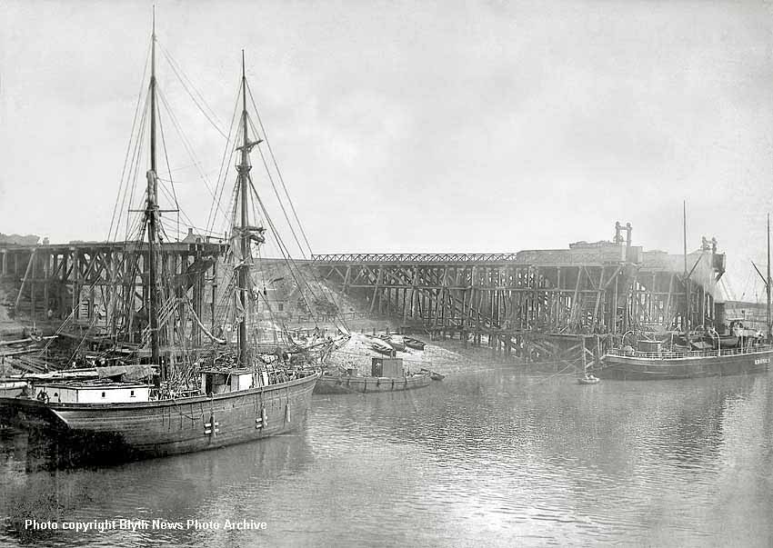
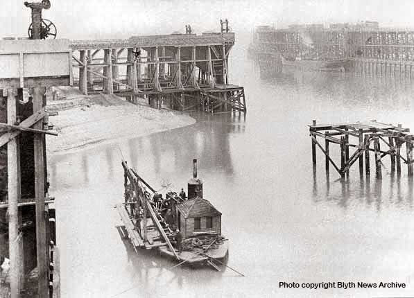
(Above-Below) The image above was taken circa 1880. It shows the two staiths as they were built in 1868 occupying the site that was Bishops Quay. It is quite evident that the north-most staith is much shorter than the one to the south, which is the one that had to be cut back enabling the widening of the river and dredging of the navigable channel. Also of interest is the harbour drilling craft, used to drill holes into the solid rock of the riverbed in which charges were placed to blast/break up the rock thus making it easier for the rock breakers and dredgers to do their bit in keeping the navigable channel open to ever increasing sizes of ship. (Below) This image shows the completed reconstruction of the C&C Staiths northern most spouts. It appears the work has recently been completed since the vegetation hasn't had chance to grow on the banks surrounding the staith. Also the Blyth tug boat Bothal can be seen, the vessel named after a castle on the banks of the River Wansbeck not far to the west of Ashington. It is a shame that the southern spouts cannot be seen in this broad view.
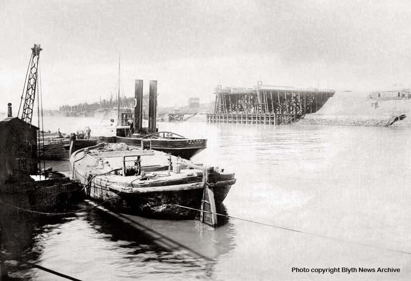
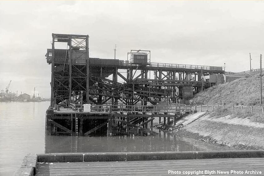
(Above) As mentioned above, Cambois Colliery erected the new staith as close to the mouth of the River Blyth as possible and at a point where the deepest water was available on the north bank of the river, which also provided shelter from the north shore and the sea. The first coal to be shipped from Blyth at these staiths took place on 27 June 1867. The Cowpen Coal Company was taken over by the Mickley Coal Company in 1928, though it was still referred to locally as the Cowpen Coal Co. Following an extensive survey, the new owners announced a total reconstruction of all the collieries in the Cowpen group, which led to Cambois Pit being virtually rebuilt and the staiths improved. This view looking north from mooring stage No 30 shows Spout No 4 in the early 1960s. By this time the riverbank has been graded and protected with stone. Today the whole site is gone and is now occupied by the Alcan terminal.
(Below) On the opposite bank was the LNER South Side Staiths, which provided by far the best vantage point of ships been loaded beneath the C&C shutes. When it came to dismantling the South Side Staith on the quayside in 1966 the contactors had a major problem as many of the supporting timbers had rotted. It is incredible to think that countless heavy coal trains had been on the staiths in that rotten state only two years prior to demolition! My dad remembers the staiths in use and trains on the bridge crossing Turner Street in Blyth, but doesn't remember them being demolished. Funny how some things he remembers and not others. I'd have thought the whole town would recall a major undertaking like the demolition of the staiths, since they were a major feature of the landscape for generations. I was born in July 1968, the very last month of steam on BR and so I missed it all the fun of the fair. However, I do remember riding my bicycle down to the quay side as a small boy in the 1970s, and although the staithes were long gone by then, various terraces of buildings were still there. It was interesting to watch the boats being unloaded at the Alcan Terminal on the opposite bank. Dad worked at the Seaforth Street Council Offices and at lunchtime walked down to the riverside to watch the Alcan silos being built. The construction work took place between 1969-71. The first 5000 ton cargo of alumina arrived at the terminal on the 29 June 1971. . This aerial view shows the demolition of the coal drops Nos 1-4. The clearance work was to make way for the new Alcan silos and terminal. Note the remnants of the North Side Staith, whilst in the bottom left corner the three dry docks can also be seen as can the route of the staith from Blyth Station through to the riverside. Note also that the Seven Stars Inn is still there on the far right, but its days were numbered too as it was eventually demolished. Details of the activities of the vessel can be found in the caption below...
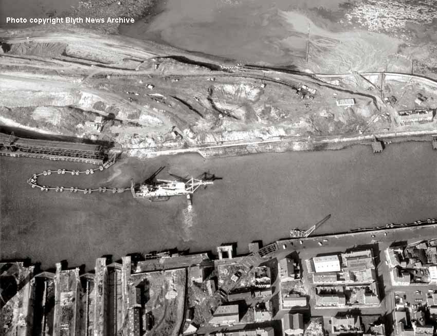
(Above) The vessel in the photo is a 'floating cutting platform dredger' - a suction dredger named 'Beverwuck 31, which is fitted with an additional cutting/drilling head. It will be drilling and cutting away at any bedrock where the new Alcan terminal is to be built; the rock/gravel created in the process will be sucked up and washed away through the floating pipework trailing out from the stern, which discharges the dredged materials onto the seaward side of the spit of land at a point where we can see the rocks of the Shinny Gripe Lug that make up the solid rock of the harbour floor. Prior to dredging, a deep trench will have been cut and piling driven into the ground or as far down as the bedrock to allow reinforced concrete capping to be added. In essence the wharf side was already built before the dredging took place, and once set, the dredger could then work up to the pre-prepared wharf edge. On the opposite bank is the BHC crane and floating sections of the suction pipeline that were not in use at that particular moment in time. I wonder how the workers who rebuilt the C&C staiths would have felt seeing their beautifully graded riverbank completely destroyed? Progress I think it is called.
(Below) In the colour view below we can identify the vessel, which was of Dutch origin. The red barrels on the deck perhaps contain grease or hydraulic oil for the machinery. To the right, the nozzle is in the water and dredging is taking place. I expect the operation was very noisy with heavy machinery in operation on the platform itself. On the blue sign to the left of the vessel is the name "Dredging" but sadly nothing more than that. One can also see that the concrete capping of the piled wharfside becoming visible. On the 'stern of the vessel are two high rusty columns (legs) that are dropped down onto the riverbed for stability. The North staiths of course were out of use when this work was being done and the staiths on the South side were already demolished as can be seen in the picture above. That information tells us that it is after 1967. The white car is a Ford Anglia.
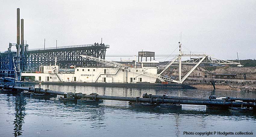

(Above-Below) These four colour photos show the Alcan Terminal at various stages of construction. In the first shot, the dredging up to the new quay side is complete and one of the larger silos is in the process of being built. Unlike many of today's building sites and roadworks, closer inspection reveals a hive of activity with men at work, crane booms lifted high and a digger and dumper truck busily employed, whilst the pilot boat heading downstream adds to the sense of movement and industry. At the time the Government was under Labour control with Prime Minister Harold Wilson at the helm. The Government remained in Labour's hands under James Callaghan until the 'Winter of Discontent' 1978-79, which heralded the start of the Thatcher years. Of course, the change in Government meant nothing to me as a small boy, but I realise now that the Oil and Energy Crisis of the 1970s was a very interesting time. Having to eat by candle light during the blackouts was great fun, though I doubt my parents felt the same! Fortunately, we were moderately self reliant since we had a coal fire with a back boiler, no gas central heating, and as long as we had coal and wood we were able to keep warm and wash in hot water. I remember my grandfather in Gosforth had the most amazing shed on his allotment. It contained a pot bellied stove, an old comfy sofa piled high with books and magazines, a radio for the cricket and a small portable black and white telly from a caravan that ran off a 12v car battery. Winter of Discontent, I think not - it was a shed in heaven! Meanwhile my dad had an extensive garden and my mother baked a lot, so despite the queues for bread at the bakeries we were not overly troubled by the problems. I remember the smell of mum's baking whilst playing out in the back street and having fresh bread hot from the oven spread with butter that melted in your mouth. The thought of it still makes my mouth water! The second shot (above) shows all silos nearing completion. The quay side is complete and construction of the offloading facility is well on the way. The third photo (below) shows what I believe to be the first delivery of alumina at the terminal on 29th June 1971. Note the North Staith on the left - officially opened 13th July 1896) - is still standing; demolition didn't begin until 1972. Interestingly the staiths were not constructed of oak, but of pitch pine - a hardwood. The piles of the staiths driven into the river bed were of pitch pine greenheart, a very hard a resinous timber well suited for the conditions of water and strength required of them to support the weight of the staiths and coal trains. The final shot shows the newly completed terminal and silos.

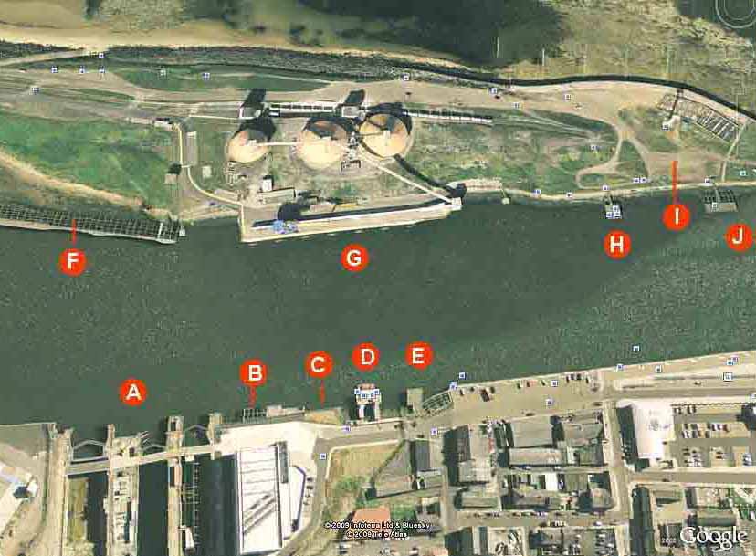
(Above-Below) In this Google image taken on the 14th July 2006 it is quite incredible that in the 32 years since the earlier aerial photo (featuring the Beverwuck 31 dredger above) was taken that much of the area is still recognisable! In the bottom left hand corner marked 'A' are the three dry docks, which have been bridged for ease of access to what was Cowpen Quay, and just to their right is a modern rectangular building on the site of High Quay with mooring stages 18 & 19 marked (B) where the Mid Ferry crossed the river. The Tug Spout (C) is gone, but interestingly the roads and new buildings fit in well with the alignment of the old railway that once served the South Staith. 'D' marks mooring stage 17, which is now used by the Blyth Volunteer Lifeboat, 'E' is mooring stage 16 and to its right the timber structure of the south staith can be seen curving out into the river. The staith is covered over and vehicles are parked on the actual structure, so incredibly despite losing its rail traffic in 1964 the staith is still in use 112 years after construction in 1888. New investment has improved the derelict area considerably, and many of the streets and buildings are still standing as they were in the 1974 view. Moving up to the opposite bank 'F' shows the remnants of the North Staith, 'G' shows the Alcan Pots built on the site of the old Cowpen Coal Co staithes. 'H' and 'J' mark the mooring stages 31 and 32 - and 'I ' is the site of the Seven Stars pub. The old C&C lines can still be seen, albeit reduced to a single line since the 1934 plan was drawn, while the shoreline and sea wall (upper right) remain relatively unchanged. One would have thought that storm damage and shifting sand on the shoreward side might well have altered the sea front over the years, but it has not. Click on image to view full size. (Below) Another section of the 1934 LNER map showing the network of lines serving the Cowpen Dry Docks and Shipbuilding Co Ltd.
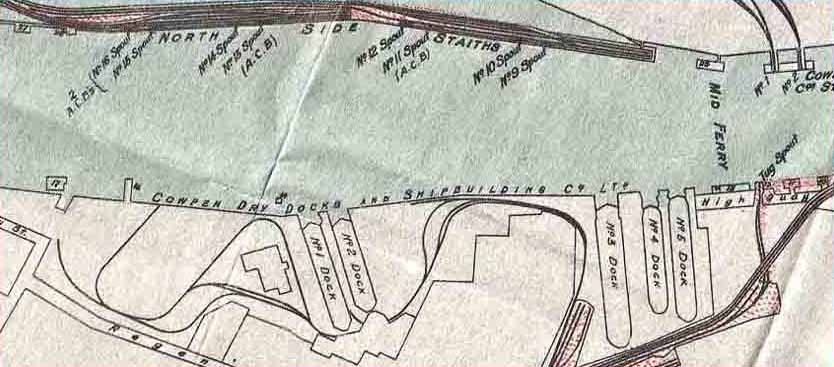
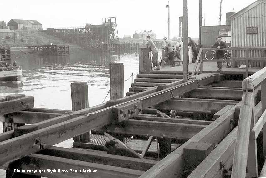
(Above) This is the Mid Ferry - a motorboat service operated by the Blyth Harbour Commission (BHC). Just behind the ferry (out of picture on the left) is Cowpen Staith Nos 1 & 2, beyond which is mooring stage 30 and beyond that Cowpen Staith no 3, but it appears that No 4 has gone. In the far distance can be seen the terrace including the Seven Stars pub. The main feature in the foreground is the huge timberwork of the ferry landing point and mooring stages 18 and 19. Just look at the size of those bolts in the wooden block connecting the two timbers together! I'd like to see the spanner they used for tightening those, a bit bigger than a ¾" Whitworth I think. The timberwork can still be seen on the Google 2006 map just south of the three dry docks, which are immediately behind the photographer. Judging by the lady in her coat waiting for the ferry (a Hetty Wainthrop lookalike with a tug funnel rising from her head) I would suggest a date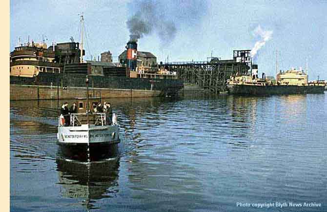 of mid-late 1960s, though there is no way of telling if the Beatles might be on a nearby radio, or even the scent of Flower Power. This looks more like the business end of the era, including the chap facing us with his flat cap and bicycle clips!
Everyone seems quite relaxed in this scene; the pace of life has changed beyond recognition since those days.
(Right-Below) The first ferry service across the river began in 1867. A vehicle ferry has operated between Blyth and Cambois for almost 100 years until the 30th June 1964, the same year that the North Staiths were taken out of use. The replacement passenger ferry service (right) is being operated by motorboat BHC No 5, one of several such vessels owned by the BHC. When these were taken out of service, a request was made by the local authority to the House of Commons in 1970 for a grant to operate the Blyth-Cambois Ferry Service. Here is a summary of what was said:
Mister Edward Milne (14 years MP for Blyth) asked Albert Murray, Parliamentary Secretary to the Minister of Transport, what financial assistance his department was prepared to provide for the running of the ferry service between Blyth and Cambois.
Mister Albert Murray, replied - 'The local authorities concerned have enquired whether they would qualify for Government grant (under Section 34 of the Transport Act 1968) in respect of any financial support they might themselves give to the ferry. The detailed information is being studied and we hope to reach a decision soon.
Mister Milne then asked if he would endeavour to speed up the decision on this matter in view of the importance of this ferry service to the two areas concerned. Mister Murray replied that he was aware of the local authorities desire to act speedily, but since this is the first application of its kind it needs a great deal of detailed study...
...the first application of its kind!
Blyth seems to have been a place of many firsts…an innovative town. However, taking into account the Governments lamentable record of snail's-pace decision making - it looked as if the ferry service was to be lost, but as a young boy in the 1970s I remember a rustic little vessel (left) that ferried no more than a half dozen people between Blyth-North Blyth and Cambois, albeit the meagre shelter it provided for passengers was little more than a tarpaulin sheet stretched over a metal frame...in essence a floating tent! In this photo the cropped state of the North Staith and the rows of terraced houses are just as I remember them on the north side of the river. The last ferry service across the River Blyth ceased in 1997 after 130 years of operation in one form or another.
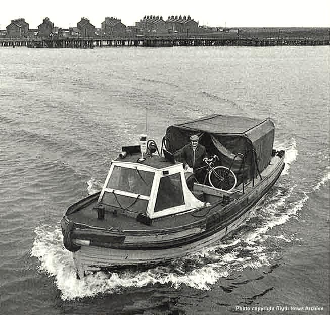
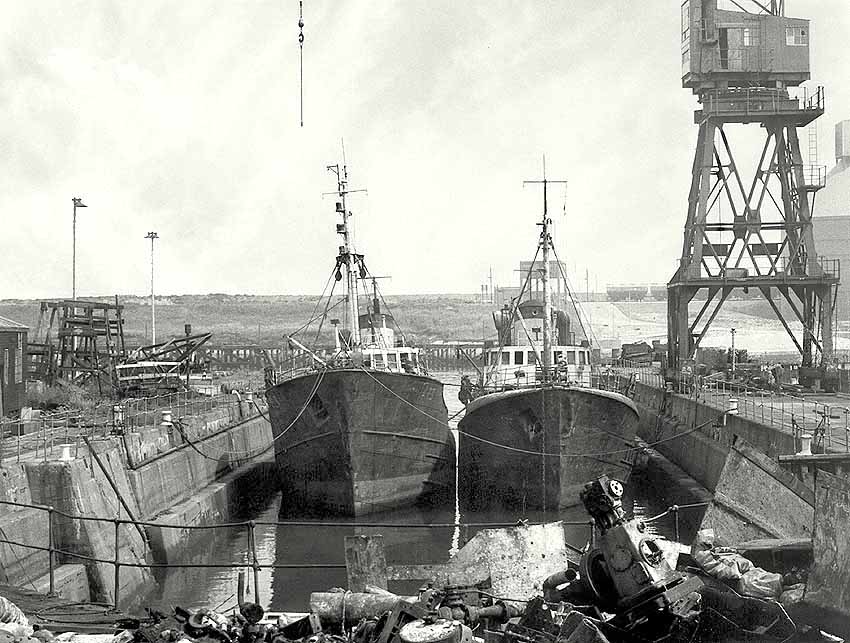
(Above) Why these boats are in the Dry Dock isn't immediately apparent. First thing of note is the tide is near the high water mark and the dock gates are open. Lots of things are laid about the dockside, so I am certain the boats are here for repair. Note the battered the railings in the foreground! However if one looks very closely, the crane door is open and a cable from the crane is hanging free above the boat. Something has been lifted or is about to be, but whether that is on or off the boat is uncertain.
Looking beyond the stern of the boats to the opposite bank is the remnants of the North staith, which, given the photographers perspective leads me to believe that the image is of the middle (No. 4) dock. Also visible on the other bank is a rake of Alumina wagons at the Alcan site, and the north most 'pot' of 7,000 tons capacity just to the right of the crane.For the record, the name 'Alcan' is an abbreviated name taken from Alumina Canada. The company (now called Rio Tinto Alcan) is an Anglo-Australian mining concern, which bought 80% of Alcan for £19 billion and is now the world's largest producer of aluminium and bauxite. The Alcan Depot at North Blyth is where two of the products needed for smelting are imported, including bauxite from South America which travels to Ireland where it is made into Alumina by a chemical process, and then shipped to Blyth. The other basic material required is calcined petroleum coke, imported from the USA. Both materials arrive in ships of 20,000 tonnes and are unloaded into one 7,000 and two 15,000 tonne storage silos called 'Pots', which have been a familiar landmark on the coast at Blyth for over 35 years. The alumina is then transported from Blyth in specially designed rail wagons to the Lynemouth, Lochaber and Kinlochleven smelters in Scotland. The coke is taken by road to the Lynemouth carbon plant to produce anodes for both the Lynemouth and Lochaber smelters. The creation of aluminium requires vast amounts of electricity and any surplus at the Lynemouth plant supplies the National Grid. The Alcan wharf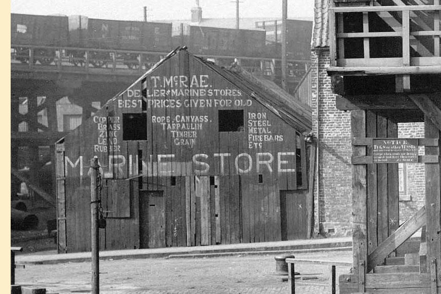 dates the picture to post 1975, but not much else helps date the image more precisely. Sadly the names of the boats are not visible on their bows, not even their harbour numbers.
(Inset Right & Below) This photo of the Tug Spout fascinates me - what a wonderful picture! The intricacy of the wooden structure, the stairway and winding mechanism with a counterbalance weight hanging to the right of the spout can be seen in incredible detail. Just look at the rivets on the spout. To the left of the spout is a rake of NE Railway wagons on the elevated section, curving out onto the south section of the riverside South Staiths, and I love the wooden shed belonging to T McRae, Dealer in Marine Stores (Inset Right) and the close up detail of Mister McRea's Ikea-style advertising adds a nice touch. To the right is a row of terraces. I wonder what it was like living next to all that heavy-duty rail activity? Just look at the upper left bedroom window, it is wide open! And then there's the cement pointing on the front of the house? It suggests that the frontage has been changed, possibly from a shop? There is a vertical joint in the brickwork where the terrace houses meet, and just to the left of the drainpipe, the pantile roof is very straight and of a different hue - again suggesting a newer roof to that of its neighbour. On the tug spout itself a chap is observing the photographer. The railway wagon on the spout helps illustrate how the contents of the wagons on the staiths dropped their contents from the doors on their undersides and gravity would take the coal down the spout into the waiting vessel. The noise must have been deafening to local residents, particularly at night when the neighbours where in bed! Perhaps that is the instruction on the notice board; it's difficult to read, as too is dating the image. I would say it is early 1900s.
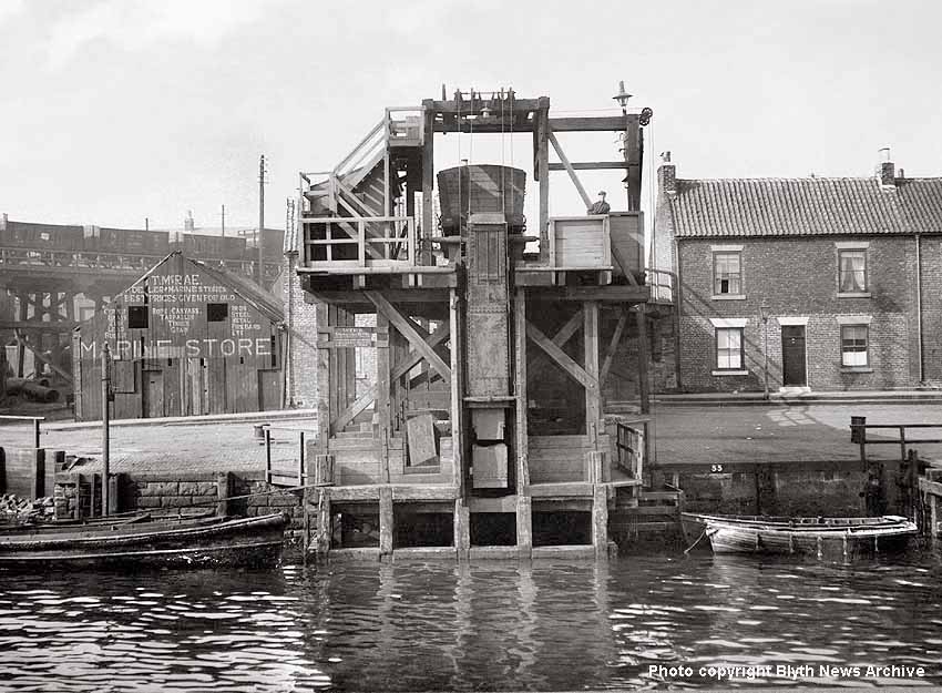
 It is always wonderful to hear from ex-pats of Blyth. It is good to know that this concise history of the town stirs so many fond memories for so many people. Clearly I am not the only with rose-tinted spectacles when it comes to memories of Blyth and the surrounding area.
One such gentleman is Malcolm Gibb, who writes...
'Dear Mr Hodgetts, I have just spent a most enjoyable few hours reading the on-line article in which you reflect on Blyth's history. Your descriptions and the pictures you have chosen to illustrate the article have brought a flood of memories back to me. In particular, the photos of the High Ferry brought a host of memories, both visual and olfactory. The smell of hot lubricating oil and diesel, from standing in the doorway of the engine room, is still locked into my long-term memory. I thought therefore that I must write to thank you for taking the time to compose this article and to declare my interest in the subject matter. It seems that memories of growing up in Blyth has frequently left indelible memories, at least in boys who had the freedom to spend hours playing or fishing around the quaysides and staiths. Unlike you, I did not actually grow up in Blyth, although both my father's and mother's families went back several generations in Cowpen and Blyth. However, I do have memories of the town and surrounding areas going back to about 1950.
The remains of my great great grandfather, great grandfather, grandfather and father and uncle rest in Cowpen Cemetry. Likewise, my mother's grandfather and father are also interred there. My mother and father both grew up in Blyth and married at the very beginning of 1939. My father had already succeeded in acquiring a post as a teacher in West London so they moved there straight away. I was born and grew up in West London, but retained something of a northern accent from my home environment, according to school pals. However, at every opportunity during the school holidays, between the ages of 5 and 16, I would travel by train from King's Cross to Newcastle, and then by bus to Blyth to stay with my grandmother who lived in Middleton Street. My paternal grandfather had been a monumental sculptor in Blyth until he died in 1947. Happily, many of his works still stand proudly in Cowpen Cemetry. My father's eldest brother and his wife lived at Shankhouse. They were both great favourites of mine and my uncle in particular used to take me around Blyth and on excursions by boat from the Tyne Commissioners Quay to Tynemouth and back. In those days the river was lined with ships in various stages of being built.
On my mother's side of the family, her father had started his working life as a lamp trimmer at Cowpen Colliery, before serving his apprenticeship as a saddler. He then made and repaired the harnesses for the pit ponies at the same colliery.
Thankfully, my father gave me my first camera when I was about eight years old, although unfortunately my pocket money didn't stretch sufficiently to buy a lot of film in those days. How times have changed with the advent of digital imaging! Nevertheless, I do have a few photos which I took whilst running loose around the quayside on the west side of the river under the staiths. What I do regret is not having taken many photos around the town or while playing on the rocks at Cambois at low tide. If you think any of these photos may be of interest to you, then please let me know and I shall be pleased to send them to you.
Thank you once again for taking me on such a wonderful trip down a very fond memory lane.
Yours most gratefully, Malcolm Gibb.
P.S. I do have a second cousin living in Park View, Blyth by the name of George Robson. His grandfather, father and elder brother had each in their turn owned Robson's Shoe Shop in Waterloo Road...'
THE HISTORY OF COWPEN & BLYTH CONTINUES ON THE NEXT PAGE...CLICK ON LINK BELOW
Philip Hodgetts recently contacted the site to comment on Fred Wagstaff's memories of North Blyth Steam Shed and Cambois Diesel Depot. Phil's quite obvious enthusiasm for Blyth is infectious - his love of the Northumbrian town shines through, and so I am pleased he has agreed to input his childhood memories on this site. Although Phil was born long after Blyth's heydays as a major port, his research into the compilation of this page has been an interesting journey for him - and a most rewarding one for the both of us. Indeed, it is encouraging to find a relative youngster (Phil was born in 1968) doggedly determined to investigate Blyth's place in history and share it with others. The page has grown from a tiny seed of an idea based on a superb 1934 LNER Plan of Blyth that Phil purchased on eBay (see below). Perhaps some readers may find a few inaccuracies along the way, therefore if you wish to discuss the contents of this page, Phil's email address is at the bottom of the page. Meanwhile I'll let Phil take up the story...

(Above) This is the 1934 map of LNER-owned property around Northumberland's Blyth harbour and river. The LNER property is marked in red whereas other private railways have no colour. The map itself is quite fragile and it is printed on what I can only describe as greaseproof paper. The map is not on the usual alignment since the North is off to the left in the top left corner of the map. Therefore, working our way from left to right (north to south) we have initially the West Staith (with spouts 17-20) protruding into the River Blyth on a more or less north-south alignment.
To the north of this staith was a large selection of LNER sidings but for some reason they have not been included in this map. However, the map does show the village of North Blyth with the vast array of sidings that were used to shunt loaded coal wagons out onto the North Staith (spouts 9-16) and return empties. The sidings also had a connection into the Hughes Bolckow breakers yard, which can be clearly seen on the map, along with North Blyth Engine Shed (52F) opened in 1897. The Cowpen Colliery Railway (Cambois
 Pit Branch) is shown passing by the sidings along the shoreline to the private staithe of Cowpen Coal Co. spouts 1-4.
 On the South Blyth side of the river (again starting from the left and norh of the town) we have the Cowpen Colliery (Bates Pit) complex of trackwork including their own staith. Moving south we have the original Cowpen Quay, which became the Cowpen Dry Docks, which also had two shipbuilding slipways.
Blyth Station is prominent in the centre of the map, with the South Staith heading out past Low Quay and Quay Road (with spouts 1-8) before turning away from the riverside through the mass of sidings adjacent to Ridley Park from which access could be gained to the Blyth Harbour Commission's network of lines serving the various quaysides and timber yards to the South.
The LNER then heads away from Blyth past Cowpen Colliery (Mill Pit) in a southwest direction back to Newsham (pronounced News-um) Junction.
The aim of this page is to break the map up into sections and attach old photos taken at various points along the way so that a visualisation of the harbour and rail network can be built up in the minds eye. It hasn't proved to be the easiest undertaking, but for those of you who are old enough to remember Blyth Harbour in its heyday, and have arrived at this page by looking up the town on the web for old time's sake, it might rekindle memories of an era long since consigned to history.
 (Above & Right) An enlarged section of the 1934 LNER map showing the lines serving Blyth station, along with the goods yard and the six-road South Blyth engine shed. Although the coaling stage and turntable are not shown, it is clear from the track plan that it would make a wonderful prototype for a model railway layout, since there are various options for a fiddle yard - or even a continuous circuit that includes the South Side Staiths. Get out the balsa wood! - or if you're an N-gauge modeller matchsticks will do, if you're dabbling in Z-gauge the best of luck! (Above Right) Track plan of the Cowpen Colliery Bates Pit - an aerial view of the West Basin showing the siding serving Bates Pit is featured further down the page.
(Below Left) There is one non-railway feature on the map that jumps out at me immediately. It is the convergence of roads known locally as the Broadway Circle - a crossroads prior to 1924 before the roundabout was built and planted with trees. As a boy in the mid 1970s, I remember a family friend called Dennis, who was teaching his wife Betty to drive. On approaching the roundabout, he instructed her to go straight across - and so she
 did! Taking Dennis at his word and yielding to no one, she mounted the kerb and drove straight over the island at 30 mph! Arriving at the other side she swerved oncoming traffic, before a shocked Dennis told her to pull over and asked why she had done such a thing, to which she replied - 'But you said go straight across!' - and, undeniably, he had. Dennis didn't have a leg to stand on! Needless to say, it was the last time he took his wife out in the car, but after a course of driving lessons she did pass her test eventually. Good old Betty!
Many other childhood memories have been sparked by finding such familiar places on this old LNER map. I didn't think I'd have much to say, or be able to add any more to what has already been posted on the web about the history of Blyth, but David has cajoled me (bullied me, more like) and having studied this map I am at a loss for words, in the sense that I now have too much to say! Where to start? Perhaps I should begin by describing how this map has reignited my passion for my old hometown of Blyth. I was born in Ashington in 1968 and brought up in the village of Cowpen, pronounced 'Coopen' - I should point out that cows are not cows in Geordie-land, they are 'coos'.
Cowpen is situated on the outskirts of Blyth, and I had the privilege of having a whole host of riverside fields to play in during the long summer holidays; sadly most are now buried under industrial development.
On seeing the network of lines serving the West Staithes at Cambois it immediately sparked memories of class 08 diesel shunters creeping out onto the long wooden structure with rakes of coal wagons. The coal was dropped into ships bound for all manner of destinations; often heading for Portugal and Ireland besides cities in this country such as London. Vessels arrived from the Baltic and Scandinavia, all of which made me wonder where in the world these places were, and as a small boy it gave me a hankering to go to sea.
Blyth was very much past its best when I was growing up. The huge staiths in the town were gone, cropped down to their current level in 1966-67. All the staiths - barring the West Staith - ceased to be used in 1964 and after a few years lying out of use, they too were demolished before I was born and of an age where I could fully appreciate the importance of Blyth as a port and its place in history.
 (Left) This is me on the far left, bottom row in the Class of 1973 at Bebside Infants School. I was a happy little chappie then, just 5 years old.
 Incidentally, Cowpen had various spellings since the name was first recorded. It was spelled Cupum between 1153-1195, Copoun by 1250 and then from 1271 to 1346 it was spelled Copun. It became Coupowne in 1428, then Coopon in 1560 until by the 19th century its present-day spelling Cowpen was established. It is believed the name Cowpen originates from an Old Norse-Scandanavian word 'kupa', which means cup or bowl. The word is also used to describe a cup-like depression or valley in the ground, and this might well make reference to the earliest saltpans in the area. The word 'kupa' also has connections with the Swedish 'kupa' meaning a small cottage or household. So both phrases 'at the hollows' or 'at the cottages' have relevance.
 (Right) The Blyth Valley Council's heraldic insignia was first granted in 1922. The arms are based on those of the Borough of Blyth. Each emblem on the shield is displayed in triplicate to commemorate the three former authorities that merged into Blyth Valley. The three crowns at the top of the shield are from the arms of Tynemouth Priory. The ermine bar is derived from the Delaval family arms. The ships in base represent the Port of Blyth. The crest is a lion holding a miner's lamp. The gold lion comes from the Northumberland County Council arms. The black stripe suggests a seam of coal. The motto 'We Grow By Industry' is nice and succinct - if only it was true in today's economic climate, but quite the opposite is the case…
I went to Bebside Infants followed by Bebside Junior and Bebside Middle School. At the Middle School I was taught geography by the formidable Mrs Law - I am still having therapy 30 years later!
In spite of her domineering presence, however, she instilled in every youngster the importance of Blyth's long history going back many centuries. We learned that between the 12th and 18th centuries several small settlements had been established in the area, the principal industries
 being coal mining, fishing and the salt trade. As far back as 1138, monks from Newminster Abbey near Morpeth exported salt from the pans on the north side of the River Blyth. This was influenced by a copious supply of local coal for use in the evaporation of the brine. Shipbuilding in the area dates back to 1748, and much can be found out about Blyth and its history as far back as Neolithic times on the web, so I will not dwell on it here.
 That said, whilst researching online, I came across several sites covering Blyth's history, but in particular I enjoyed reading Fred Wagstaff's memories of North Blyth Steam Shed and Cambois Diesel Depot. After contacting David and showing him the LNER map of Blyth Harbour, we decided between us to share a collection of old photographs of Blyth, which, in some instances may have been published before - but when pieced together with detailed sections of the map it is hoped they provide a pictorial history of the town long since gone.
(Below) The power station and Bates Colliery were the predominant things we could see from the bedroom window at the back of our house in Cowpen. We were fortunate to have lots of open fields to play in and the river too. In the second aerial shot below, you will see a small inlet to the river on the left edge of the image. The fields around both sides of that inlet used to be my playground. Now the majority of the
 area is built upon with industrial units and factories. I have vivid memories playing in those fields as a boy, and in particular I recall watching the Vulcan Bombers 'homing-in' on the Power Station chimneys during practise bombing runs from their Lincolnshire bases. They used the chimneys as a 'target', and once they had achieved their 'goal' and turned back out to sea, we had a spectacular view of the aircraft's belly and the vast Delta wing shape. Then there was the huge roar of its engines which left an indelible impression on this impressionable youngster. Little did I know what the planes were actually doing...I'm harking back to the Cold War years, and it still gives me goose pimples today to think that we grew up during a period of East-West hostilities and the threat of Nuclear Armageddon without fully understanding anything about it as a child. The Cold War ended in 1991 - or did it?
Compiling this page has been a fascinating journey down memory lane for me. The collection of pictures bring back memories of familiar sights and sounds as well as smells in some instances. The roar of the power station when they were venting steam...a sound that could be heard miles away; the winding gear of Bates whizzing around, and at night when my sister and I were supposed to be sleeping, we could easily read in bed by the lights blazing from the colliery. That was until mum and dad found out, and then we ended up with an old blackout curtain pinned across the sash window; even the light bulb was removed from its fitting - 'The purpose of bed is to sleep!' was the mantra. It reminds me of my excitement at bedtime when mum announced it was time for the 'blanket show!' I was, of course, expecting Punch and Judy or some such thing, but it turned out to be bed...and her so-called 'blanket show' did not hold its allure for long!I hope you enjoy visiting this page, even perhaps if you found it purely by accident whilst browsing the Web. The page is bound to evolve has time goes on.

(Above) This interesting aerial view of the port was taken in pre-power station days, which is the first thing to note, hence it dates the photo at pre-1955. The Cambois tidal basin is there, therefore the photo is dated post-1934-5, however the housing estate close by Cowpen Square is not yet built, which narrows the search further to 1934-1939. The tall white structure left of lower centre is the Blyth High Light on Bath Terrace; a prominent feature of Blyth since its construction in 1788. Two other stages of heightening took place in 1888 and 1900, which raised it to its current height of 61' 6". Surprisingly the High Light used to be on the waterfront, but now it stands over one hundred yards away from today's shoreline! It was deactivated as a navigation light as late as 1985 just short of 200 years of service.
There are ships berthed at many of the staith's spouts. On the left side of the river at the South Staiths there are vessels at spouts 1,2, 3 & 4 and further up on Cowpen Quay is a large vessel, perhaps having repairs made, as it is adjacent to Cowpen Dry Docks and Shipbuilders. Above that vessel and on the north side of the river in the distance can be seen the West Staith too far away to make out any vessels.
However returning down the east side of the river we can see vessels on the North Staith from spouts 16 through 9, even a wisp of smoke or steam from an engine on the staithe top. No vessels seem to be at the Cowpen Coal Co's staiths. One other point of interest is that the East Pier has been extended. I understand that the pier was extended in 1907. The Seven Stars public house can also be seen on the east side of the river. Returning to the bottom centre left of the image we can just see the steam packet dredger 'Cowpen', a bucket dredger, which arrived at Blyth in 1913. The vessel clanged and banged its way around the harbour for 51 years, clearing an estimated 15 million tons of spoil to keep the channel at the correct depth. It was eventually sold to Italian owners and left Blyth for Naples in 1964, its duties being taken over by the new suction dredger 'Crofton'. To the left of the dredger can be seen Blyth Harbour Commissions' yard with the white Low Light, which provided navigation aide along with the Highlight.
 (Left) The Blyth High Light (lighthouse-navigation point) is situated just behind Bath Terrace, and is one of Blyth's oldest structures.
 Built in three stages, it stands at 18.74 metres (61.5 ft) tall. The first section was constructed in 1788 to a height of 10.66 metres (35 ft) while a further 4.26 metres (14 ft) were added in 1888, followed by an additional 3.82 metres (12.5 ft) in 1900.
It was deactivated in 1985 and listed as a Grade II building on 15th July two years later. It is amazing to think that this building once stood on the foreshore! The pen line drawing is by local artist, Dave Edwards, who has several artworks of Blyth featured on his 'Blythart-Redbubble website.
(Below) What a difference a few years make! This is a broader view of the harbour and town but it makes for an interesting comparison. We can see the whole of the South Harbour with its Fish Quay and West Quay in the lower left corner. The Middle Jetty has a large vessel moored up. Another vessel is reversing and turning away (suggested by its wake) from the North Quay. The bow looks quite high in the water so I expect it has offloaded its cargo. Just above the turning vessel we can see quite a number of railway wagons, however note how empty the South Staith looks. No vessels seem to be moored up there at all and there does not appear to be any railway traffic. That being the case, note how the power station has developed. The A station on the right is fully functioning and that was completed in 1960. The B station looks to be well on its way to completion but the West most chimney is yet to be built. So on the basis of that, and knowing that the B station was completed in 1967, the date must be about 1965. The South staith was last used in 1964, so that would explain why it is devoid of vessels and trains. The South staith was demolished in 1966-67. Since demolition has not started to take place, I am pretty sure that the date of the photo must be 1965-66. Crossing to the North staith, there is a vessel moored up, but I see no rail activity - and, given the date the North staith will have been out of use at that time too. However looking up to the West staith by the power station there is a plume of smoke from a boat. The West staith was the last to survive and remained in use for many years. Looking to the Cowpen Coal Co's staiths at North Blyth there appears to be quite a number of wagons on the C & C Branch and on the staith at spouts 1 & 2. Also of note are the new concrete structures at Bates Pit. Bates underwent some surface buildings and trackwork modernisation in 1960, so the new concrete suggests it is not many years after the colliery was upgraded.


(Above) Whilst perusing old aerial images of Blyth, this one immediately grabbed my interest. It doesn't look much, but it does in fact have a very interesting history…here we have Bates Pit in the foreground and the newly built Bates Loaders circa 1933. Of course by this time the River Blyth had been altered beyond recognition in comparison to when the river was originally used to transport goods from Northumberland. The first thing that caught my attention is the spit of land (marked with red) that juts out from the north bank of the river at the confluence of the River Blyth (coming in from the left) and the Sleek Burn (coming in from the top). Since it doesn't appear to be a 'natural' feature of the river I wanted to know its significance and got quite a surprise! As a small boy playing in the fields on the south side of the river I saw this spit countless times, yet never thought to ask what it was for. Too busy playing! So now, after all these years, I want to share what I have learned…and what a journey it has been to find out!
We start by going back to the year 1818…just four miles to the west of this image is a little village called Nedderton (just to the west of Bedlington) situated on the modern B1331. Nedderton was originally called Netherton and in 1818 the Netherton Pit was sunk, using the River Blyth as a means to transport coal efficiently away from the area. A waggonway was constructed from the pit in a predominantly easterly direction to Barrington, where it then made its way to Bedlington Station as it is known today - but of course, this was long before the great railway building boom and the station. The waggonway continued eastward to the edge of the river - and amazingly, almost 200 years later, the route can still be traced with the use of aerial maps. The construction of the waggonway must have been considered very carefully as no major engineering structures (such as bridges, tunnels or embankments) were required along the route, however some of the inclines were moderately steep, so steep in fact that horses did not draw the wagons on the descent but rode behind them in a dandy, gravity doing the work for them!
In his notes dated 10 December 1847 Mr. T. E. Forster wrote - 'From the pit to where the coals are put on board of keels in the River Blyth, the distance is 4 miles. The first 1 1/2 miles the wagons run down and the horse rides in a dandy behind - 1 in 70 descent, the next mile ascends at 1 in 40 (belongs to Mr. Longridge), and the remainder falls 1 in 70 to the staith. A horse takes four wagons the whole distance and it requires six horses to lead about 20,000 chaldrons.'
It is noted that the first shipment of coal from Netherton Colliery via this particular waggonway was in 1819; the coals as mentioned being transferred to waiting keels on the River Blyth and thence to colliers waiting downstream in deeper water. With the opening of the Bedlington Colliery in 1837, Netherton had to remain competitive, so a brand new twin screw steamer of 'special' construction was ordered in 1842. The vessel was named 'BEDLINGTON', she could carry a total of 40 chaldron wagons (each of 53 cwt equating to approximatley 95 tons) which were put directly on board the vessel at the Netherton Staith on the river, and the 'Bedlington' then took the shipment down to the Tyne where the chaldrons were hoisted by on-board steam powered derricks and the coal tipped into a waiting collier. It sounds like quite a vessel! I wish I could find a photo of her…
The 'Bedlington' must have had a shallow draft as the river was not dredged so high up pre-1853, and I expect that the vessel could only access the Netherton Staith at high water. The 'Bedlington' did not stay on the river for many years though. In April of 1851 the vessel was sold as a ferry boat between Granton and Burntisland on the Firth of Forth! She was basically a roll on roll off ferry carrying coal and passengers across the mouth of the river. Bear in mind that the Forth Bridge was not built at that time, so trains used to go to Granton and offload passengers who would use the ferry to cross the Forth and join a train again on the other side.
Sadly, I do not know what name 'Bedlington' held whilst in service on the Firth of Forth. However her service there was short-lived as she was acquired during the Crimean War (October 1853 - Feb 1856) as a transport ship in the Baltic. She would have crossed the German Ocean as it was called then (today's North Sea) to access the Baltic via the Straits of Copenhagen or Denmark. Alas her service for the war effort was cut short because she was among 29 British vessels lost in a terrific storm in November of 1854, no doubt carrying essential supplies to the armed forces caught up in the dreadful freezing winter weather of that year. Thus far I have been unable to find anything else about her since she was lost, such as where she lies or whether she has been found and identified. I expect that the lack of information answers that question.
As I said at the outset quite a journey, all generated from a tiny spit of silted up land in the River Blyth showing up on an old photograph! I certainly didn't think I would find myself researching old ferries in Scotland let alone find myself crossing the North Sea and visiting the Baltic. The rest of my journey continues below...
PART ONE
POWER STATION, HUGHES BOLCKOW, NORTH BLYTH SHED,
BATES PIT, C&C STAITH and WEST STAITH.
The first section of the LNER 1934 map (below) is superimposed over a 2006 Google map showing the changes that have taken place over the 60-odd years...the result is startling! Points of interest are marked in alphabetical order and are related to the photos included in Part One. They are: A = Ash Disposal Dock; B = Tidal basin Extension of 1934/5 adjacent to Boca Chica; C = Site of Power Station; D = West Staith; E = LNER full coal wagons sidings; F = North Blyth Engine Shed; G = Cowpen and Cambois Branch; H = North Staith; I = Hughes Bolckow breakers yard; J = High Ferry crossing point and K = Cowpen Coal Co. Bates Pit spouts.


(Above) Having been brought up in Cowpen, I have always had a soft spot for Blyth, and had no desire to leave all my childhood friends behind when dad started his new job in Skipton. I was 12 years old at the time and the move hit me hard.
Thirty-odd years later, however, my interest in Blyth has never abated - rather it grows from strength to strength. At every opportunity I look out for subject matter on the Blyth & Tyne Railway, referred to as 'The Mouse That Roared' in a wonderful article by Terry Wright that appeared in the August 1999 edition of Steam Days magazine. As soon as I had a connection to the Internet at home my earliest searches were for Blyth, although very little came to light at first.
However, over the years a growing number of people with fond memories of the town have contributed more and more to the Internet, and so I'm pleased to add my own contribution based around the LNER map of 1934. It is a delicate document now - almost 76 years old - but the map is clear enough to show in detail the network of lines that once served the town.
Today, of course, nothing remains of a railway in Blyth itself, the last to go being the Bates Pit line (lifted in 2007) and the only track left in North Blyth is the branch line (marked 'G' on the map) that runs from West Sleekburn out to the Alcan Terminal.
Then there is the dock at Battleship Wharf (marked 'I' on the map) which is now used for importing coal - in fact, a vessel is being unloaded in the Google map and a huge stockpile of imported coal now covers an area once occupied by the North Sidings; it is an unbelievable turnaround for a town, which, at its height was the largest coal exporting port in Europe! Even crazier still, Blyth and Southeast Northumberland is sitting on a vast seam of coal, yet the coal that now travels by rail is imported from Poland. And if that isn't ironic enough, the imported coal is taken to feed the Yorkshire power stations, which also sit on top of a vast quantity of coal - the whole thing is just plain barmy!

(Above) This aerial view of Bates Pit and associated sidings rekindles fond memories of growing up in the shadow of both the Power Station and the Bates Pit during the 1970s - the latter being a strict 'no go' area for me as a kid. In those days, discipline was strict and I did as I was told, and never went beyond the fence line, just visible in the lower left corner.
The large tripods in this view contain the conveyors for loading coal into the wagons and the black coloured arm that stretches out into the river is the spoil conveyor. A boat was loaded there and the spoil taken out to sea and dumped. The two large Bates loaders can also be seen on the river edge where a ship is being loaded.
On the opposite bank, the Hughes Bolckow site is empty and the north sidings are gone, therefore this image is dated 1982 or thereabouts, certainly before the miners' strike of 1984 and the ensuing demise of the coal mining industry. It is difficult to see the winding gear of the pit in this view, but it was one of the main features visible to me from my bedroom window.
Of course, I had no idea how extensive the Bates site then was. It is amazing to think that, like an iceberg, the surface was just the tip of it, that the shaft was sunk over 1000 feet deep and the workings extended 7 miles beneath the seabed. Judging from this aerial view, you'd be mistaken in thinking that it wasn't a very nice place to grow up, but behind the camera were numerous riverside fields to play in and the rural scenery across the river definitely outnumbered the industrial views.
However, I do remember the acres of sidings at Bates Pit and watching the navy blue NCB 0-6-0ST locomotives hauling wagons full of coal up the steep incline to Isabella exchange sidings where BR locomotives collected them. I also recall this stretch of branch line being used for the making of a railway safety film for children. The filming took place where Dene View Drive crosses the line, using a locomotive and a short rake of wagons. The scene involved children playing on the railway line and a boy getting hit by the train - the moral of the story being 'Keep off the railways'. I wonder if the footage still survives in an archive somewhere? It was a lecture we always got before the holidays.
Alas, it wasn't heavy industry that killed one of my young friends but a mishap at the swimming baths when he dived into the pool from the highest board and hit his head on the bottom of the pool. No one realised what had happened until it was to late. His name was Philip too, a close friend. He was only 8 years old.

(Above) This is a shot of the 7,200 tonne cargo ship, Porlock Hill, being loaded with coal from Bates Pit. Originally named Samchess, this cargo vessel was a Liberty Ship launched in January 1944 and loaned to the British for the duration of the Second World War. For the uninitiated, more than 2,700 Liberty Ships were mass produced during World War 2 in response to a critical shortage of maritime cargo vessels. The ships carried wartime cargo and supplies, including food, fuel and ammunition across the Atlantic. By 1945, the fleet of Liberty Ships became the greatest standard fleet in world history and many vessels participated in combat with enemy forces. Therefore it's such a crying shame that the Merchant seamen who served aboard Liberty Ships became the forgotten sailors of World War 2, since those who participated returned home after the conflict and were denied benefits for injuries and often overlooked in victory celebrations. In recent years, however, maritime and naval historians have shed light on the significant contribution of the Liberty Ships and their sailors. Their contribution to the war effort was tremendous, for the fleet of ships carried two-thirds of all cargo leaving US ports in support of the Allies overseas. After the war, Samchess was sold privately to the Somerset SS Co and served under the British flag (Counties Ship Management Co, London) and renamed Porlock Hill, but four years later she sank off Famagusta and ended her days being scrapped in Italy.

(Above-Below) Dating old photos can sometimes be a problem. In this photo the power station is incomplete. Blyth 'A' is finished and is functioning as there is steam venting from the turbine house, however just to the left, the construction of Blyth 'B' is taking place. Permission for building Blyth 'A' Power Station was granted in February 1955, and its construction took place between 1955 and 1960. The station's first unit went into operation in December 1958, and the 'A' Station was fully operational by June 1960. Therefore it is possible to date the picture after June 1960. However there is additional info that helps. The construction of the 'B' Station began on 4th December 1961. Its first unit was commissioned in December 1962 one year later, and the rest of the station was fully operational by September 1966. So the picture must have been taken early 1962 as building work has visibly progressed on the steel girder frame construction but it is far from complete. The picture was taken from the south side ramp of the High Ferry. The large grey concrete structure to the right of the west staithe is the ash disposal plant and silo.The odd-looking spouts in the middle distance on the left bank are those of Bates Pit, which are not part of the LNER property. The West Staith spouts are visible and are numbered 17-20, though no trains appear to be on the staith. (Below) This is the same scene at High Tide.


(Above-Below) This photo is looking straight into the ash disposal dock. The Pulverised Furnace Ash (PFA) and Furnace Bottom Ash (FBA) were by-products produced by the burning of coal in the station, these days we call it gypsum and it is used in the making of plasterboard. Bottom ash was removed from ash hoppers at the bottom of the boilers by high-pressure water jets. It then travelled to ash settling ponds via sluiceways. For much of its life, the station was served by a series of barges, which took the ash to dump out at sea. Two barges provided this service over the years: Sir Fon and MVA. The barges were loaded from silos situated at a special dock to the east of the stations. The image also shows the BP Tankers Jasmine and Jaguar awaiting disposal at Hughes Bolckow's on the right, and the vessel in the water beyond their bows is the BHC rock breaker, which appears in several photos taken in different parts of the port (mention is made of this vessel below). The east most ash silo is not built yet in this image. In fact the picture was taken on the 19 July 1960. (Below) This photo shows a close-up view of the disposal of BP Tankers, Jasmine, Jaguar, Austanger and Jean Baptiste. On the immediate right, Jaguar and Jasmine are berthed alongside each other and the vessel beyond with no top decks is the Austanger. The ship in the tidal dock on the left is Jean Baptiste (a Liberty Ship) built in 1943 as Fort La Tour and arrived in Hughes Bolckow's on 16th July 1960.

(Below) Another shot of the dock, this time viewed from the Cambois foreshore of the tidal basin constructed during 1934 (see LNER map). The dumping of ash in the North Sea was stopped when the International Convention for the Prevention of Pollution from Ships prevented further dumping at sea. From then on FBA (gypsum) was sold to the construction industry, while PFA was either dried for sale, or was disposed of at a licensed landfill on-site.


(Above) An interesting photo taken from the construction platform part way up the east chimney of the B station in 1965. In the distance, a Class J27 departs North Blyth Siding with coal empties and a vessel is being broken up at the Hughes Bolckow yard. The new-looking vessel berthed at Mooring Stage 25 is either being used for the shipment of scrap metal or transporting coal. It is quite unusual in that the bridge is forward-amidships and the single funnel at the stern. I did wonder if this was a Liberty Ship being put to good use in the post-war years, but Liberty Ships have the bridge and funnel in the amidships position, and this one is a different beast altogether. In the foreground, the West Staith is occupied by smaller vessels awaiting another shipment of exported coal. A few years ago, whilst on a rail enthusiasts' trip my dad and I had the privilege of sitting with two chaps, one called Neil and the other Peter, both of whom worked for BR in various capacities, including accident investigation and safety. During the trip we learned many new things from a BR perspective. Both men visited Cambois on numerous occasions, and no matter how many times they walked on the West Staith they could never get used to the movement and sway of the whole structure as a fully loaded train crept out to the coal drops. I had to laugh as they commented on the east wind. I know from my own experience that Blyth is no place to be when an east wind blows during the winter, especially when it finds its way up your trouser leg...a lazy wind that could shatter bones! How the men managed out on the staithes through the winters doesn't bear thinking about.
(Right) This elevated shots shows construction of the ash dock from the top of the east most chimney of Blyth 'A' station. The dock is in the process of being 'piled' with reinforcing steel work that will become the concrete dockside. The rectangular form of the dock can be seen between the chimney lip and the davit winch wheel. As mentioned earlier, the BHC's rock breaker is featured in several photos on this page,
 including this one - click on image to enlarge. I am grateful to David Fraser for the following information on this interesting vessel.
 He writes - 'The Harbour Commissioners floating plant is a Lobnitz rock breaker or rock cutter as they were often referred to, one of a pair costing more than £6000 each, ordered in April 1906 from Messrs Lobnitz & Co of Renfrew in Scotland and both delivered to the Blyth harbour during 1907.
The Blyth harbour has always had a rock base and to increase the harbour depth, these two rock breakers were purchased. They comprised of a mild steel barge 100 feet by 28 feet, with a steam boiler onboard working at 100lbs pressure, a cutter hoisting winch, a donkey pumping engine and both had a manoeuvring winch to aid accurate positioning. A wooden roof covers the whole barge and a very tall chimney stack protrudes. The shearlegs support a large cutter weighing up to 20tons and some 50ft long with a conical point which when dropped onto the river bed, broke the rock over a wide area so that a bucket dredger such as the 'Cowpen' could subsequently remove it.
When this pair were ordered, both rock breakers had the shearlegs design situated in the barge centre, but it was quickly realised that they could not work right up against either the harbour jetties or the wooden coal staiths. The ordering specification was amended prior to construction and one barge was supplied with the shearlegs mounted on the end and could then work right against any of the harbour structures while the other barge retained the centre mounted shearlegs.'
(Below) I have often wondered how the name 'Boca Chica' in Cambois (seen on a section of the old LNER plan) came to receive its bizarre name, and discovered the answer in an old book - ''The History of Blyth from the Norman Conquest to the Present Day' (2nd edition of 1869) by John Wallace. The author tells a wonderful story about two seamen who saw naval action at the Battle of Cartagena de Indias (Columbia
 today) in South America in March of 1741. Having survived the battle the men made it home and of course told the tale of their exploits (no doubt with many flourishes and embellishments) and their frequent mention of the name Boca Chica led to one of their companions jokingly naming where they lived Boca Chica. It was immediately adopted by the locals and continued in use right up to the demolition of the colliery rows. Here is the exact wording from his book - '1745. About this time 'Boca Chica' received its outlandish name. Two seamen belonging to the place laid Bended on board a ship-of-war, under Admiral Vernon, at the siege of Carthagena, a seaport in South America, in 1741. The entrance into the harbour was termed Boca Chica (little mouth), and was defended by several forts, the whole of which were taken by the British forces. Those seamen having returned home in recounting their exploits at the siege so frequently used the words Boca Chica, that one of their companions jocularly gave the name to the place of their residence; the new name took with the public, who at once adopted it, and to this day Boca Chica has continued to be the name of the northern portion of the High Pans.'
(Above) HMS Campania (D48) was built as an Escort aircraft carrier weighing in at 16,042 tons gross. She was built by Harland & Wolff Ltd (Belfast, Northern Ireland) first laid down 5th August 1941, launched 17th June 1943 and commissioned 7th Mar 1944. She saw service in the North Atlantic, Norway and the Arctic. At the end of WW2 in 1945 she was laid up in the Naval Reserve at Rosyth. Despite early retirement, the 1951 Festival of Britain gave her the opportunity to ply the waves again. She was reactivated as part of a mobile exhibition, painted white and festooned with bunting and flags. Manned by civilians she visited Southampton, Dundee, Newcastle, Hull, Plymouth, Bristol, Cardiff, Belfast, Birkenhead and Glasgow, staying at each port for 10-14 days between 4 May and 6 October 1951. After taking part in the festival, she saw further use becoming part of the task force for Operation Hurricane, an exercise for the testing of British atomic weapons at Monte Bello Islands archipelago eighty miles north west of Australia in October 1952. Her respite was brief though and her service days ended in December of 1952. She was sold for scrap in October 1955 and by November 1955 she was at Hughes Bolckow, Blyth for cutting up, as seen in this sad view of her. Only 11 years old! What a waste! The very end of the West Staith can be seen in the far right of the image. Click for a resume of her wartime activity.
(Below) Final voyage of HMS Berwick being towed to the breakers yard at Battleship Wharf, Blyth, on 12th July 1948. The Kent Class cruiser HMS Berwick was the first of her class. Launched on 30th March 1926 she was commissioned for trials on 15th July the following year. Click here to visit the excellent 'Naval History' website. HMS Berwick had a long association with the civil community of Berwick on Tweed before the ship was placed on the Disposal List in 1948. This photo shows her entering Blyth Harbour in tow to the breakers yard.
For the record, Hughes Bolckow Limited was established as a partnership between Ralph Townsend Hughes and Charles Frederick Henry Bolckow in August 1906. Initially, the pair started business in the existing Wharfage owned by Hughes at Derwenthaugh on the Tyne river. The yard was situated upstream above the Newcastle bridges, which presented clearance problems when bringing ships in for scrapping. The first scrapping was a Norwegian cargo ship, the 'Norfolk', which ran aground on the Black Middens at the mouth of the Tyne in January 1908. The first warship to be scrapped, 'HMS Collingwood', was dismantled to lower her draft sufficiently to tow her alongside at Derwenthaugh.
The next warship, 'HMS Barfleur' was an old battleship of 10,500 tons, and on arrival in the Tyne in 1910 she became wedged between the sides of the Tyne swing bridge and refused to budge. In view of the the restricted access, Hughes approached the Tyne Improvement Commission for a deeper water site further downstream, but the application was rejected.
In November 1911, Hughes signed two 50-year leases for a new shipbreaking site in deeper water at Cambois, on the North side of the River Blyth. One lease was with the Blyth Harbour Commissioners for the dredged site and wharfs, the other with Lord Ridley for plant acreage and rail connections. Click here to visit the excellent 'Shipnostagia' website, an online community for anyone with an interest in ships and shipping. The information in this caption is attributed wholly to Ron Rooney, whose expert comments on the origins of Hughes Bolckow is unquestionable.


(Above and Inset) The 'Empress of Scotland' makes a stately entrance to Blyth Harbour on her final journey to the breakers yard at Hughes Bolckow in December 1930. The Empress of Scotland (formerly SS Kaiserin Auguste Victoria) was built by Stettiner Vulcan AG in Stettin in 1905-1906. The ship left Hamburg on her maiden voyage to Dover, Cherbourg and New York in May 1906. Thereafter she regularly sailed the route between Hamburg and New York. Following World War 1, the vessel was surrendered to Britain and chartered by the U.S. Shipping Board for the repatriation of American troops from Europe to America. The ship made five crossings between France and the United States.
In May 1921, the vessel was sold to Canadian Pacific, re-named the Empress of Scotland and embarked on her first voyage from Southampton to New York in January 1922. Eight years later, the newly-built Empress of Britain was introduced on the lucrative Trans-Atlantic crossing and the Empress of Scotland was sold for scrap to Hughes Bolckow at Blyth.
After arrival at Battleship Wharf, the ship's interior fixtures and fittings (a valuable source of income for the salvage yard) were auctioned off during public viewing days, but on the final day a catastrophic fire broke out in her stern. As the fire got hold, the billowing smoke mercifully blew offshore; though I doubt if the residents of Cambois and North Blyth thought it a very nice place to be with all that acrid smoke around. Even battening down the rattling sash windows wouldn't have done much good.
I'm mindful of the sash windows that we had in our house! I could never work out if the bedroom windows rattled more than our teeth on cold windy nights; just thinking about it still gives me the shivers today - itchy scratchy blankets and candlewick bedspreads!
As for the outcome of the fire? The photo (below) shows the ship ablaze; the scene is one of bedlam and the jets of water from the hoses look woefully inadequate to tackle the blaze. Note one of the Blyth paddle tugs in attendance. The Harbour Commissioner's fire float was soon at the scene, but with 20-foot high flames sweeping through the vessel and the tremendous heat causing so much damage, it was decided to scuttle her where she lay.
On December 15th the demolition team eventually made a start on the twisted and burned-out hulk sitting on the riverbed. Her two funnels and part of the superstructure were cut down, and by the end of February the ship was refloated and pumped dry to allow for further demolition. In May, it was planned to tow the Empress to the Tidal Dock for final cutting up, but the weakened structure collapsed while under tow and broke in two, and it took until October 1931 before the last remains of this once-proud ship was finally cut up. Click here to visit the excellent 'Great Ocean Liners' website, which contains details of the ship's history and its luxury interior.

(Below) I originally identified this photo as the Empress of Scotland being broken up, but since posting the image on the page I've received an email from an A D Frost who says this is not the case. He points out that the sterns are very different and the vessel is in fact the SS Westernland. Well, after a bit of digging around he is most certainly correct. The Westernland began life in Germany. She was laid down before the outbreak of WW1 and named Regina, but war delayed the work. She was eventually completed as a cargo ship in 1918 after the war then to a passenger ship in 1922. It seems that she got her new name Westernland in 1929 when she went into service with the Red Star Line. In 1935 she was sold to the Arnold Bernstein Line but retained her Red Star Line livery. Bernstein's Red Star Line ceased operating when he was arrested by the Nazis in 1937. During WW2 she was used as a troop ship. I have no idea how she came to be broken up at Bolckows Blyth in 1947…perhaps she was a captured vessel and used by the Allies or she was bought from Germany for scrap after the war? The facts are, though, that she was brought to the River Blyth in 1947 and broken up that year. Comparisons with other pictures of the Westernland confirm that this is indeed the same ship. My thanks to the eagle-eyed Mister Frost for the correction...


(Above) During WW2 HM Hospital Ship Vasna plied the waves doing her bit for the war effort. After many years of service she arrived in Blyth in April 1951 and is seen here awaiting her fate with the cutters torch at the Bolckows Wharf. Built in 1917 at Alex, Stephenson & Son Glasgow, the vessel was requisitioned during construction by the Government and completed as a hospital ship; the last of a small fleet of four V Class vessels - click here to visit the 'Roll of Honour.com' for details of her wartime history. In this image the weather for Blyth is very fair, though the stern flag in the left hand side of the picture appears to be blowing in a stiff Westerly breeze. Given the shortness of the shadows it must be the middle of the day or soon after as the sun is shining on the west facing side of the ship. Given the water mark on the mooring stage the tide is not at its full height either. When this photo was taken, construction of the power station had not begun, so the upper part of the harbour then had an 'open' feel about.

(Above) Dating old photographs can be an interesting though sometimes difficult process. All manner of clues can help with dating a photo; such as clothing fashions, advertising hoardings, and type of vehicles - plus the buildings themselves, of course. Knowing when a building was built or demolished, or owned by a certain company all count in the process. It has surprised me numerous times that in verifying the date of a photo, all too often the source of the research material I am examining has been dated incorrectly.
 A case in point is this photo (above) of the Golden Fleece (taken from the original negative) at the High Ferry crossing point in Blyth. I'll take you through the process I went through in deciding the approximate year the photo was taken, though this has not been an easy task since the photo has been dated incorrectly in a recent book.
While studying the above image, the first three things that grabbed my attention were the pub, Cowpen Square and the ferry. Not much to report there you might think - or is there? Looking closely at the ferry (right) we can ascertain that the ferry is loaded and ready to depart for the north side of the river. How? Look at the horse on the ferry (with nosebag)…it is facing the opposite bank of the river (off to the right) and there are a number of individuals on the ferry too, therefore we can safely assume that the ferry is about to leave.
Heading back up the ferry ramp, it appears that there is little else to go on. Indeed one of the things that kept throwing me is that the photo is dated circa 1900 in the book I mentioned earlier, but since starting my research I can prove that to be incorrect. (Below) This is the errant image…I just love 'spot the difference'.

Having looked very carefully at this image I was able to see that it is the exact same image as the one above it! Notice the location of the ferry and its horse. They are in exactly the same position. Notice the cable masts on the ferry; they lie in the space between the fifth and sixth chimneys (counting from the Golden Fleece) on the roof top of Cowpen Square. Look at the three foy boats on the shore behind the ferry; they are the same boats and are in exactly the same positions. The angle of the photo is the same, though the picture content is slightly different to the original; this is because the left side of the full image is missing, however various things including the shadows prove that both images are in fact one and the same. Still something doesn't quite fit…where is the pub name? And why is the image cropped? Well, I shall come back to those two points later.
What a joy modern technology is. With the aid of computer software I have been able to zoom in on the image and what a revelation it is! It reveals vital clues that you cannot see with the naked eye on the original, all of which helps resolve the dating issue.
 (Right) We can now see what is going on in this scene. A new brick wall is being built on the riverside at the pub. We can see the brickie is hard at work in his flat cap. It is a delight to be able to see the full name proudly displayed on the pub. In those days, Isaac Tucker & Co had a brewery in Newcastle, and had about 50 tied houses. Tucker's Turk's Head Brewery was established in 1790 and it is said that in 1891 it was the very first brewery to introduce pale ale into the area. However, as is often the case over the years many companies were taken over - and Isaac Tucker was absorbed by Whitbread Brewery in 1967 and three years later the Turk's Head Brewery was demolished by the Highways Department, no doubt to make way for one of the many new roads and the Newcastle Inner-City Motorway which were all built at about that time.
One of the other things that we can see in the photo is the Golden Fleece Quoit Ground sign (left) above
 the barrow man's head. This brings back many fond memories of being a young lad watching the old retired miners playing quiots at a social club in Cowpen; hearing the shrill ring of the heavy metal quoits as they struck each other or the target pin set in the clay. Sadly the club has gone and the site is now occupied by a MacDonalds.
Another thing that brought a smile to my face is the 'barrier' around the work area, which is hardly a defense against errant pedestrians or a desperate individual trying to get into the pub for a 'quickie'. Also there is the chap walking his dogs, which can be seen beneath the Hudsons sign on the tin shack. Now, this is where I come to my point about the date of this image...
The key element to the date is the lorry! Yes, can you see it now and the two men leaning 'Last of the Summer Wine' style in their flat caps against the barrier? Nothing quite like watching hard work is there! There is no way on this earth that this picture can be dated circa 1900. The lorry is far too 'advanced' for 1900. Every effort has been made to get a 'close-up' of the lorry without losing clarity but it is impossible. Still, we can see that the cab is a substantial wooden or sheet metal enclosed structure. The wheels of the lorry appear to be of a 'solid' construction and not of a 'cartwheel' type with spokes. Alas, it is not possible to see if the wheels have solid rubber tyres
 or pneumatic tyres, which would provide another clue to the date. However, by focusing on the cab of the lorry, that on its own tells me that the picture was taken after WW1 ended in 1918. At the time, the cabs of lorries were nothing more than glorified umbrellas made of a wooden or metal frame with a canvas tarpaulin attached, and since they had no windscreens, drivers of the time wore long heavy wax coats, leather gauntlets and big caps to protect themselves against the weather.
Moving into the 1920s, vehicle technology improved and of course cab designs improved too, and by the mid 20s enclosed cabs were the norm. That said, though, the era of this simple cab design was in fact very brief, as more streamlined cabs came into use very quickly when vehicle building technology improved. So, the window of time for this photo is now very narrow indeed, and this enables me to date this image at between 1925 and certainly no later than 1928. Interestingly, Thorneycroft built a lorry in 1927 which was very similar to the one in the photo.
One further element of proof is that CE Baldwin, General Manager and Secretary to the Blyth Harbour Commission, used the same image in his book 'The History & Development of the Port of Blyth' published by Reid & Co of Newcastle in 1929. However, the photo used in his book has had the pub name obscured -
 yes, I promised I would come back to that! Of course, featuring the pub name would have been construed as advertising, hence the name has been deliberately obscured from the photo. As for the image being a cropped version of the original? Well, it is most likely that it was done to fit within the page size - the photo in the 1929 book is reproduced in a 'landscape' format on a whole page rather than 'portrait'.
One thing that came to light whilst researching Blyth is the confusing and conflicting information in the public domain regarding the High Ferry. Research has revealed that the High Ferry crossing point received its very first vehicular ferry as we see (below) in 1890. That is a fact. The ferry was also renowned for being quite unstable and bobbing about like a cork high in the water. I understood from other research that the ferry was replaced in 1924 with the more familiar 'box'-type ferry. However, I can prove that information to be incorrect as this image with the '1924' ferry actually appeared in a Blyth Harbour Commission booklet of 1907! - I had expected to find some overlap in the service of the two ferry types, but not upwards of 14 years or more…so back to the drawing board on my research regarding the High Ferry.


(Above) To observe these fine and industrious Class J27 and Class Q6 locomotives in such a lamentable state is a very sad sight indeed. This scene of Bolckows yard at North Blyth is reminiscent of a scene from the 'War of the Worlds' movie, with the towering cranes straddling the horizon like giant sentinels preventing these fine old engines escaping their fate - and the scene looks eerily quiet too…no doubt as workmen have taken respite from their destructive activity with a few beers in the Ridley Arms pub seen in the left background. The Class J27s and Q6s moved millions of tons of coal along the Blyth & Tyne Railway to the various power stations and staiths in the North East area, but only a solitary member of each class was reprieved from the cutters' tool. Click here for more information about the Class J27 and Q6 on the excellent LNER Encyclopedia site.
For over 70-odd years, the Hughes Bolckow yard handled ships of all types: Warships, Submarines, Passenger Liners, Tankers, Cargo ships, Trawlers, Tugs, various crane and support ships - even steam locomotives. For those interested to learn more about the locomotives cut up at Hughes Bolckow, the excellent RailUK website has a list... click here for link... there are 19 classes of locomotive and 72 recorded disposals, including three Class A4s: No 60034 Lord Farringdon, No 60024 Kingfisher and No 60026 Miles Beever. I'm all for recycling, but it's sad to think that such beautiful and magnificent machines could end up as razor blades.
This reminds me of old Barber Brock's on Seaforth Street. The whole town of Blyth knew him. Dad took me there for my hair cutting, but I hated dad's stipulatory 'short, back 'n' sides'! The kids at school used to call me skinhead, and I couldn't wait for my hair to grow again...when it did, it was back to Barber Brock's for another basinful! I remember dad always went first, sitting there in the big red barber's chair while I had to wait my turn; it only served to prolong my agony. Then, after dad had been done, a wooden plank was placed across the arms of the chair and I climbed up to sit at a proper 'working' height. I remember the lofty perspective I had of the shop: the glossed white tongue-grooved boarding around the walls, and the packets of plastic combs, shaving brushes, Wilkinson's Safety Razors and spare blades for sale. Above all else, I recall when it came to leaving how Mr Brock never failed to ask dad - 'Anything for the weekend, Sir?' - to which he replied, 'No.' (at least he did whilst I was with him). The shop smelled of Lifebuoy carbolic soap too. Sadly you cannot smell it on the Internet otherwise I'd provide a link.
(Right) I bought this old 'Time and Motion' study from a dealer on eBay, who found it in the loft after languishing there for 45 years! The chart records the walking distances to various points on the staiths and
 around the port.
 I sent a copy to Fred Wagstaff, who replied - 'The walking times list was agreed between the Union and Management between different points on the staiths, but the study always seemed to be set during the summer months when the sun was shining and the birds were singing - never during inclement weather, such as icy fog, freezing snow and other conditions that made your balls shrink and your nose turn blue!
The 'Dome' on the list refers to the Department of Mechanics-Electrics, where the men were expected to keep all the loading gear and lighting on the staiths and Yards in good working order, and they generally did a grand job, but the Management seemed wary of time-served men, hence the list of walking allowances was devised.
(Below) In this aerial view of the West Basin, the white building in the bottom left hand corner is the now-demolished Sidney Arms pub, named after one of four wealthy families in the area. To the left of the pub is the headshunt, which is part of the run round loop for the Bates loaders. The track occupies the land where Cowpen Square once stood. Just above the pub are the two mooring stages numbered 18 and 20, and moving up to the north shore of the river we see the West Staith with two ships moored at spouts 17 and 19.
Above them is the ash disposal silo on the left hand side of the new extension to the main tidal basin dock; this is fully operational whilst the second ash disposal silo to the right of it is incomplete, and therefore dates the photo to 1965-66.
The north sidings are clearly visible and lead onto the North Staiths where two ships are moored at stages 26-27. At their bows can be seen the ferry about to arrive at the north side ramp, above which is the Hughes
 Bolckow's breakers yard with a ship moored alongside. To the right of the ship's bow is the tidal dock and the white building at its head is called the Ridley Arms, named after another wealthy family in the area.
 Perhaps at this juncture mention should be made of the Delaval, Hasting, Ridley and Sidney families. I recall my Bebside Middle School blazer badge (see inset left) which features the four family names on it. In the top left corner is the empty sleeve of the Hastings family, whose motto is 'Hold Fast To Justice'. Top right are the three birds and spots of the Ridley family and their motto 'Always Faithful' - the Ridley family home is Blagdon Hall near Stannington. Bottom left is Delaval. Hubert de la Val came to England with William the Conqueror in 1066 and was given land in the area, his motto being 'God Guide Me'. Bottom right is the blue Pheon (barbed arrow of a crossbow) of the Sidney family, their motto 'Wither the Fates call' and in the centre are the red and yellow stripes of Northumberland.


(Above) This picture shows the High Ferry crossing the river between the Golden Fleece pub (formerly Sidney Arms) on the Cowpen Square side of the river to North Blyth. In the background, a Class J77 0-6-0T is hauling wagons off the North Staith into North Blyth sidings.
(Right) Of great interest though is the semaphore signal beyond the ferry ramp on the opposite bank. I'm not sure of its purpose, but several options spring to mind. One is that it was used to summon the ferry from the south side of the river, second is that it controlled road vehicles down the ramp onto the ferry when it was safe to do so, however no such signal is evident in the vicinity of the south side ramp, which perhaps rules this option out. The third option is that the signal was used to warn the ferry operator
 of river traffic. The ferry boat hauls itself across the river by chains, and these have to be lowered to the bottom of the river so that ships can pass without getting fouled up in the chains. However, the most likely option is that the signal protects the single-track rail link from BR, which gave access to Hughes Bolckow's salvage yard over a level crossing on the road between the shipbreaking yard and North Sidings (see map below). Evidence of a similar railway-style semaphore signal being used to control road traffic was located at Shrub Hill Crossing, Worcester.
Footnote: The Internet is a wonderful educational tool, full of interesting minutiae, yet I could find no mention of the mystery semaphore on the High Ferry landing and therefore my research drew a blank.
I was about to issue an appeal on this page when I was contacted by none other than Fred Wagstaff, who writes - 'The signal on the landing was to indicate that the Ferry had lowered the wires to the bottom of the river to enable ships to navigate up to the West Basin for loading or turning. The procedure was that a ship requiring to pass the landing would blow one long and two short blasts when passing Colpits landing to indicate to the ferry crew that they should drop the wires to allow the ship safe passage. If the Ferry was at the South side, he would immediately set off for the North side, because that was where the Cable tensioning gear was situated, and lower the wires. When the wires were safely on the bottom, the Ferrymen would give an answering long and two short on the Whistle, and pull the signal to the off position - why, I'm not sure because it would certainly not be seen in fog, or by ships coming from the West Basin direction! Of course, the people involved would all know what was planned to happen, and would be well briefed by VHF Radio if any alterations were to crop up. I remember an occasion when a 'new' J77 arrived at the Shed, fitted with an A4 calliope whistle. On its first week on the Staiths, every time the whistle was sounded, the Ferry crew went to panic stations, thinking a ship was en route...all because no one had told them!'
My thanks to Fred for solving the mystery in his own inimitable style!

(Above) In this enlarged section of the 1934 LNER map of North Blyth Sidings it immediately becomes apparent just how extensive they were. At the top of the map - running along the shoreline - can be seen the Cowpen Colliery (C&C) Railway which, by virtue of the topography, was built on sand. Needless to say there were times when the track acquired a route of its own and this doubtless made for a hairy ride for the engine crew, particularly in wintery conditions when inclement weather raged in from the sea. The North Blyth engine shed (52F) doesn't look much, but in fact the shed building contained a 50ft turntable that served 12 stalls for stabling locomotives. The footbridge at the throat of the sidings was a popular vantage point for photographers. From there you could see the different elevation between the sidings of loaded wagons and the empty lines. The track fanning out into the sidings dwarfed the engine shed at a lower level, which was served by a single line descending to the shed yard and associated sidings, whilst the Hughes Bolckow salvage yard had a rail link.
(Below) Let me be quite honest about this, when it comes to giving anecdotal or factual information about North Blyth Shed and Sidings, no one can do it better than Fred Wagstaff, whose pages of reminiscences of footplate days at North Blyth steam shed and Cabois diesel Depot are superb. Quite simply, it was through reading Fred's pages that inspired me to do a page of my own - Fred also made available the majority of photos - and for that I am truly grateful. Click on Photo links below to visit Fireman Fred's pages…highly recommended!

(Above) Amazingly the sun is shining for Rail Cameraman, Roy Lambeth, when he took this shot of Class 37 37403 Glenfalloch taking a break at Cambois Depot. The livery worn by this loco was introduced in the late 1980s, the red square and diamonds design being representative of Railfreight Distribution. British Rail separated its Railfreight liveries into six 'sectors' each with a different symbol. The sectors were: Coal, Construction, Metals, Petroleum, Railfreight General and Railfreight Distribution. The diamond under the nearest cab window (featuring the West Highland Terrier) is a BR Depot plaque, which tells us that 37 403 was based at Eastfield (ED) Traction Maintenance Depot (TMD) in Glasgow - shed code 65A for the oldies who can remember! The locomotive depot is now gone and a new maintenance of Diesel Multiple Units has been built on the site.
(Below) Class 56 066 in Coal Sector livery at Cambois is looking rather unwell with roof panels removed from the No 2 end for access into the electrical control cubicle and alternator compartment. Most of this class were withdrawn from service by EWS on 31 March 2004, but a few remained in service with Hanson Traction Ltd. Five are now in preservation. Makes me feel old as I remember the class being introduced in 1976. Sadly, unlike other classes of loco like the Class 37 in the photo above, which saw upwards of 40 years of service, the Class 56 fleet served less than 30 years at best. No's 56 001-56 030 didn't serve very long at all; these Romanian-built locos were of poor quality and removed from service relatively early. A link is provided here to Fred Wagstaff's memories of Cambois Diesel Depot, and a link to Roy Lambeth's first 'Rail Cameraman' page is here.

(Above) As mentioned at the top of the page, some readers may find a few inaccuracies along the way, therefore I do invite anyone who wishes to discuss the contents to contact me (my email address is at the bottom of the page). Feedback is so important, particularly if it helps correct any inadvertent mistakes therefore I am grateful to Tony Falloon, who recently contacted me regarding the photo of 56066…
Tony writes - 'Hello Phillip, with reference the web page you have within David Hey's collection, I wish to bring to your attention an error you have regarding the photo of 56066 where you say the roof panels have been removed above number 2 cab.
In fact the damaged cab had been removed altogether to allow the loco to be hauled to Doncaster Works for a new cab to be fitted. The loco 56066 was involved in a collision South of Morpeth on Friday 13th November at 23.20hrs. Sadly the driver of 56066 received fatal injuries, and his train - a loaded coal train ran into the back of an empty pipe train just north of Clifton Crossing, Morpeth.
I was a Maintenance Supervisor at Cambois at the time and was called out to the incident and subsequently attended the Coroner's inquest at Bedlington. Kindest regards, Tony Falloon.'
In response to Tony's letter, I did a bit of digging around on the Internet to find out what took place on that fateful Friday 13th Nov 1992, and found the following information on Wikipedia - 'The accident occurred during engineering work and was the result of the locomotive driver and the signaller at Morpeth failing to come to a clear understanding concerning required movements...'
Well…once again Tony Falloon has contacted me and much of the info on the Internet about the crash is INCORRECT! I'll be blowed (Wrongipedia again) though it comes as no real surprise - no disrespect to Wikipedia intended, but it is important to get the facts right. Tony was part and parcel of the inquiry, so it is from the horse's mouth so to speak and his additional information must be included on the page to set the record straight. This is what Tony had to add...
'There is quite a lot of Internet-based information on the train crash at Clifton and all of it - well, the bits I have read anyway - are far from what actually happened. It did not occur during engineering works and it was not a light engine etc. There were two trains involved 6E67 and 6E76 - the rear one being a loaded coal train destined for Yorkshire headed by 56 066, and the front train an empty pipe bolsters destined for Teesside headed by a class 37. The trains would normally run 6 hours apart but because of signalling problems in Scotland they were running together, separated of course by the signalling system. The Morpeth Signaller was having problems with the automatic crossing at Clifton, where he could not get detection of the 'barrier closed circuit' which meant he could not set the signal protecting the crossing to green; he could see the crossing was clear of road traffic and the barriers were closed by his CCTV. The first train stopped at this signal and the procedure is for the driver to contact the signaller via the signal post telephone, where the signaller would explain the problem to the driver and authorise him to pass the signal at danger and proceed at caution, ie being able to stop short of any obstruction (driver/signaller voice protocol). This was all very well, but the signal post telephone was not working, he tried the NRN (on board radio telephone) but the wrong number for Morpeth Box had been published in the notices. So he set off on foot to the crossing to use the phone there. The signaller knew his railway was stopped due to the crossing at Clifton and was waiting for the phone to ring. In the interim period, the coal train stops at the signal (red) protecting the pipe train and the driver spoke to the signaller, (no driver/signaller voice protocol was used) the signaller thinking he is talking to the driver of the front train, explained the problem and authorised him to pass the signal at danger. Off he went into the train in front. He may have seen the tail lamp of the train in front and may have thought the train was bi-directional on the other line, we will never know. The verdict at the Coroners' inquest was accidental death. The Loco was removed from Cambois Depot a good few months after the event…I don't know the exact date.'

(Above) Despite a knee-knocking fear of heights, Tony Falloon managed to climb up one of the lamp towers at the north end of Cambois Depot to take this 'superb wide-angle' shot looking south towards Blyth. (Click on photo - then click a second time - to see full-size image).
It struck me immediately that in comparison to the steam shed, the diesel depot looks very clean…no ash heaps and coal scattered about the place and soot stains on walls. Also the depot seems small in comparison to the space taken up by North Blyth steam shed.
The Alcan pots are visible on the far horizon. Just to the left of the east most ash silo are the grain hoppers adjacent to Bolckows yard. Between the two ash silos the West Staith can be seen. Moving across from ash silos, we can see the West Yard which is full of wagons ready to discharge coal, but no ship is waiting at
 the West Staith. Judging by the empty wagons on the 'empties' lines perhaps a ship had not long left the port with a cargo of coal, though doubtless another one is anticipated later in the day.
 The rear view of the power stations gives us an excellent perspective of the different sizes of the 'A' plant (left) and 'B' plant (right). It also gives us an impression of just how the structures dominated the surrounding area.
When returning from holidays the chimneys were usually the first sign that we were approaching home. They could be seen from quite a distance. The chimneys of the 'A' plant stood at 460 feet tall and the 'B' plant at 560 feet. The large 'box' to the right of the chimneys is part of the conveyor system installed in the 1980s. The power plants differed in their output too. The 'A' station had an output of 480 megawatts and the 'B' station 1250 megawatts. Their total combined output of 1730 MWs made them for a brief time the biggest power station in the UK, however the station was soon usurped by Ferrybridge 'C' when it went fully operational in 1966.
(Right) Concentrating on the diesel depot itself we have this next photo. By the time this picture was taken the whole of the Blyth area was suffering from decline in its various trades. I cannot see the above ground buildings of the Bates Pit on the far side of the river. Ship building had also ceased as had ship breaking. It was not long before the power station would be consigned to the history books along with the West Staith which had outlived the other staiths on the river by some 28 years. Demolition of the West Staiths took place in the autumn of 1995. Cambois depot's existence depended on the traffic going to the river at Blyth, so it was itself heading for the history books and is now sadly long gone. In this view the yard looks very quiet in relation to how it looked many years ago; I remember the days when it was full of wagons awaiting repairs and locos lined up waiting for fuel or other attention.
Tony Falloon's unique 'insider' views are quite remarkable...so too are Mike Hogg's reminiscences as Area Manager, North East Coal from 1990 to 1994. In April 1994, Sunderland South Dock closed, after 147 years, and Blyth Cambois after a somewhat lesser life, in August. The closures brought an end to the 56s and HAA sets heading south, while the staff contemplated retirement or transfer to other parts of what was still, just, British Rail.
But I'll let Mike take up the story...
Memories from Blyth's final Area Manager 1990-1994
by Mike Hogg
Hi Phil, I have just spent an hour immersed in your fascinating historical survey of the town, port and railway at Blyth. My involvement in this world was fairly brief and at the very end of the railway operation in
 the area - the small remaining operation on the North Blyth Alcan branch excepted. I missed by many years the amazingly varied events that your photographs show.
In November 1990, with twelve varied years of railway operations in Yorkshire and in Scotland under my belt, I was appointed as Area Manager, North East Coal, under the then British Rail freight organisation. The post was based at Burdon House, Sunderland, but was charged with the running of the remaining coal operation on both sides of the Tyne. What a great place it was, three or four hundred people shifting coal from the opencasts in Northumberland and from the rapidly closing Durham coalfield. As far as the Blyth operation is concerned a few memories:
Tony Falloon, who gives his account (above) of the tragic freight train collision near Morpeth which brought 56066 onto Blyth shed, ran a superb maintenance operation. We had 22 class 56s (the final 22 numbering up to 56135) which had been built at Crewe and were spot on for the job we had for them. Cambois supplied the maintenance for the fleet whether it was working from Cambois or from Sunderland South Dock. Heavy work was done at Toton near Nottingham. The North East Coal operation was a pretty independent one, insular even. As a non Cambois locomotive, 56066 turning up at the depot after the tragic accident at Morpeth was almost as much of a surprise as a Q6 turning up would have been.
 Most of Tony's staff could take you into one of their 56s and tell you the locomotive number just by 'knowing the inside'. An oil mark, the specific location of a notice etc would give the clue that this was, say, 56 125 - seen here (left) hauling a MGR train at Ryhope Grange; photo Roy Lambeth.
 As a result the Class 56 fleet had a superb reputation for reliability and failures were rare indeed. One exception was on an occasion in 1993 when the shed roof needed repair. At the closedown of the week's coal haulage operation on the Saturday afternoon many of the 56s were stabled on the sidings shown in the photograph of Cambois depot. Just out of shot to the left is the sea. The weather on the Saturday night was foul with spray crossing the coastal road and soaking the locomotives with salt water. The start up on the Sunday was highly unusual - locomotives failing to start and 56s being ferried over from South Dock at Sunderland to help out whilst Tony's men dried them out.
Whilst some trip work was very local, the baseload work for Cambois depot (never locally referred to as Blyth - the order from the Control to a driver might be 'light diesel [to] Cambois') the money was made at the then inflated CEGB:BR contract rates by the long run down to Drax or Eggborough power stations in Yorkshire. At its peak, from the Northumberland opencasts and from South Dock/Ryhope Grange we'd run more than a hundred of these trains a week with the locomotive and driver coming off at York Yard North. An innovative train planning system was used in the area - arising from work carried out on a Sinclair ZX81 computer by a former controller at Cambois. 'Freight Maidens' produced the train plan week by week and indeed was 'exported' to that bastion of independence, the BR 'Yorkshire Freight' area - perhaps aided by the train planner at Cambois and that at Knottingley getting married!
A stalwart in North East Coal circles was operations manager Jim Richardson and with his untimely early death in 1992 a ceremony was held at Cambois to unveil a plaque to his memory on the side of 56134 Blyth Power. This will be certainly the first and last time that a marquee was ever erected at Cambois depot. A windy and cold day from memory but the right people turned out and Tony had bulled up the locomotive for its special day. I have a presentation OO scale model of it from that day still in my study at home (continued below).

(Above) Blyth power stations provide a very appropriate backdrop for this view of Class 56 No 56134 Blyth Power unloading an export coal train at Blyth Bates coal terminal on 14th March 1994. The two power stations at Blyth (Cambois) consisted of the older 'A' station (to the right) built between 1955 and 1960. The newer 'B' station (to the left) was commissioned in 1962. Both power stations had closed by 1991. Click HERE to visit the superb Ivan Stewart Collection on Flickr.
 (Inset) This cast aluminium nameplate measuring 45½" x 10" 'Blyth Power' as carried by BR diesel electric Class 56 locos 56076 and 56134, went under the hammer for £1,350 at a Sheffield Railwayana Auction in June 2009. Doncaster Works built 56076 in April 1980 and the loco received the nameplates in September 1982 during a special ceremony at Blyth Power Station. The plates were removed in October 1986 and transferred to the penultimate member of the class, 56134, built at BREL Crewe Works..
Continued...The last ever unfitted workings in Britain were handled by Cambois, these being the short distance workings to North Blyth. Despite the wagons having been built in the 1970s, we had to run them with a brakevan, sidelamp etc. the need for the lamp nearly caused a non-train-movement tragedy one day, which I mention below.
The Control and the train planning offices were within the small complex at Blyth Cambois that is in your photographs. There was real pride - the 'black diamonds' logo that adorned all 22 locomotives (as well as the national trainload coal fleet) had been laid in floor tiles in the lobby of the admin/control building. There were well kept lawns. These needed a lawnmower of course and we'd invested in a pretty natty petrol one. One winter whilst filling the side-lamp for the Alcan train (BR understandably never got around to designing a battery-operated sidelamp) our general duties leading railman used the petrol kept for the lawn-mower by mistake instead of signal oil and was lucky indeed to escape from the explosion of flame that resulted when the wick was lit.
In those pre-Railtrack days we also ran the signalling of the Blyth &Tyne including the passenger route down the Durham coast. The signalling was pretty much unchanged since the line had been first signalled including section signals not locked by the block and, of course, real characters controlling it all. However, as ever on the railway, we ran it safely and pride shone through.
A new route opened as late as 1992. The former Bates pit area had been partly taken over for a new outbound coal shipping point - I guess the last ever built in the UK. Diverging from the B&H mainline at Newsham, it required locomotives to run round there, much to the angst of householders in adjacent early 1980s housing estate who had been told by the housebuilders that the line was closed - an easy piece of patter when you're selling houses during the 1983-84 miners strike.
The senior railway manager in the area had, since North Easter Railway days been asked to sit on the Blyth Harbour Commission and thus it was that three or four years of fascinating maritime based engagement
 started. I met very many very long-served ship owners and others who would have recognised your photographs. The beginnings of the ideas on the re-opening of Battleship Wharf were sown at that time. Board meetings took place under the gaze of oil paintings of long-gone shipping worthies in the panelled boardroom (right) at the Commission's offices - it was extraordinary. As was sitting on the Commission's own dredger - MV Crofton - sipping gin and tonics on the flag-bedecked stern deck whilst she was moored at Jarrow Slake for the visit of the Tall Ships to the River Tyne in 1993 must be the oddest of my memories from this time. I guess the Crofton is now razor blades...
Back to the railway. Local independence shone through when, tired of trying to keep the weeds at bay, our area technical services manager 'acquired' a four-wheel steel-carrying wagon from the neighbouring Tees-Tyne freight area, mounted a large plastic tank onto its floor, along with spray nozzles at track level, did the various health and safety assessments and, hauled or propelled by a 56, commenced spraying all the sidings and running lines around Blyth. Top class effort. There'd be 101 reasons why one couldn't do this today on the privatised railway but our yards and run-round sidings soon looked a lot better throughout the area. Having been tied to the back of a set of mgr hoppers transiting to South Dock and having given that location a good spray, Cambois's initiative met its match when it demolished a (definitely foul of gauge!) shunting signal near Middlesbrough, was dumped at Tees Yard and never ventured out again. As far as I know it is still there.
The government's pit closure announcement on 12th October 1992 was the watershed moment whilst I was in the northeast. The coalfield had been contracting for decades and even the Northumberland opencast was facing increasing planning pressures. The defence of the coal operation was eventually to fail and the next year or so was spent clearing coal stocks, negotiating severance deals with staff (some drivers left with just over fifty years service) and arranging alternative work throughout the northeast's railway for those too young to retire. It proved to be the corporate railway's last hurrah in the northeast and to my teams great pride every one of remaining 333 staff either retired early or was found an acceptable alternative job in the northeast with the passenger railway or at the remaining freight depots at Tyne and at Thornaby. The Sunderland operation closed first, the offices closed on 31 March 1994 (we literally turned the lights out and went to the pub). South Dock depot closed two weeks later (having been open since 1847) and the Cambois control, offices and depot were finished by the August. The remaining coal operation was managed from resources at Tyne Yard with the control at Knottingley. Today there is the odd train movement on the Blyth & Tyne but a mere shadow of what it had been.
I was the last of the three Area Managers for the coal operation, my predecessors being Gordon Dennis and Cath Gregory. All of us thought the world of the place. Cradle of the freight railway in the early nineteenth century and still a super place to run freight trains in the early 1990s with exceptional attitudes from all involved. I'm still in the rail industry, though far away from freight and from Cambois, but even so I regularly bump into former colleagues - people with fond memories of what was achieved there.
Thanks again for constructing your website. Just typing out this note has brought back a stack of great memories. I hope that they are of interest to you though they do come right at the end of the operation you have described.
Regards Mike Hogg
Dunnington, North Yorkshire.


(Above) A beautiful crisp sunny day for Ivatt Class 4MT 43000 as she lazily coasts south with a nippy tail wind on the approach to North Blyth Sidings with a rake of loaded wagons and a brake van, the coal destined for shipment from the North Staiths. Note just behind the tender the roof of the brake van at a precarious angle. It seems that the van was being used as an improvised buffer stop on a short stub of track which continued beyond the set of points just out of shot in the bottom right hand corner of the image. There are not many clues to help date this scene. We know that steam ended at North Blyth in 1967. The locomotive also gives us some clues. She was withdrawn from service on the 30 September 1967 and cut up by the end of November that year. Her last shed allocation was 52F North Blyth. One interesting and significant point to note is that the smoke-box door hinges have been painted white. Two locomotives namely 43000 and one of her sisters 43063 were 'spruced up' and took part in hauling the 'Wansbeck Piper' special charter from Morpeth up to Reedsmouth Junction on the 2 October 1966, so I believe that this photo was taken not that long after the event. The buffers clearly still have remnants of white paint on them too. Another point of interest on the left horizon is the collection of buildings that were Cambois Colliery which was nearing closure at the time this photo was taken. The pit was closed 22 April 1968.
Fred Wagstaff adds his comments: 'This loco is the best 4MT ever built; it was a real pleasure to work on and would steam on a nightlight…nice picture too. Taken from the footbridge at North Blyth, it shows Cambois Colliery washer in the distance and Sandy Bay Caravan Park in the extreme distance on the North side of the River Wansbeck. The Van on the Beach side was the result of a collision a few days earlier...'

(Above - Below) Returning to the 1934 LNER map, we venture out onto the North Staith with all its spouts clearly numbered 9 to 16 from south to north. A short stretch of the C&C line can also be seen, which leads us onto the next map superimposed over a Google image (right) with the letter 'B' indicating the position of the North Staith and 'A' the site of the Cowpen Coal Co. staiths in 1934 with spouts Nos 1 - 4, believed to be the very first to be built in the harbour for the shipment of coal.


(Above) For the benefit of rail enthusiasts, perhaps a summary of Blyth's railway history is required at this juncture if only to explain the origin of the staiths. Indeed, the harbour was being used to ship coal from the local mines long before the Blyth & Tyne Railway (B&T) was fully operational. There were various wooden waggonways that provided a route to the harbour for the movement of cauldron wagons then in use. Since access to the network of railways to the south and the Tyne was not possible, an improvement in transportation was desperately needed and in 1842 an iron hulled steam ship 'Bedlington' was built. This vessel could be loaded with 40 cauldrons of coal for shipment down to the Tyne where it offloaded the cargo into other vessels by means of its own derricks. This task proved to be both costly and tedious, and in order to solve the problem a railway line was proposed from Blyth to North Shields at the mouth of the Tyne, however that line never came to fruition. Instead a track was laid from Blyth via Newsham and Hartley to connect with the already extant line at Seaton Delaval which was then extended in 1847 to join the
 Seghill Railway giving a through route from Blyth direct to the Tyne at Hayhole, a distance of some 9 miles. The Blyth & Tyne Railway Company finally came into existence by Royal Assent on 30th June 1852 and began operating over 13 miles of track from 1st January the following year. By 1872, following various acquisitions and extensions, the B & T had a total route mileage of just over 43 miles. This view from the North Staiths is looking downriver towards the South Staiths on the opposite bank.
(Below) Blyth's maritime history is an interesting subject and it is all too easy to lose sight of the fact that this is primarily a railway site. For that reason, I have included this blown-up shot of a Class J77 0-6-0T on the North Side Staith. This is from the image below showing HMS Thunderer arriving at Blyth for Hughes Bolckow late 1926. Sold for scrap she was stripped of her heavy guns and lots of other fittings at Rosyth to make her draught suitably shallow for Blyth harbour, however she still touched bottom on arrival at the harbour entrance and it took six days to make her light enough to tow up river to Bolckows.Click (here provide link) to see the full size image of the ship being towed by tugs to the breakers yard - the Class J77 0-6-0T and 20 ton coal wagons pale into insignificance in the background. The Cowpen Coal Co spouts can be seen just behind the stern of the warship.

(Below) The problem with Blyth harbour was the shallow water. As early as 1877 the Harbour Authority recognised the risk of losing its lucrative coal traffic to other ports, hence the Board of Commissioners had the harbour deepened to accommodate larger ships. In 1884 part of the south staiths were built which completely changed the fortunes of the town, and in that year alone 252,780 tons of coal was exported from the south staiths. This was a massive increase on the previous year (before the upgrade was completed) as only 42,176 passed through the harbour. By 1886 the export of coal had risen to 429,961 tons, and a year later it increased to more than 466,983 tons - a considerable achievement in view of a 17-week strike by miners! The south staiths were extended in 1888 and a new line built out to Newsham to improve access to the harbour for rail traffic. Export was growing at such a rate that the North Staiths were built in 1896, Blyth Station was rebuilt and opened in 1896 which included a new Blyth South engine shed of three roads followed by the opening of a new engine shed at North Blyth a year later. Business continued at a steady rate and it soon became apparent that another staith was required to meet the demand, hence work commenced on the construction of the West Staith in 1928. This view shows a vessel beneath Spout No 16, its hold already full of coal while a newly-launched 'King Theseus' with decorative bunting provides an interesting backdrop.


(Above-Below) With so much of Blyth's railway infrastructure consigned to the history books, artists and railway modellers, and historians in general, for that matter - have a difficult task in researching a subject that no longer exists. Instead they must rely on a good quality photograph from bygone days in order to create an accurate prototypical appearance of their work. Having searched through the Blyth News Archives, there are certain photos that stand up to scrutiny more than others, including this one of the North Staith which immediately draws in the eye and demands closer inspection - the detail is superb! So, for the benefit of connoisseurs, the low-res photo (above) is the overall view, while it is hoped the photo (below) will show plenty of detail that will satisfy even the most fastidious rivet counter, including those on the North Eastern Railway 8-plank mineral wagon - well, at a pinch! There is only so much you can do to a high-resolution photo without overloading a web page. The photo (below) is a 'super-wide' close up of the vessels berthed at the staith. For the record, these 8 plank wagons were the most numerous design of coal wagon built in the UK after 1923. They could carry 12 tons and had universal dimensions of: length of 16' 6", width of 8' 0" and wheelbase of 9' 0".


(Above-Below) Images of the staiths' intricate detail are wonderful to look at, and it seems incredible that they could support several laden coal trains simultaneously. I was also astonished to read on Fred Wagstaff's 'BR Steam Footplate Memories' that a ship had hit the staiths when it was launched from the shipbuilders yard.
Of course being a nosey individual, I just had to learn more about this incident and the date it happened. Well, with the help of various people still in the town of Blyth and a lot of Internet research I have learned what took place and when. In 1946-47 Wahl of Norway commissioned the building of a ship from Blyth Drydock and Shipbuilding Co. After design and build the vessel was eventually launched as the 'Nusken' in 1948 from the slipway at Blyth. Drag chains are usually attached to ships on launch so that control of the vessel can be maintained, however in this instance the rusty (60 year old!) main drag chain snapped leaving most of the chains and piles behind, and the ship was set free to go anywhere it liked! Its momentum on launch carried the ship across the River Blyth and it crashed into the North Staiths on the opposite bank of the river in the region of spouts 12 & 11.
It is amazing that a more serious incident did not occur as a result of the collision. The staiths - as 'flimsy' as they look - withstood the impact and although quite a number of timbers were shattered the staith survived and remained standing, testament to their structural integrity and strength. This picture was taken after some tidying up had been done in readiness for repair but it still shows the extent of the damage.


(Above) Following its inauspicious launch at the Blyth Drydock and Shipbuilding Co, the 'Nusken' changed hands and its name a few times during its service life. In 1955 it was sold to a Finnish company and was renamed 'Hamno'. It changed hands again in 1966 to a Greek company where it acquired the name 'Arion' and probably spent the rest of her working life in the Mediterranean, then just a year later in 1967 it was sold to a company in Israel where it was renamed 'Dolphin' and it appeared on an Israeli stamp! In 1968 it was sold to a Liberian company and became 'Dolphin II'. She was sold for scrap in 1972 after 24 years of service and ended her days at Split in what was then Yugoslavia and is now Croatia. Split interestingly is in the County of Dalmatia where Dalmatian dogs are from! Details of the ship and a resume of its life - including a photo of the vessel on the Israeli postage stamp - can be found here.
(Below) This is a wonderful early picture taken by a plate glass camera of the Cowpen Coal Co staiths. The staith at which the collier is moored is in a state of reconstruction; there are no safety rails or tipping gear installed for unloading the cauldron wagons. This redevelopment took place after 1897; I have a reprint of the 1897 OS Map sheet No 73.10, which shows the the staith to be in the staggered setting as per the picture. The wooden vessel is empty and high in the water, therefore we can safely assume it is waiting its turn at the other spout where the steamboat is moored. These C&C staiths were first built on this site (known as Bishop's Quay) in 1865-6 when Cambois Colliery laid a railway to the harbour for the shipment of coal. In this 1900 view, the photographer captures the process of major alterations at a time when the river and navigable channel was being widened; this work was coincident with cutting back the staiths and foreshore. The staiths went through various partial or total rebuild over the years and occupied the site untl the mid 1960s. They were eventually demolished to make way for the Alcan terminal.


(Above-Below) The image above was taken circa 1880. It shows the two staiths as they were built in 1868 occupying the site that was Bishops Quay. It is quite evident that the north-most staith is much shorter than the one to the south, which is the one that had to be cut back enabling the widening of the river and dredging of the navigable channel. Also of interest is the harbour drilling craft, used to drill holes into the solid rock of the riverbed in which charges were placed to blast/break up the rock thus making it easier for the rock breakers and dredgers to do their bit in keeping the navigable channel open to ever increasing sizes of ship. (Below) This image shows the completed reconstruction of the C&C Staiths northern most spouts. It appears the work has recently been completed since the vegetation hasn't had chance to grow on the banks surrounding the staith. Also the Blyth tug boat Bothal can be seen, the vessel named after a castle on the banks of the River Wansbeck not far to the west of Ashington. It is a shame that the southern spouts cannot be seen in this broad view.


(Above) As mentioned above, Cambois Colliery erected the new staith as close to the mouth of the River Blyth as possible and at a point where the deepest water was available on the north bank of the river, which also provided shelter from the north shore and the sea. The first coal to be shipped from Blyth at these staiths took place on 27 June 1867. The Cowpen Coal Company was taken over by the Mickley Coal Company in 1928, though it was still referred to locally as the Cowpen Coal Co. Following an extensive survey, the new owners announced a total reconstruction of all the collieries in the Cowpen group, which led to Cambois Pit being virtually rebuilt and the staiths improved. This view looking north from mooring stage No 30 shows Spout No 4 in the early 1960s. By this time the riverbank has been graded and protected with stone. Today the whole site is gone and is now occupied by the Alcan terminal.
(Below) On the opposite bank was the LNER South Side Staiths, which provided by far the best vantage point of ships been loaded beneath the C&C shutes. When it came to dismantling the South Side Staith on the quayside in 1966 the contactors had a major problem as many of the supporting timbers had rotted. It is incredible to think that countless heavy coal trains had been on the staiths in that rotten state only two years prior to demolition! My dad remembers the staiths in use and trains on the bridge crossing Turner Street in Blyth, but doesn't remember them being demolished. Funny how some things he remembers and not others. I'd have thought the whole town would recall a major undertaking like the demolition of the staiths, since they were a major feature of the landscape for generations. I was born in July 1968, the very last month of steam on BR and so I missed it all the fun of the fair. However, I do remember riding my bicycle down to the quay side as a small boy in the 1970s, and although the staithes were long gone by then, various terraces of buildings were still there. It was interesting to watch the boats being unloaded at the Alcan Terminal on the opposite bank. Dad worked at the Seaforth Street Council Offices and at lunchtime walked down to the riverside to watch the Alcan silos being built. The construction work took place between 1969-71. The first 5000 ton cargo of alumina arrived at the terminal on the 29 June 1971. . This aerial view shows the demolition of the coal drops Nos 1-4. The clearance work was to make way for the new Alcan silos and terminal. Note the remnants of the North Side Staith, whilst in the bottom left corner the three dry docks can also be seen as can the route of the staith from Blyth Station through to the riverside. Note also that the Seven Stars Inn is still there on the far right, but its days were numbered too as it was eventually demolished. Details of the activities of the vessel can be found in the caption below...

(Above) The vessel in the photo is a 'floating cutting platform dredger' - a suction dredger named 'Beverwuck 31, which is fitted with an additional cutting/drilling head. It will be drilling and cutting away at any bedrock where the new Alcan terminal is to be built; the rock/gravel created in the process will be sucked up and washed away through the floating pipework trailing out from the stern, which discharges the dredged materials onto the seaward side of the spit of land at a point where we can see the rocks of the Shinny Gripe Lug that make up the solid rock of the harbour floor. Prior to dredging, a deep trench will have been cut and piling driven into the ground or as far down as the bedrock to allow reinforced concrete capping to be added. In essence the wharf side was already built before the dredging took place, and once set, the dredger could then work up to the pre-prepared wharf edge. On the opposite bank is the BHC crane and floating sections of the suction pipeline that were not in use at that particular moment in time. I wonder how the workers who rebuilt the C&C staiths would have felt seeing their beautifully graded riverbank completely destroyed? Progress I think it is called.
(Below) In the colour view below we can identify the vessel, which was of Dutch origin. The red barrels on the deck perhaps contain grease or hydraulic oil for the machinery. To the right, the nozzle is in the water and dredging is taking place. I expect the operation was very noisy with heavy machinery in operation on the platform itself. On the blue sign to the left of the vessel is the name "Dredging" but sadly nothing more than that. One can also see that the concrete capping of the piled wharfside becoming visible. On the 'stern of the vessel are two high rusty columns (legs) that are dropped down onto the riverbed for stability. The North staiths of course were out of use when this work was being done and the staiths on the South side were already demolished as can be seen in the picture above. That information tells us that it is after 1967. The white car is a Ford Anglia.


(Above-Below) These four colour photos show the Alcan Terminal at various stages of construction. In the first shot, the dredging up to the new quay side is complete and one of the larger silos is in the process of being built. Unlike many of today's building sites and roadworks, closer inspection reveals a hive of activity with men at work, crane booms lifted high and a digger and dumper truck busily employed, whilst the pilot boat heading downstream adds to the sense of movement and industry. At the time the Government was under Labour control with Prime Minister Harold Wilson at the helm. The Government remained in Labour's hands under James Callaghan until the 'Winter of Discontent' 1978-79, which heralded the start of the Thatcher years. Of course, the change in Government meant nothing to me as a small boy, but I realise now that the Oil and Energy Crisis of the 1970s was a very interesting time. Having to eat by candle light during the blackouts was great fun, though I doubt my parents felt the same! Fortunately, we were moderately self reliant since we had a coal fire with a back boiler, no gas central heating, and as long as we had coal and wood we were able to keep warm and wash in hot water. I remember my grandfather in Gosforth had the most amazing shed on his allotment. It contained a pot bellied stove, an old comfy sofa piled high with books and magazines, a radio for the cricket and a small portable black and white telly from a caravan that ran off a 12v car battery. Winter of Discontent, I think not - it was a shed in heaven! Meanwhile my dad had an extensive garden and my mother baked a lot, so despite the queues for bread at the bakeries we were not overly troubled by the problems. I remember the smell of mum's baking whilst playing out in the back street and having fresh bread hot from the oven spread with butter that melted in your mouth. The thought of it still makes my mouth water! The second shot (above) shows all silos nearing completion. The quay side is complete and construction of the offloading facility is well on the way. The third photo (below) shows what I believe to be the first delivery of alumina at the terminal on 29th June 1971. Note the North Staith on the left - officially opened 13th July 1896) - is still standing; demolition didn't begin until 1972. Interestingly the staiths were not constructed of oak, but of pitch pine - a hardwood. The piles of the staiths driven into the river bed were of pitch pine greenheart, a very hard a resinous timber well suited for the conditions of water and strength required of them to support the weight of the staiths and coal trains. The final shot shows the newly completed terminal and silos.


(Above-Below) In this Google image taken on the 14th July 2006 it is quite incredible that in the 32 years since the earlier aerial photo (featuring the Beverwuck 31 dredger above) was taken that much of the area is still recognisable! In the bottom left hand corner marked 'A' are the three dry docks, which have been bridged for ease of access to what was Cowpen Quay, and just to their right is a modern rectangular building on the site of High Quay with mooring stages 18 & 19 marked (B) where the Mid Ferry crossed the river. The Tug Spout (C) is gone, but interestingly the roads and new buildings fit in well with the alignment of the old railway that once served the South Staith. 'D' marks mooring stage 17, which is now used by the Blyth Volunteer Lifeboat, 'E' is mooring stage 16 and to its right the timber structure of the south staith can be seen curving out into the river. The staith is covered over and vehicles are parked on the actual structure, so incredibly despite losing its rail traffic in 1964 the staith is still in use 112 years after construction in 1888. New investment has improved the derelict area considerably, and many of the streets and buildings are still standing as they were in the 1974 view. Moving up to the opposite bank 'F' shows the remnants of the North Staith, 'G' shows the Alcan Pots built on the site of the old Cowpen Coal Co staithes. 'H' and 'J' mark the mooring stages 31 and 32 - and 'I ' is the site of the Seven Stars pub. The old C&C lines can still be seen, albeit reduced to a single line since the 1934 plan was drawn, while the shoreline and sea wall (upper right) remain relatively unchanged. One would have thought that storm damage and shifting sand on the shoreward side might well have altered the sea front over the years, but it has not. Click on image to view full size. (Below) Another section of the 1934 LNER map showing the network of lines serving the Cowpen Dry Docks and Shipbuilding Co Ltd.


(Above) This is the Mid Ferry - a motorboat service operated by the Blyth Harbour Commission (BHC). Just behind the ferry (out of picture on the left) is Cowpen Staith Nos 1 & 2, beyond which is mooring stage 30 and beyond that Cowpen Staith no 3, but it appears that No 4 has gone. In the far distance can be seen the terrace including the Seven Stars pub. The main feature in the foreground is the huge timberwork of the ferry landing point and mooring stages 18 and 19. Just look at the size of those bolts in the wooden block connecting the two timbers together! I'd like to see the spanner they used for tightening those, a bit bigger than a ¾" Whitworth I think. The timberwork can still be seen on the Google 2006 map just south of the three dry docks, which are immediately behind the photographer. Judging by the lady in her coat waiting for the ferry (a Hetty Wainthrop lookalike with a tug funnel rising from her head) I would suggest a date
 of mid-late 1960s, though there is no way of telling if the Beatles might be on a nearby radio, or even the scent of Flower Power. This looks more like the business end of the era, including the chap facing us with his flat cap and bicycle clips!
 Everyone seems quite relaxed in this scene; the pace of life has changed beyond recognition since those days.
(Right-Below) The first ferry service across the river began in 1867. A vehicle ferry has operated between Blyth and Cambois for almost 100 years until the 30th June 1964, the same year that the North Staiths were taken out of use. The replacement passenger ferry service (right) is being operated by motorboat BHC No 5, one of several such vessels owned by the BHC. When these were taken out of service, a request was made by the local authority to the House of Commons in 1970 for a grant to operate the Blyth-Cambois Ferry Service. Here is a summary of what was said:
Mister Edward Milne (14 years MP for Blyth) asked Albert Murray, Parliamentary Secretary to the Minister of Transport, what financial assistance his department was prepared to provide for the running of the ferry service between Blyth and Cambois.
Mister Albert Murray, replied - 'The local authorities concerned have enquired whether they would qualify for Government grant (under Section 34 of the Transport Act 1968) in respect of any financial support they might themselves give to the ferry. The detailed information is being studied and we hope to reach a decision soon.
Mister Milne then asked if he would endeavour to speed up the decision on this matter in view of the importance of this ferry service to the two areas concerned. Mister Murray replied that he was aware of the local authorities desire to act speedily, but since this is the first application of its kind it needs a great deal of detailed study...
...the first application of its kind!
Blyth seems to have been a place of many firsts…an innovative town. However, taking into account the Governments lamentable record of snail's-pace decision making - it looked as if the ferry service was to be lost, but as a young boy in the 1970s I remember a rustic little vessel (left) that ferried no more than a half dozen people between Blyth-North Blyth and Cambois, albeit the meagre shelter it provided for passengers was little more than a tarpaulin sheet stretched over a metal frame...in essence a floating tent! In this photo the cropped state of the North Staith and the rows of terraced houses are just as I remember them on the north side of the river. The last ferry service across the River Blyth ceased in 1997 after 130 years of operation in one form or another.


(Above) Why these boats are in the Dry Dock isn't immediately apparent. First thing of note is the tide is near the high water mark and the dock gates are open. Lots of things are laid about the dockside, so I am certain the boats are here for repair. Note the battered the railings in the foreground! However if one looks very closely, the crane door is open and a cable from the crane is hanging free above the boat. Something has been lifted or is about to be, but whether that is on or off the boat is uncertain.
Looking beyond the stern of the boats to the opposite bank is the remnants of the North staith, which, given the photographers perspective leads me to believe that the image is of the middle (No. 4) dock. Also visible on the other bank is a rake of Alumina wagons at the Alcan site, and the north most 'pot' of 7,000 tons capacity just to the right of the crane.For the record, the name 'Alcan' is an abbreviated name taken from Alumina Canada. The company (now called Rio Tinto Alcan) is an Anglo-Australian mining concern, which bought 80% of Alcan for £19 billion and is now the world's largest producer of aluminium and bauxite. The Alcan Depot at North Blyth is where two of the products needed for smelting are imported, including bauxite from South America which travels to Ireland where it is made into Alumina by a chemical process, and then shipped to Blyth. The other basic material required is calcined petroleum coke, imported from the USA. Both materials arrive in ships of 20,000 tonnes and are unloaded into one 7,000 and two 15,000 tonne storage silos called 'Pots', which have been a familiar landmark on the coast at Blyth for over 35 years. The alumina is then transported from Blyth in specially designed rail wagons to the Lynemouth, Lochaber and Kinlochleven smelters in Scotland. The coke is taken by road to the Lynemouth carbon plant to produce anodes for both the Lynemouth and Lochaber smelters. The creation of aluminium requires vast amounts of electricity and any surplus at the Lynemouth plant supplies the National Grid. The Alcan wharf
 dates the picture to post 1975, but not much else helps date the image more precisely. Sadly the names of the boats are not visible on their bows, not even their harbour numbers.
(Inset Right & Below) This photo of the Tug Spout fascinates me - what a wonderful picture! The intricacy of the wooden structure, the stairway and winding mechanism with a counterbalance weight hanging to the right of the spout can be seen in incredible detail. Just look at the rivets on the spout. To the left of the spout is a rake of NE Railway wagons on the elevated section, curving out onto the south section of the riverside South Staiths, and I love the wooden shed belonging to T McRae, Dealer in Marine Stores (Inset Right) and the close up detail of Mister McRea's Ikea-style advertising adds a nice touch. To the right is a row of terraces. I wonder what it was like living next to all that heavy-duty rail activity? Just look at the upper left bedroom window, it is wide open! And then there's the cement pointing on the front of the house? It suggests that the frontage has been changed, possibly from a shop? There is a vertical joint in the brickwork where the terrace houses meet, and just to the left of the drainpipe, the pantile roof is very straight and of a different hue - again suggesting a newer roof to that of its neighbour. On the tug spout itself a chap is observing the photographer. The railway wagon on the spout helps illustrate how the contents of the wagons on the staiths dropped their contents from the doors on their undersides and gravity would take the coal down the spout into the waiting vessel. The noise must have been deafening to local residents, particularly at night when the neighbours where in bed! Perhaps that is the instruction on the notice board; it's difficult to read, as too is dating the image. I would say it is early 1900s.

One such gentleman is Malcolm Gibb, who writes...
'Dear Mr Hodgetts, I have just spent a most enjoyable few hours reading the on-line article in which you reflect on Blyth's history. Your descriptions and the pictures you have chosen to illustrate the article have brought a flood of memories back to me. In particular, the photos of the High Ferry brought a host of memories, both visual and olfactory. The smell of hot lubricating oil and diesel, from standing in the doorway of the engine room, is still locked into my long-term memory. I thought therefore that I must write to thank you for taking the time to compose this article and to declare my interest in the subject matter. It seems that memories of growing up in Blyth has frequently left indelible memories, at least in boys who had the freedom to spend hours playing or fishing around the quaysides and staiths. Unlike you, I did not actually grow up in Blyth, although both my father's and mother's families went back several generations in Cowpen and Blyth. However, I do have memories of the town and surrounding areas going back to about 1950.
The remains of my great great grandfather, great grandfather, grandfather and father and uncle rest in Cowpen Cemetry. Likewise, my mother's grandfather and father are also interred there. My mother and father both grew up in Blyth and married at the very beginning of 1939. My father had already succeeded in acquiring a post as a teacher in West London so they moved there straight away. I was born and grew up in West London, but retained something of a northern accent from my home environment, according to school pals. However, at every opportunity during the school holidays, between the ages of 5 and 16, I would travel by train from King's Cross to Newcastle, and then by bus to Blyth to stay with my grandmother who lived in Middleton Street. My paternal grandfather had been a monumental sculptor in Blyth until he died in 1947. Happily, many of his works still stand proudly in Cowpen Cemetry. My father's eldest brother and his wife lived at Shankhouse. They were both great favourites of mine and my uncle in particular used to take me around Blyth and on excursions by boat from the Tyne Commissioners Quay to Tynemouth and back. In those days the river was lined with ships in various stages of being built.
On my mother's side of the family, her father had started his working life as a lamp trimmer at Cowpen Colliery, before serving his apprenticeship as a saddler. He then made and repaired the harnesses for the pit ponies at the same colliery.
Thankfully, my father gave me my first camera when I was about eight years old, although unfortunately my pocket money didn't stretch sufficiently to buy a lot of film in those days. How times have changed with the advent of digital imaging! Nevertheless, I do have a few photos which I took whilst running loose around the quayside on the west side of the river under the staiths. What I do regret is not having taken many photos around the town or while playing on the rocks at Cambois at low tide. If you think any of these photos may be of interest to you, then please let me know and I shall be pleased to send them to you.
Thank you once again for taking me on such a wonderful trip down a very fond memory lane.
Yours most gratefully, Malcolm Gibb.
P.S. I do have a second cousin living in Park View, Blyth by the name of George Robson. His grandfather, father and elder brother had each in their turn owned Robson's Shoe Shop in Waterloo Road...'
THE HISTORY OF COWPEN & BLYTH CONTINUES ON THE NEXT PAGE...CLICK ON LINK BELOW
Polite notice: All text and photographs are protected by copyright and reproduction is prohibited without the prior consent of the © owners. If you wish to discuss using the contents of this page the email address is below. Please note - this is not a 'clickable' mail-to link via Outlook Express. You will have to email manually.
philiphodgetts@aol.com
dheycollection@ntlworld.com


